|
Wednesday, May 30, 2012
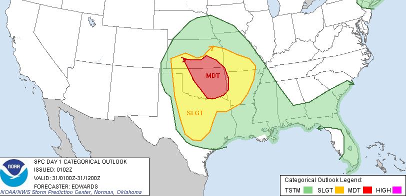
Damaging Wind Event Possible TonightMost of NE Oklahoma is now not only under a severe thunderstorm watch but also now under a moderate risk of severe weather
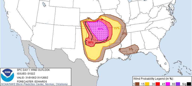
with the primary threat being a damaging wind event with winds to 80MPH or possibly higher across parts of northern and NE
Oklahoma.
Stayed tuned to the local media as the storms approach late tonight and have your NOAA weather radio
set to alert you if severe weather approaches.
Here is the SPC risk map for tonight.
Damaging wind risk map:
Severe Thunderstorm Watch Issued for All of NE Oklahoma Until 4:00amSEVERE THUNDERSTORM WATCH 326 IS IN EFFECT UNTIL 400 AM CDT FOR THE FOLLOWING LOCATIONS 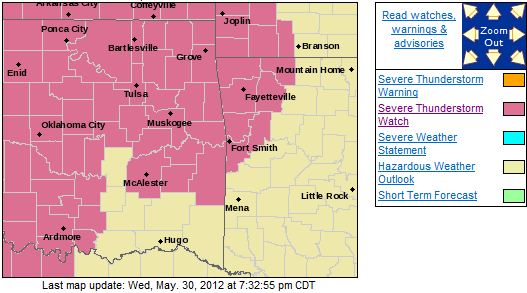 OK . OKLAHOMA COUNTIES INCLUDED ARE ADAIR
CHEROKEE CRAIG CREEK
DELAWARE HASKELL LATIMER
LE FLORE MAYES MCINTOSH
MUSKOGEE NOWATA OKFUSKEE
OKMULGEE OSAGE OTTAWA
PAWNEE PITTSBURG ROGERS
SEQUOYAH TULSA WAGONER
WASHINGTON $$
Moderate Risk Area Further North and East but Most of NE Oklahoma Under Slight RiskThe moderate risk area has been expandaded to the north and east but remains west of the Tulsa area. Still, strong to severe
storms are expected across most of eastern Oklahoma this evening and into the overnight hours. Hail to the size
of tennis balls and wind gusts to 65MPH are possible as well as a slight threat for an isolated tornado. Heavy
rain could also occur with amounts of 1-2 inches possible. Here is the latest SPC risk map. 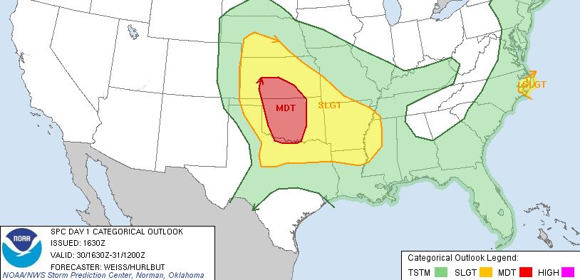
Slight to Moderate Risk of Severe Weather TodayThere is a slight to moderate risk of severe weather today with the threat increased to the west. The models currently
indicate that the bulk of the severe weather and heavy rain will remain just to the west of Tulsa but do indicate most of
NE and Eastern OK will see some rain and storms. Damaging winds, large hail, and an isolated tornado are all possible
tonight depending on where the storms form and how they interact with the remants of previous storms from the last 12 hours. Here is the SPC risk map for today: 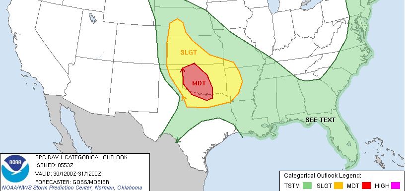
Tuesday, May 29, 2012
Severe Thunderstorm Watch Issued Until 1:00AM WednesdayTHE NATIONAL WEATHER SERVICE HAS ISSUED SEVERE THUNDERSTORM WATCH 319 IN EFFECT UNTIL 1 AM CDT WEDNESDAY FOR THE FOLLOWING
AREAS IN OKLAHOMA THIS WATCH INCLUDES 14 COUNTIES IN EAST CENTRAL OKLAHOMA MUSKOGEE
OKFUSKEE IN NORTHEAST OKLAHOMA CREEK OKMULGEE
OSAGE PAWNEE
ROGERS TULSA
WAGONER WASHINGTON
IN SOUTHEAST OKLAHOMA HASKELL
LATIMER MCINTOSH
PITTSBURG THIS INCLUDES THE CITIES
OF...BARTLESVILLE...BRISTOW... CLAREMORE...EUFAULA...MCALESTER...MUSKOGEE...OKEMAH...OKMULGEE... PAWHUSKA...PAWNEE...STIGLER...TULSA...WAGONER
AND WILBURTON. 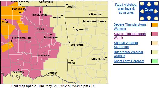 Current Local Radar at 7:35. 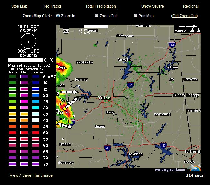
Slight Risk of Severe Weather Today. Greater Risk TomorrowThere is a slight risk of severe weather this after and evening across all of NE Oklahoma. There is a threat for isolated
storms to form arfter 1:00 and they weill become more numberous at 6:00. Winds to 70MPH, mail to the size of baseballs,
and an isolated tornado appear to be the threats at this time. Here is the latest risk map: 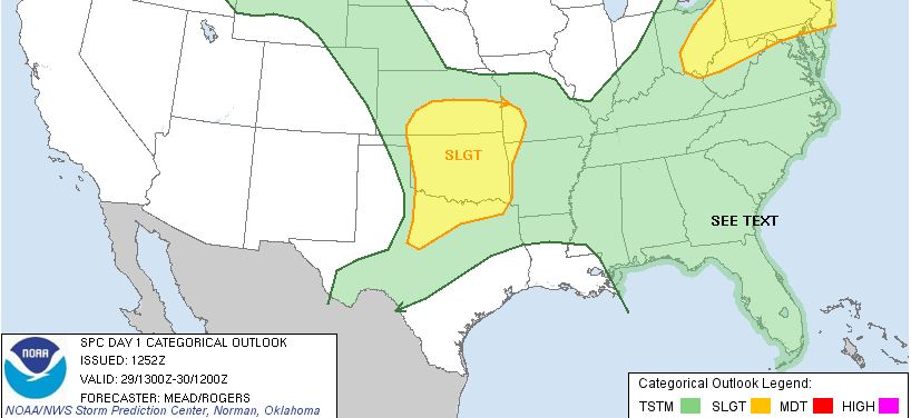 There is a grester risk of severe weather on Wednesday with the potential for a significant severe weather
outbreak to occur, especially to the of the Tulsa area. Details and updates to follow...
Monday, May 28, 2012
Slight Risk of Severe Weather on TuesdayThere is a slight risk of severe weather on Tuesday night. Large hail and damaging winds are the primary threats. There will
be a risk Wednesday and Thursday as well. Here is the risk area for Tuesday: 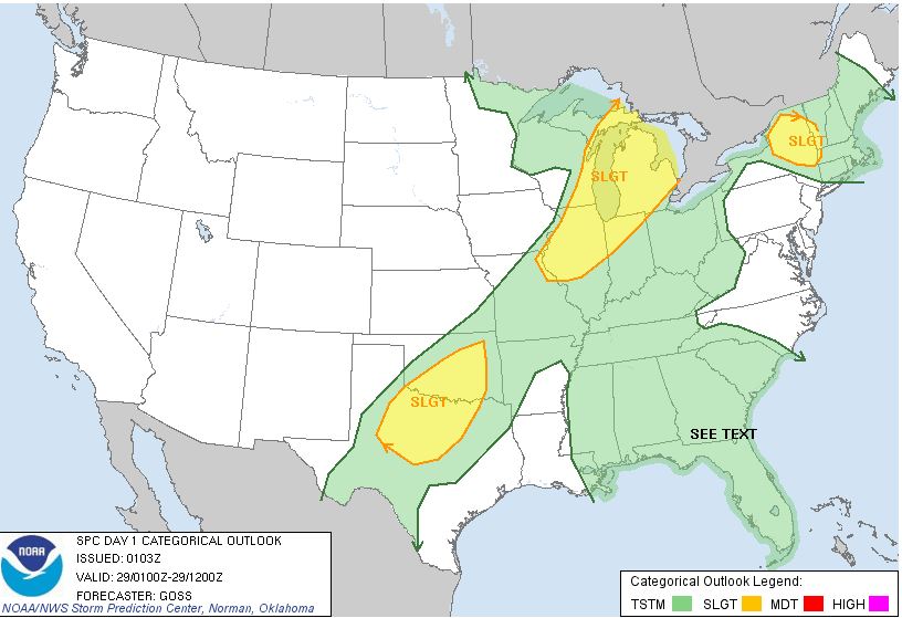
Sunday, May 20, 2012
Severe Thunderstorm Watch Cancelled50% chance of thunderstorms in NE Oklahoma tomorrow but no severe weather expected.
Sun, May 20, 2012 | link
Saturday, May 19, 2012
Severe Thunderstorm Watch Issued West of TulsaSEVERE THUNDERSTORM WATCH OUTLINE UPDATE FOR WS 284 NWS STORM PREDICTION CENTER NORMAN OK 905 PM CDT SAT MAY 19
2012 SEVERE THUNDERSTORM WATCH 284 IS IN EFFECT UNTIL 400 AM CDT FOR THE FOLLOWING LOCATIONS OKC003-009-011-015-017-031-033-039-043-047-051-053-055-057-065- 071-073-075-083-093-103-113-117-119-137-141-149-200900- /O.NEW.KWNS.SV.A.0284.120520T0205Z-120520T0900Z/ OK . OKLAHOMA COUNTIES INCLUDED ARE ALFALFA
BECKHAM BLAINE CADDO
CANADIAN COMANCHE COTTON
CUSTER DEWEY GARFIELD
GRADY GRANT GREER
HARMON JACKSON KAY
KINGFISHER KIOWA LOGAN
MAJOR NOBLE OSAGE
PAWNEE PAYNE STEPHENS
TILLMAN WASHITA 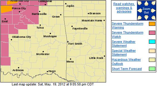
Sunday, May 6, 2012
Severe Storms Possible This AfternoonThere is a threat of severe weather this afternoon across all of NE Oklahome with hail to the size of baseballs and damaging
winds being the primary threat. Tulsa NWS risk map for today: 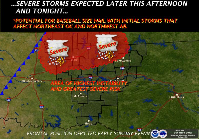
|