|
Monday, April 30, 2012
Tornado Watch ExpandedA tornado watch is in effect for all counties in yellow until 2:00AM.
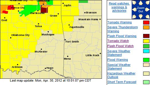
A Tornado Watch Has Been Issued for Most of NE Oklahoma.THE NATIONAL WEATHER SERVICE HAS ISSUED TORNADO WATCH 214 IN EFFECT UNTIL 2 AM CDT TUESDAY FOR THE FOLLOWING AREAS 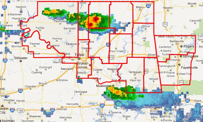 IN OKLAHOMA THIS WATCH INCLUDES 13 COUNTIES IN EAST CENTRAL OKLAHOMA CHEROKEE
IN NORTHEAST OKLAHOMA ADAIR
CRAIG DELAWARE
MAYES NOWATA
OSAGE OTTAWA
PAWNEE ROGERS
TULSA WAGONER
WASHINGTON THIS INCLUDES THE CITIES OF...BARTLESVILLE...BENTONVILLE... CLAREMORE...FAYETTEVILLE...JAY...MIAMI...NOWATA...PAWHUSKA... PAWNEE...PRYOR...ROGERS...SPRINGDALE...STILWELL...TAHLEQUAH... TULSA...VINITA AND WAGONER.
Flash Flood Watch Issued for Parts of NE Oklahoma...ADDITIONAL HEAVY RAINFALL POSSIBLE OVERNIGHT ACROSS PARTS OF NORTHEAST OKLAHOMA.... OKZ054>059-010300- ...FLASH FLOOD WATCH IN EFFECT FROM 7 PM CDT THIS EVENING THROUGH TUESDAY MORNING... THE NATIONAL
WEATHER SERVICE IN TULSA HAS ISSUED A * FLASH FLOOD WATCH FOR A PORTION OF NORTHEAST OKLAHOMA... INCLUDING
THE FOLLOWING AREAS...CRAIG...NOWATA...OSAGE... OTTAWA...PAWNEE AND WASHINGTON. * FROM 7 PM CDT THIS
EVENING THROUGH TUESDAY MORNING 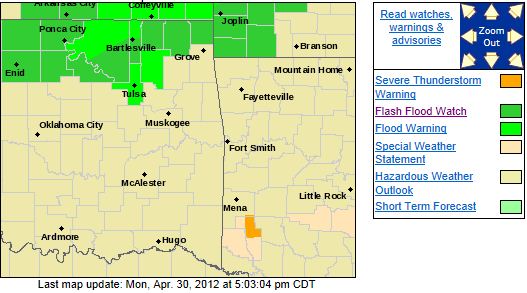 * AN UPPER LEVEL DISTURBANCE IN THE WESTERLY FLOW ALOFT WILL ENTER THE SOUTHERN PLAINS OVERNIGHT.
ADDITIONAL SHOWER AND THUNDERSTORM DEVELOPMENT WILL LIKELY TAKE PLACE TO THE WEST AND MOVE EAST...IMPACTING
PARTS OF NORTHEAST OKLAHOMA LATER TONIGHT. RADAR ESTIMATES OF 3 TO 7 INCHES OF RAIN HAS FALLEN OVER PARTS
OF NORTHEAST OKLAHOMA...AND HAS RESULTED IN NUMEROUS FLOODING PROBLEMS LAST NIGHT AND THIS MORNING. WHILE THERE
IS UNCERTAINTY CONCERNING THE DETAILS OF TONIGHTS RAINFALL SETUP...ANTECEDENT CONDITIONS COMBINED
WITH ADDITIONAL RAINFALL POTENTIAL FROM TONIGHTS SYSTEM WILL RAPIDLY AGGRAVATE ALREADY FLOODED AREAS.
THEREFORE...A FLASH FLOOD WATCH WILL IN EFFECT TONIGHT. PRECAUTIONARY/PREPAREDNESS ACTIONS... IF
YOU ARE IN THE WATCH AREA...KEEP INFORMED...AND BE READY FOR QUICK ACTION IF FLASH FLOODING IS OBSERVED OR IF A WARNING
IS ISSUED. BE ESPECIALLY CAUTIOUS AT NIGHT WHEN IT IS HARDER TO RECOGNIZE THE DANGERS OF FLASH FLOODS.
IF FLASH FLOODING IS OBSERVED...ACT QUICKLY. DO NOT STAY IN AREAS SUBJECT TO FLOODING WHEN WATER BEGINS TO RISE.
MOTORISTS SHOULD NOT DRIVE THROUGH WATER OF UNKNOWN DEPTH. TAKE A DIFFERENT ROUTE TO REACH YOUR DESTINATION OR WAIT
UNTIL THE WATER RECEDES.
Sunday, April 29, 2012
Severe Thunderstorm Watch IssuedSEVERE THUNDERSTORM WATCH OUTLINE UPDATE FOR WS 205 NWS STORM PREDICTION CENTER NORMAN OK 805 PM CDT SUN APR 29
2012 SEVERE THUNDERSTORM WATCH 205 IS IN EFFECT UNTIL 300 AM CDT FOR THE FOLLOWING LOCATIONS OKC003-011-035-037-039-041-043-045-047-053-071-073-081-083-093- 097-103-105-113-115-117-119-129-131-143-145-147-151-153- 300800- /O.NEW.KWNS.SV.A.0205.120430T0105Z-120430T0800Z/ OK . OKLAHOMA COUNTIES INCLUDED ARE ALFALFA
BLAINE CRAIG CREEK
CUSTER DELAWARE DEWEY
ELLIS GARFIELD GRANT
KAY KINGFISHER LINCOLN
LOGAN MAJOR MAYES
NOBLE NOWATA OSAGE
OTTAWA PAWNEE PAYNE
ROGERS ROGER MILLS TULSA
WAGONER WASHINGTON WOODS
WOODWARD $$ 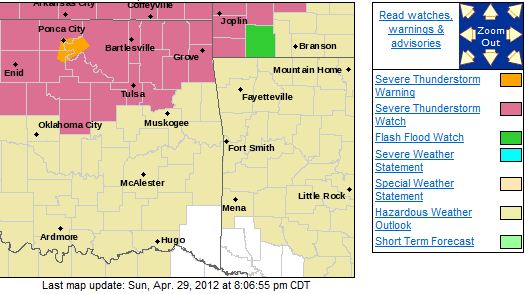 ATTN...WFO...ICT...OUN...TSA...SGF...
Slight Risk of Severe Weather and Flash Flood Threat TonightThe severe threat is across most of NE Oklahoma mainly after 5:00 and the flash flood threat is mainly north of I-44. Multiple
rounds of thunderstorms are expected over the next few days but most of this activity will remain north of I-44. Here is the Tulsa NWS risk graphic for this evening and tomorrow. 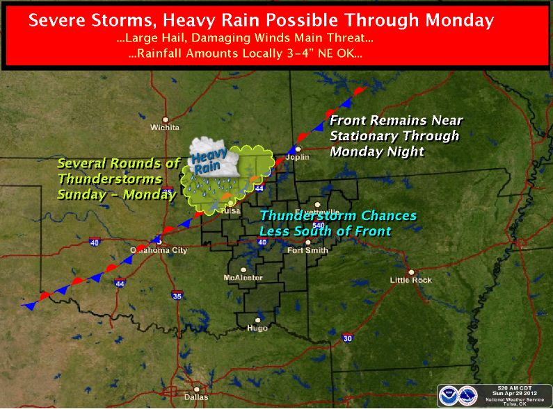
Saturday, April 28, 2012
Severe Thunderstorm Watch Issued Until 5:00AMTHE NATIONAL WEATHER SERVICE HAS ISSUED SEVERE THUNDERSTORM WATCH 202 IN EFFECT UNTIL 5 AM CDT SUNDAY FOR THE FOLLOWING
AREAS IN OKLAHOMA THIS WATCH INCLUDES 19 COUNTIES IN EAST CENTRAL OKLAHOMA CHEROKEE
MUSKOGEE OKFUSKEE
SEQUOYAH IN NORTHEAST OKLAHOMA ADAIR CRAIG
CREEK DELAWARE
MAYES NOWATA
OKMULGEE OSAGE
OTTAWA PAWNEE
ROGERS TULSA
WAGONER WASHINGTON
IN SOUTHEAST OKLAHOMA MCINTOSH
THIS INCLUDES THE CITIES OF...BARTLESVILLE...BRISTOW... CLAREMORE...EUFAULA...JAY...MIAMI...MUSKOGEE...NOWATA...OKEMAH... OKMULGEE...PAWHUSKA...PAWNEE...PRYOR...SALLISAW...STILWELL... TAHLEQUAH...TULSA...VINITA AND WAGONER. 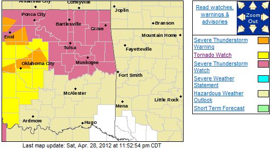 
Severe Weather Threat Remains for This EveningThe threat for severe weather remains for most of NE Oklahoma this evening. Large hail and damaging winds are possible after
midnight as well as an isolated tornado threat for areas south of the Tulsa metro. There is also heavy rain threat
mostly north of I-44. Here is the Tulsa NWS risk map for this evening: 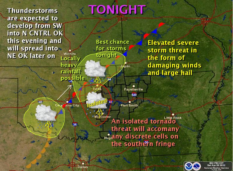
There is a Slight Risk of Severe Weather Late Tonight into Sunday MorningLarge hail and damaging winds are the primary threats mainly along the I-44 corridor but there is also a heavy rain
threat mainly north of I-44. Here is the SPC risk map for tonight: 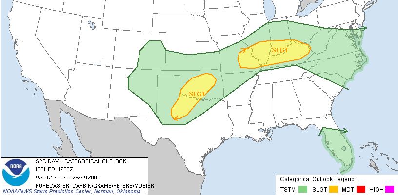
Friday, April 27, 2012
There is a Risk of Severe Weather This Evening Across Parts of NE OKThe greatest threat lies in South Central and SE Kansas but there is a possibility of a few storms forming across NE Oklahoma.
If any storms do form the will have the capability of producing damaging winds, large hail, and even a tornado. Here
is the SPC risk graphic for this evening: 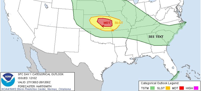 Updates to follow as needed.
Thursday, April 19, 2012
There is a Slight Risk for Severe Weather this Afternoon and EveningThere is a slight risk of severe weather over most of NE Oklahoma late this afternoon and evening, mainly between the hours
of 4:00pm and midnight. Damaging winds and large hail are the primary threats. Here is the risk
area as noted by the Storm Prediction Center: 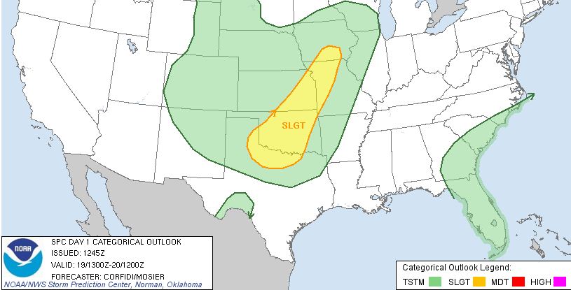
Sunday, April 15, 2012
Tornado Watch Issued for areas NW and West of TulsaIn NE Oklahoma, Osage Pawnee, and Payne Counties until 6:00 AM Sunday, Tornadoes, damaging thunderstorm winds, and hail
are possible in these areas. 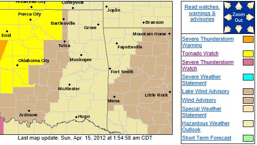
Saturday, April 14, 2012
Severe Storms Expected After MidnightDamaging winds, hail, and heavy rain likey. Here is the NWS risk graphic for tonight with timing, 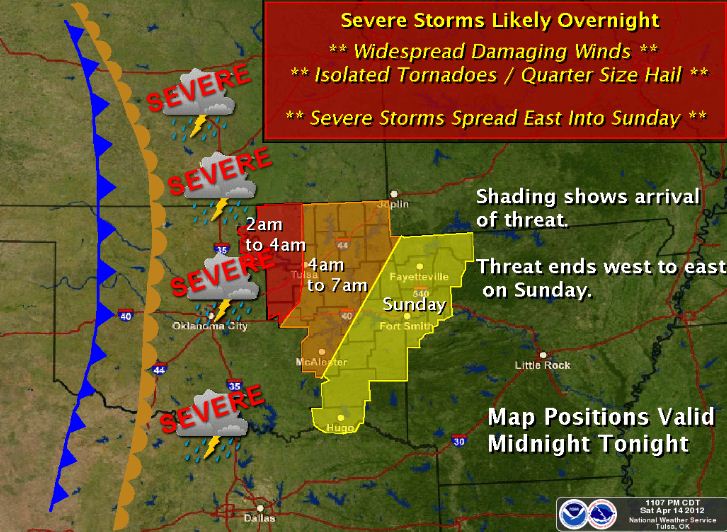
Severe Weather Threat Minimized for this eveningIt appears that the severe weather threat for this evening may not be realized and that a squall line will affect the area
very early Sunday morning.
Updates to follow...
Sat, April 14, 2012 | link
Severe Weather Outbreak Still Expected This EveningThere is a high probability of a significant tornado outbreak today across much of Oklahoma, Kansas, and Nebraska. If you evening plans away from home, especially outdoors, please stayed tune to your
NOAA weather radio or AM740/FM102.3 KRMG for the latest on this possibly very dangerous outbreak.
If you here the
sirens, PLEASE do not go outside. Have your shelter ready with a radio to listen to get into it as quickly as possible.Discrete supercells capable of producing damaging wind gusts, hail to the size of tennis balls, and large, long
track tornadoes are expected to form in central Oklahoma along the dryline and track east into eastern Oklahoma this evening. The most likely time for tornadoes will be from 6PM - 10PM. It is possible that the storms will form a squall line
as they enter eastern Oklahoma that could affect us through Sunday morning The squall line would lessen the tornado threat
but not eliminate it and still produce a very large hail threat and damaging wind threat. Here is the SPC tornado risk
map for today: 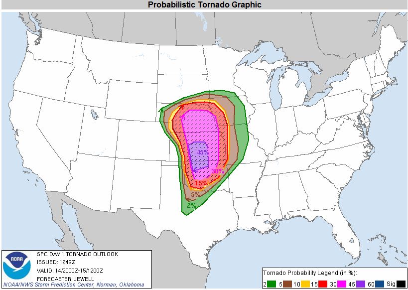 Here is the Tulsa NWS eastern OK risk map for today: 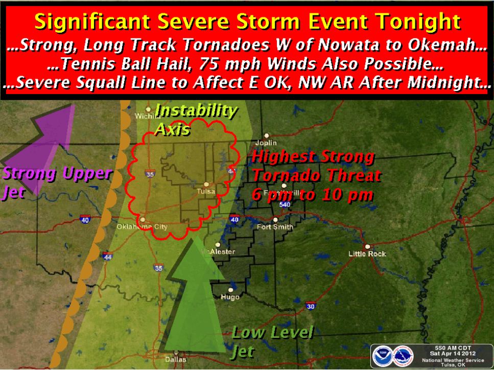 Here are some severe weather safety tips that would be good to review for this evening: http://www.tulsagoldenhurricane.com/id7.html Here are some severe weather safety tips that would be good to review for this evening: http://www.tulsagoldenhurricane.com/id7.html Tornado Safety Rules · In a home or building, move to a pre-designated shelter, such as a basement. · If an underground shelter is not available, move to a small interior room or hallway on the lowest floor and get under
a sturdy piece of furniture. Put as many walls as possible · between you and the outside. · Stay away from windows. · Get out of automobiles. · Do not try to outrun a tornado in your car; instead, leave immediately for safe shelter. · If caught outside or in a vehicle, lie flat in a nearby ditch or depression and cover your head with
your hands. · Be aware of flying debris. Flying debris from tornadoes causes most fatalities and injuries. · Mobile homes, even if tied down, offer little protection from tornadoes. You should leave a mobile home and go to the
lowest floor of a sturdy nearby building or a storm shelter.
Updates to follow...
High Risk of Significant Severe Weather Outbreak This EveningThere is a high probability of a significant tornado outbreak today across much of Oklahoma, Kansas, and Nebraska. If you evening plans away from home, especially outdoors, please stayed tune to your
NOAA weather radio or AM740/FM102.3 KRMG for the latest on this possibly very dangerous outbreak.
If you here the
sirens, PLEASE do not go outside. Have your shelter ready with a radio to listen to get into it as quickly as possible.Discrete supercells capable of producing damaging wind gusts, hail to the size of tennis balls, and large, long
track tornadoes are expected to form in central Oklahoma along the dryline and track east into eastern Oklahoma this evening. The most likely time for tornadoes will be from 6PM - 10PM. It is possible that the storms will form a squall line
as they enter eastern Oklahoma that could affect us through Sunday morning The squall line would lessen the
tornado threat but not eliminate it and still produce a very large hail threat and damaging wind threat. Here is
the SPC risk map for today: 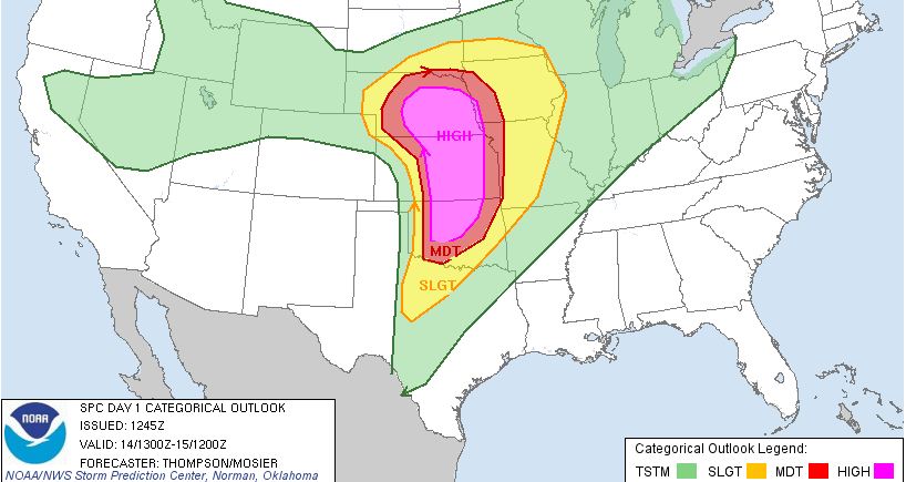 Here is the Tulsa NWS eastern OK risk map for today:  Here are some severe weather safety tips that would be good to review for this evening: http://www.tulsagoldenhurricane.com/id7.html Here are some severe weather safety tips that would be good to review for this evening: http://www.tulsagoldenhurricane.com/id7.html Tornado Safety Rules · In a home or building, move to a pre-designated shelter, such as a basement. · If an underground shelter is not available, move to a small interior room or hallway on the lowest floor and get under
a sturdy piece of furniture. Put as many walls as possible · between you and the outside. · Stay away from windows. · Get out of automobiles. · Do not try to outrun a tornado in your car; instead, leave immediately for safe shelter. · If caught outside or in a vehicle, lie flat in a nearby ditch or depression and cover your head with
your hands. · Be aware of flying debris. Flying debris from tornadoes causes most fatalities and injuries. · Mobile homes, even if tied down, offer little protection from tornadoes. You should leave a mobile home and go to the
lowest floor of a sturdy nearby building or a storm shelter.
Updates to follow...
Friday, April 13, 2012
Tornado Watch Extended East. Tulsa Included.Stayed tuned to local media for further reports for tonights storms. Updates forthcoming for Saturday... Watch Area: 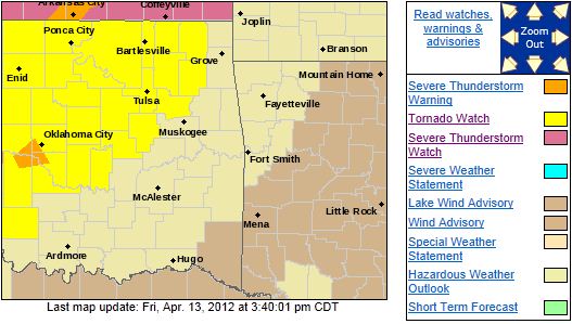
Two rounds of Severe Weather Now Possible Today as Storms are forming just to our West.Just a quick update as storms have begun firing to the west that may impact NE OK in the next couple of hours then another
round that is developing in SW Oklahoma that could impact NE OK this evening.
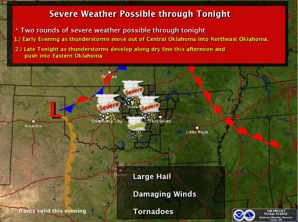
Tornado Watch Issued West and NW of Tulsa for This Evening. Severe Weather Still Expected Saturday Night.
Fri, April 13, 2012 | link
Slight Risk of Severe Weather Tonight, much Higher Risk Saturday NightThere is a slight risk of severe weather tonight with heavy rain, large hail, damaging winds, and tornadoes with the greatest
chance of very large hail and tornadoes currently looking to be across areas north of I-44 and west of highway 75 but
possible anywhere in NE Oklahoma. Here is the latest SPC risk map indicating the areas of risk. I would not be
surprised to see a portion of the slight risk area upgraded to a moderate risk later today. 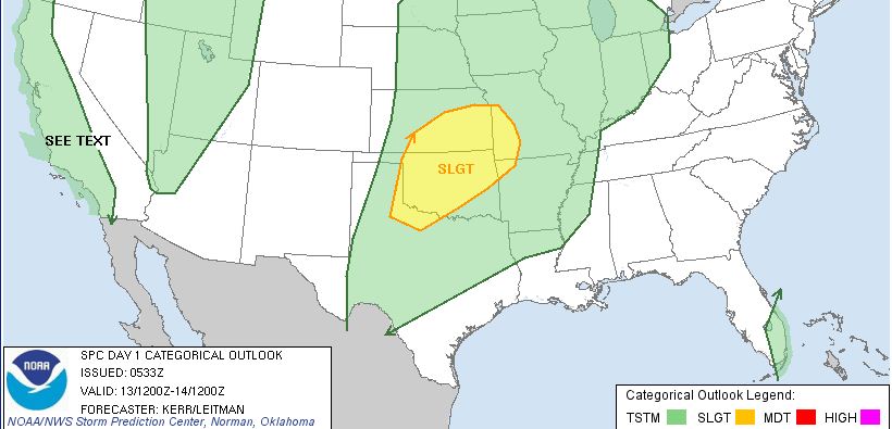 The is a much greater risk of severe weather saturday night, especially across north central Oklahoma
but also extending as far east as highway 69. Life threatening risks in
damaging wind gusts to 100+ MPH, hail to the size of baseballs, and large, long track tornadoes all appear possible in the
moderate and high risk areas on Saturday night.
The threat could transition into a heavy rain,
large hail, damaging winds, and isolated tornado event by the time the storms reach eastern Oklahoma if they join together
and form a solid line of storms. If the storms remain discrete, or seperate, as they enter eastern Oklahoma then the threats
will be life threatening with those storms. Please pay extra attention to the local media
and make sure your NOAA Weather Radio is functioning properly to alert you as it appears the severe storms will be impacting
eastern Oklahoma after dark and likely even into the overnight hours.Here is the latest
SPC risk map for Saturday: 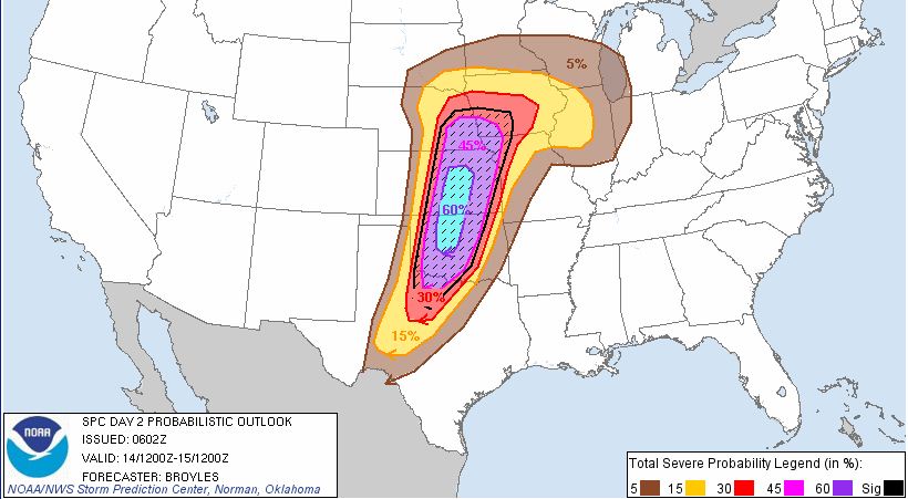
Here are some severe weather safety tips that would be good to review in preperation
for these multiple rounds of severe weather: http://www.tulsagoldenhurricane.com/id7.html Tornado Safety Rules · In a home or building, move to a pre-designated shelter, such as a basement. · If an underground shelter is not available, move to a small interior room or hallway on the lowest floor and get under
a sturdy piece of furniture. Put as many walls as possible · between you and the outside. · Stay
away from windows. · Get out of automobiles. · Do not try to outrun a tornado in your car; instead, leave immediately for safe shelter. · If caught outside or in a vehicle, lie flat in a nearby ditch or depression and cover your head with
your hands. · Be aware of flying debris. Flying debris from tornadoes causes most fatalities and injuries. · Mobile homes, even if tied down, offer little protection from tornadoes. You should leave a mobile home and go to the
lowest floor of a sturdy nearby building or a storm shelter.
Updates to follow...
Thursday, April 12, 2012
Severe Weather Threat for Friday, Saturday, and Sunday RemainsThe is a slight risk of severe weather in parts of NE Oklahoma on Friday. Large hail, damaging winds, and tornadoes are possible
in the risk area. Here is the SPC risk map for Friday: 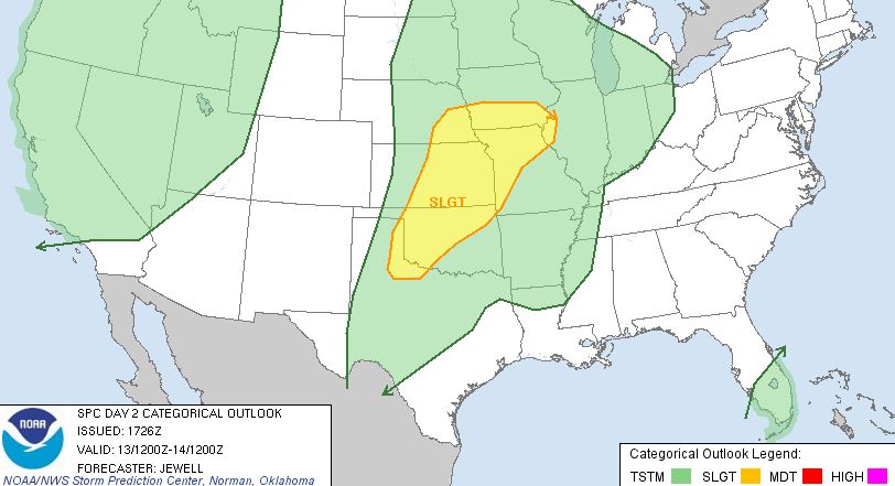 It still appears the greatest risk of severe weather will be late
Saturday afternoon through late Saturday night. It still appears the greatest risk of severe weather will be late
Saturday afternoon through late Saturday night.Here is the Tulsa NWS risk graphic for this period: 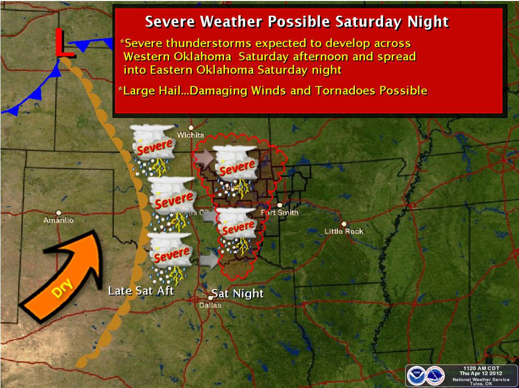 Updates to follow as the the timing and locations are better refined. Here are
some severe weather safety tips that would be good to review in preperation for Saturday: http://www.tulsagoldenhurricane.com/id7.html Tornado Safety Rules · In a
home or building, move to a pre-designated shelter, such as a basement. · If an underground shelter is not available, move to a small interior room or
hallway on the lowest floor and get under a sturdy piece of furniture. Put as many walls as possible · between
you and the outside. · Stay away from windows. · Get out of automobiles. · Do not try to outrun a tornado in your car; instead, leave immediately for safe shelter. · If caught outside or in a vehicle, lie flat in a nearby ditch or depression and cover your head with
your hands. · Be aware of flying debris. Flying debris from tornadoes causes most fatalities and injuries. · Mobile homes, even if tied down, offer little protection from tornadoes. You should leave a mobile home and go to the
lowest floor of a sturdy nearby building or a storm shelter.
Multiple Rounds of Severe Weather Expected Friday, Saturday, and possibly SundayThere is a slight risk of severe weather across parts of Eastern Oklahoma from late afternoon Friday into the nighttime hours.
Large hail, damaging winds, and tornadoes will be possible during this time. Here is the SPC risk map for Friday: 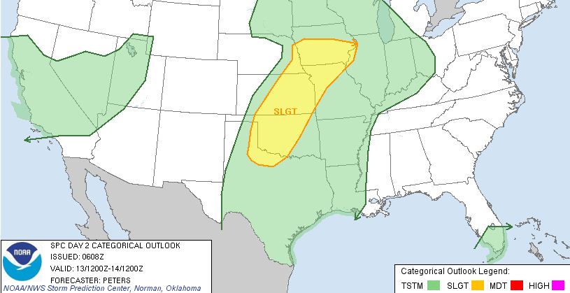 A more significant chance of severe weather will be on Saturday
into Saturday night possibly extending into the overnight hours. A more significant chance of severe weather will be on Saturday
into Saturday night possibly extending into the overnight hours.
Saturday could bring a
significant and dangerous severe weather outbreak across parts of eastern Oklahoma with very large hail, damaging
winds, and large, long track tornadoes expected at this time. Here is the SPC risk map for Saturday: 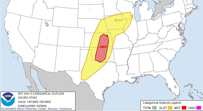 Updates to follow as the the timing and locations are better refined. Here are some
severe weather safety tips that would bo good to review in preperation for Saturday: http://www.tulsagoldenhurricane.com/id7.html Tornado Safety Rules · In a
home or building, move to a pre-designated shelter, such as a basement. · If an underground shelter is not available, move to a small interior room or
hallway on the lowest floor and get under a sturdy piece of furniture. Put as many walls as possible · between
you and the outside. · Stay away from windows. · Get out of automobiles. · Do not try to outrun a tornado in your car; instead, leave immediately for safe shelter. · If caught
outside or in a vehicle, lie flat in a nearby ditch or depression and cover your head with your hands. · Be aware of flying debris. Flying debris from tornadoes causes most fatalities and injuries. · Mobile
homes, even if tied down, offer little protection from tornadoes. You should leave a mobile home and go to the lowest floor
of a sturdy nearby building or a storm shelter.
Tuesday, April 3, 2012
Slight Risk of Severe Weather has Shifted South of Tulsa for This EveningStrong to occassionally severe storms are still expected this evening across NE Oklahoma but it appears the main severe weather
threat will remain south of Tulsa, mainly south of I-40. Here is the latest SPC risk graphic: 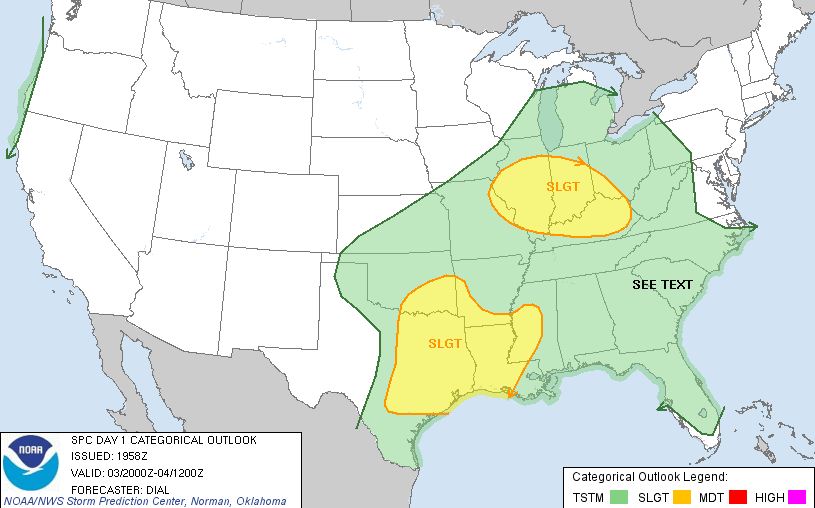
There is a Slight Risk of Severe Weather over most of NE Oklahoma late this afternoon and this eveningThere is a slight risk of severe weather late this afternoon and evening with heavy rain, damaging winds, and large hail being
the primary threat. It is possible that a tornado or two could form. Here is the SPC risk map for this afternoon
and evening: 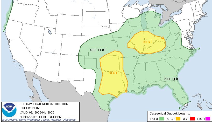 Updates to follow if needed.
Monday, April 2, 2012
Severe Thunderstorm Watch Issued for Areas South of TulsaA Severe Thunderstorm Watch has been issued for the following counties until 11:00PM: ATOKA
BRYAN CARTER COAL
HASKELL HUGHES JOHNSTON
LATIMER LE FLORE LOVE
MARSHALL MCINTOSH MURRAY
MUSKOGEE OKFUSKEE OKMULGEE
PITTSBURG PONTOTOC SEMINOLE
SEQUOYAH Heavy rain, damaging winds, and large hail are possible with any storms that form. 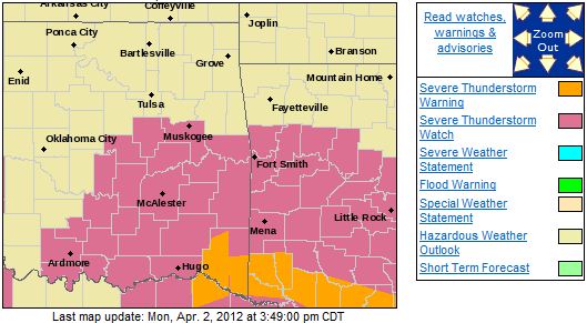
|