|
Thursday, June 28, 2012
Excessive Heat Warning Continues Through FridayEXCESSIVE HEAT WARNING REMAINS IN EFFECT UNTIL 9 PM CDT FRIDAY...
AN EXCESSIVE HEAT WARNING IS IN EFFECT...
FOR THE FOLLOWING COUNTIES...
* IN OKLAHOMA...TULSA.
HAZARDOUS WEATHER...
* HEAT INDEX
VALUES NEAR 105 DEGREES HAVE OCCURRED THIS AFTERNOON
AND ARE EXPECTED AGAIN ON FRIDAY. OVERNIGHT LOWS WILL
ONLY FALL
INTO THE MID TO UPPER 70S...ESPECIALLY IN THE TULSA METRO
AREA...PROVIDING LITTLE
RELIEF FROM THE HEAT.
IMPACTS...
* THE COMBINATION OF HOT TEMPERATURES AND HIGH HUMIDITY WILL
COMBINE TO CREATE A DANGEROUS SITUATION IN WHICH HEAT ILLNESSES
ARE POSSIBLE.
PRECAUTIONARY/PREPAREDNESS
ACTIONS...
* TAKE EXTRA PRECAUTIONS IF YOU WORK OR SPEND TIME OUTSIDE. WHEN
POSSIBLE...RESCHEDULE
STRENUOUS ACTIVITIES TO EARLY MORNING OR
EVENING. KNOW THE SIGNS AND SYMPTOMS OF HEAT EXHAUSTION AND HEAT
STROKE. WEAR LIGHT WEIGHT AND LOOSE FITTING CLOTHING WHEN
POSSIBLE AND DRINK PLENTY
OF WATER.
* TO REDUCE RISK DURING OUTDOOR WORK THE OCCUPATIONAL SAFETY AND
HEALTH ADMINISTRATION
RECOMMENDS SCHEDULING FREQUENT REST
BREAKS IN SHADED OR AIR CONDITIONED ENVIRONMENTS. ANYONE
OVERCOME BY HEAT SHOULD BE MOVED TO A COOL AND SHADED LOCATION.
HEAT STROKE IS AN EMERGENCY...CALL 911.
* NEVER LEAVE CHILDREN OR PETS IN A VEHICLE. THE TEMPERATURE IN A
CAR CAN RISE TO 172 DEGREES WITH
JUST 15 MINUTES OF DIRECT
SUNLIGHT...AND CHILDRENS BODY TEMPERATURES RISE FIVE TIMES
FASTER
THAN ADULT BODY TEMPERATURES.
* STAY TUNED TO NOAA WEATHER RADIO...COMMERCIAL RADIO OR TELEVISION
FOR THE LATEST INFORMATION CONCERNING THIS WEATHER EVENT.
ADDITIONAL WEATHER INFORMATION CAN ALSO BE FOUND
AT:
WEATHER.GOV/TULSA.
Thu, June 28, 2012 | link
Wednesday, June 27, 2012
EXCESSIVE HEAT WARNING IN EFFECT UNTIL 9 PM CDT THURSDAY
THE NATIONAL WEATHER SERVICE IN TULSA HAS ISSUED AN EXCESSIVE HEAT
WARNING...WHICH IS IN EFFECT UNTIL 9
PM CDT THURSDAY...
FOR THE FOLLOWING COUNTIES...
* IN OKLAHOMA...TULSA.
* THIS WARNING REPLACES
THE ADVISORY THAT WAS IN EFFECT.
HAZARDOUS WEATHER...
* AFTERNOON HEAT INDICES
ARE EXPECTED TO REACH INTO THE 105 TO
110 DEGREE RANGE THROUGH THURSDAY. IN ADDITION...OVERNIGHT LOWS
WILL REMAIN WARM IN THE UPPER 70S...PROVIDING LITTLE RELIEF
FROM THE HEAT.
IMPACTS...
* THE COMBINATION OF HOT TEMPERATURES AND HIGH HUMIDITY WILL
COMBINE TO CREATE
A DANGEROUS SITUATION IN WHICH HEAT ILLNESSES
ARE POSSIBLE.
DEFINITION...
* AN EXCESSIVE
HEAT WARNING MEANS THAT A PROLONGED PERIOD OF HOT
TEMPERATURES WILL OCCUR.
PRECAUTIONARY/PREPAREDNESS
ACTIONS...
* TAKE EXTRA PRECAUTIONS IF YOU WORK OR SPEND TIME OUTSIDE. WHEN
POSSIBLE...RESCHEDULE
STRENUOUS ACTIVITIES TO EARLY MORNING OR
EVENING. KNOW THE SIGNS AND SYMPTOMS OF HEAT EXHAUSTION AND HEAT
STROKE. WEAR LIGHT WEIGHT AND LOOSE FITTING CLOTHING WHEN
POSSIBLE AND DRINK PLENTY
OF WATER.
* TO REDUCE RISK DURING OUTDOOR WORK THE OCCUPATIONAL SAFETY AND
HEALTH ADMINISTRATION
RECOMMENDS SCHEDULING FREQUENT REST
BREAKS IN SHADED OR AIR CONDITIONED ENVIRONMENTS. ANYONE
OVERCOME BY HEAT SHOULD BE MOVED TO A COOL AND SHADED LOCATION.
HEAT STROKE IS AN EMERGENCY...CALL 911.
* ADDITIONAL WEATHER INFORMATION CAN ALSO BE FOUND AT:
WEATHER.GOV/TULSA.
Wed, June 27, 2012 | link
Monday, June 11, 2012
Storms look to stay east of the area. Storm risk for Tulsa area is slight.The storms have unable to develop over our area due to the strong cap that is in place.
The storm threat for most of
NE Oklahoma, especially west of highway 69 is pretty light.
There is another shot at some rain and thunderstorms
Tuesday night into Wednesday.
Mon, June 11, 2012 | link
Slight Risk of Severe Weather Today Across NE OklahomaIf storms can fire late this morning then the Tulsa area could possibly impacted by severe weather this afternoon with large
hail and damaging winds being the main threats. Here is the risk are per the SPC: 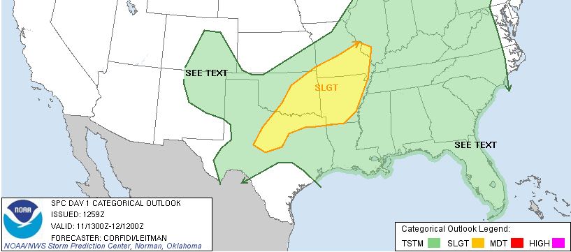
Sunday, June 10, 2012
Severe Threat Remains Late Tonight Through Monday AfternoonTherer remains a slight risk of severe waether over the next 24 hours with large hail and damaging winds being the primary
threat. A severe thunderstorm watch has been issued for south central Kansas. The threat for Tulsa
is roughly form midnight through 8:00 pm Monday evening. Here are the SPC risk maps for tonight and tomorrow. 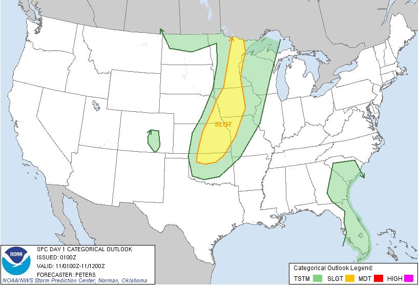 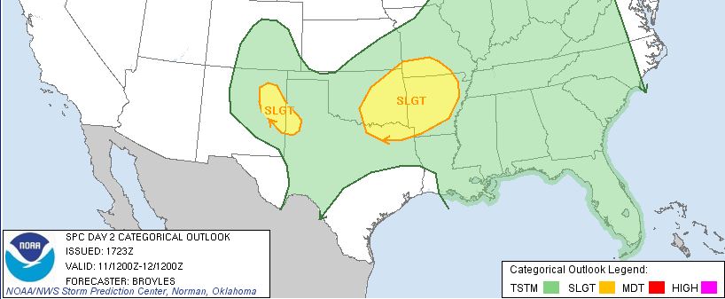
Slight Risk of Severe Weather on Sunday for the NW Parts of NE OklahomaWhile the risk for severe weather is slight it will progress across all of NE Oklahoma through the overnight period Sunday
and into Monday. Sundays risk is late evening with large hail being the primary threat at this time. Here
is the Sunday SPC risk map. 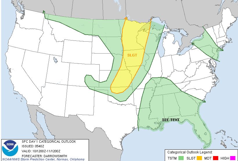
Sunday, June 3, 2012
Severe Thunderstorm Watch Issued For NE OklahomaBULLETIN - IMMEDIATE BROADCAST REQUESTED SEVERE THUNDERSTORM WATCH OUTLINE UPDATE FOR WS 350 NWS STORM PREDICTION CENTER NORMAN OK 1125 PM CDT SUN JUN 3 2012 SEVERE THUNDERSTORM WATCH 350 IS IN EFFECT UNTIL 700 AM CDT
FOR THE FOLLOWING LOCATIONS OK
. OKLAHOMA COUNTIES INCLUDED ARE ADAIR
CHEROKEE CRAIG
CREEK
DELAWARE HASKELL
LE FLORE MAYES
MCINTOSH MUSKOGEE
NOWATA OKMULGEE
OSAGE
OTTAWA PAWNEE
ROGERS
SEQUOYAH TULSA
WAGONER WASHINGTON
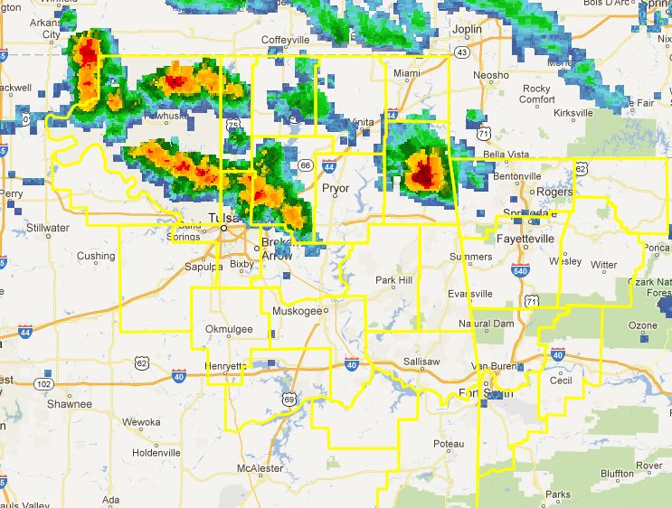
Tornado Watch CancelledStorms still look possible but confidence is not very high and if they do form, the tornado threat will be low. It is still likely
that a severe thunderstorm watch may be issued later this evening.
Sun, June 3, 2012 | link
Tornado Watch Issued Just West of Tulsa Until 2:00AM 640 PM CDT SUN JUN 3 2012 TORNADO WATCH
347 IS IN EFFECT UNTIL 200 AM CDT FOR THE FOLLOWING LOCATIONS OK . OKLAHOMA COUNTIES INCLUDED ARE
ALFALFA BEAVER
BLAINE CANADIAN
CREEK CUSTER
DEWEY
ELLIS GARFIELD
GRANT
HARPER KAY
KINGFISHER LINCOLN
LOGAN MAJOR
NOBLE OKFUSKEE
OKLAHOMA OSAGE
PAWNEE PAYNE
ROGER MILLS WOODS
WOODWARD 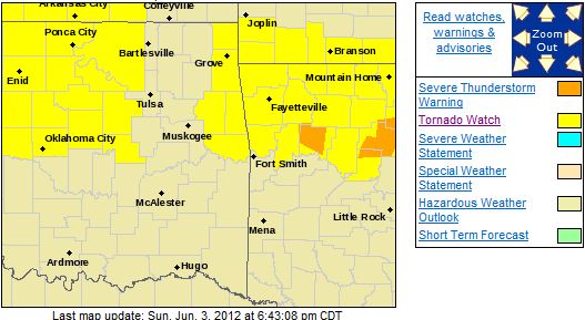
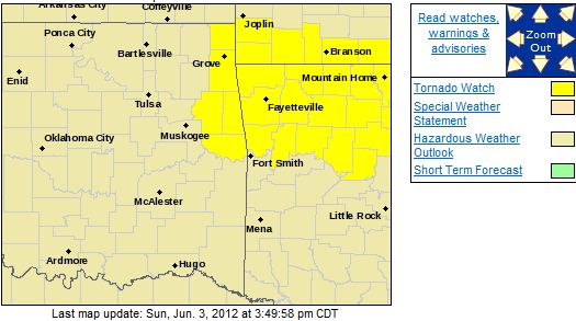
Tornado Watch Issued East of TulsaNWS STORM PREDICTION CENTER NORMAN OK 330 PM CDT SUN JUN 3 2012 TORNADO WATCH 345 IS IN EFFECT UNTIL 1100 PM CDT FOR
THE FOLLOWING LOCATIONS
OKLAHOMA COUNTIES INCLUDED ARE ADAIR CHEROKEE DELAWARE OTTAWA SEQUOYAH
Severe Storms Expected This Afternoon and EveningSevere thunderstorms are expected to impact the area this afternoon and this evening. Large hail and damaging winds are
the primary threats but heavy rain will also be possible with some of the storms. Here is the latest Tulsa
NWS risk map: 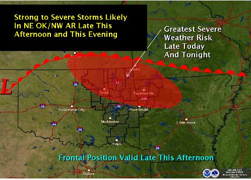
|