|
Friday, May 31, 2013
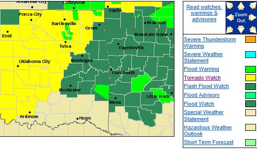
Tornado Watch Issued until 4:00 AM For Parts of E OK. Tulsa not included.TORNADO WATCH OUTLINE UPDATE FOR WT 268
NWS STORM PREDICTION CENTER NORMAN OK
1125 PM CDT FRI MAY 31 2013
TORNADO WATCH 268 IS IN EFFECT UNTIL
400 AM CDT FOR THE
FOLLOWING LOCATIONS
ARC005-007-009-015-033-047-071-083-087-089-101-115-127-129-131-
143-149-010900-
/O.NEW.KWNS.TO.A.0268.130601T0425Z-130601T0900Z/
AR
. ARKANSAS COUNTIES INCLUDED ARE
BAXTER
BENTON BOONE
CARROLL CRAWFORD
FRANKLIN
JOHNSON
LOGAN MADISON
MARION
NEWTON POPE
SCOTT
SEARCY SEBASTIAN
WASHINGTON YELL
OKC001-021-041-061-077-079-091-097-101-107-111-121-135-145-
010900-
/O.NEW.KWNS.TO.A.0268.130601T0425Z-130601T0900Z/
OK
. OKLAHOMA COUNTIES INCLUDED ARE
ADAIR
CHEROKEE DELAWARE
HASKELL LATIMER
LE FLORE
MAYES
MCINTOSH MUSKOGEE
OKFUSKEE OKMULGEE
PITTSBURG
SEQUOYAH
WAGONER
ATTN...WFO...LZK...TSA...
Fri, May 31, 2013 | link
More Storms Expected Tonight!From the Tulsa NWS:
Severe thunderstorms and significant flash flooding remain possible
tonight. Large hail, damaging winds, and isolated tornadoes will be the primary threats. Heavy rains on already saturated
soils will lead to dangerous and possibly life threatening flash flooding tonight and into tomorrow morning.
Fri, May 31, 2013 | link
PARTICULARLY DANGEROUS SITUATION Tornado Watch IssuedTHE NATIONAL WEATHER SERVICE HAS ISSUED TORNADO WATCH 262 IN EFFECT UNTIL MIDNIGHT CDT TONIGHT FOR THE FOLLOWING AREAS IN OKLAHOMA THIS WATCH INCLUDES 13 COUNTIES IN EAST CENTRAL OKLAHOMA OKFUSKEE
IN NORTHEAST OKLAHOMA CRAIG
CREEK MAYES
NOWATA OKMULGEE
OSAGE OTTAWA
PAWNEE ROGERS
TULSA WAGONER
WASHINGTON THIS INCLUDES THE CITIES OF...BARTLESVILLE...BRISTOW... CLAREMORE...MIAMI...NOWATA...OKEMAH...OKMULGEE...PAWHUSKA... PAWNEE...PRYOR...TULSA...VINITA AND WAGONER. TORNADO WATCH PROBABILITIES FOR WT 0262 NWS STORM PREDICTION CENTER
NORMAN OK 0326 PM CDT FRI MAY 31 2013 WT 0262 PDS PROBABILITY TABLE:
PROB OF 2 OR MORE TORNADOES : 90%
PROB OF 1 OR MORE STRONG /F2-F5/ TORNADOES : 70%
PROB
OF 10 OR MORE SEVERE WIND EVENTS : 90%
PROB OF 1 OR MORE WIND EVENTS >= 65 KNOTS : 50%
PROB OF 10 OR MORE SEVERE HAIL EVENTS : >95%
PROB OF 1 OR MORE HAIL EVENTS >= 2 INCHES
: 90%
PROB OF 6 OR MORE COMBINED SEVERE HAIL/WIND EVENTS : >95%
&&
ATTRIBUTE TABLE:
MAX HAIL /INCHES/ : 4.0
MAX WIND GUSTS SURFACE /KNOTS/ : 70
MAX TOPS
/X 100 FEET/ : 600
MEAN STORM MOTION VECTOR /DEGREES AND KNOTS/ : 26025
PARTICULARLY DANGEROUS SITUATION : YES
***Significant Severe Weather Outbreak Expected***Please verify your plans for taking cover NOW so when the
times comes, you can easily get into a safe place.Storms are expected to form
west of Tulsa and move into NE OK this afternoon between 3 and 4pm. These storms will very rapidly become severe supercells
that will be capable of producing hail to the size of baseballs and large, long track tornados, and heavy rain. These
storms will eventually form a line of storms which typically dramatically reduces the tornado threat. Tonight, tornados, hail
to the size of baseballs, wind gusts to 70 MPH and widespread rainfall of 3-5 inches. This threat will continue
after dark so please ensure you have a way to get NWS weather alerts if you go to bed or are watching a movie not on Cox cable. The Storm Prediction Center is expected to upgrade parts of the moderate risk area shown
below to a high risk area with their 3:00 update.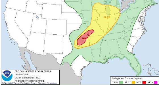 The tornado risk noted below is expected to increase as well. The tornado risk noted below is expected to increase as well.
 As is the hail threat: As is the hail threat: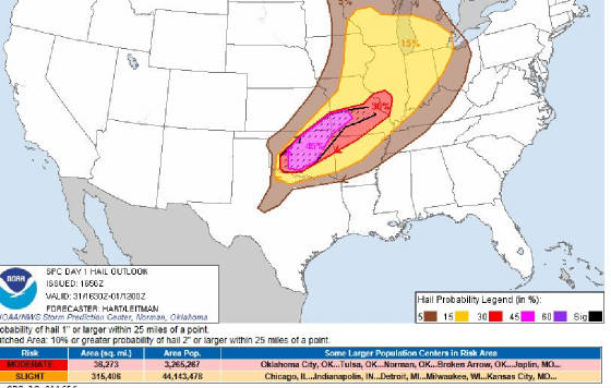 A tornado watch should be issued shortly for far NE OK within the hour for storms forming further north. Updates to follow....
Fri, May 31, 2013 | link
Severe Weather and Flooding Expected Today and TonightHail to the size of baseballs, tornados, even large tornadoes, and very heavy rain are all expected today and tonight. As storms begin forming this afternoon between 3:00 and 5:00, all modes of severe weather will be possible. Right
now is appears storms will begin to fire just NW of Tulsa and in south central OK. As the line develops and fills in into
the evening, heavy rain and large hail become the primary threats. Hail to 3.5 inches in diameter and widespread 2-4 rains
are expected. Most rain and storms should end in the Tulsa are be very early morning. Here is the NWS
risk map for today: 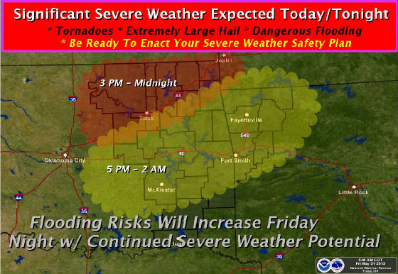
Thursday, May 30, 2013
Tornado Watch Expanded to All of Eastern OK URGENT - IMMEDIATE BROADCAST REQUESTED
TORNADO WATCH NUMBER 252
NWS STORM PREDICTION CENTER NORMAN
OK
1255 PM CDT THU MAY 30 2013
THE NWS STORM PREDICTION CENTER HAS ISSUED A
* TORNADO WATCH FOR
PORTIONS OF CENTRAL AND EASTERN OKLAHOMA
* EFFECTIVE THIS THURSDAY AFTERNOON AND EVENING FROM 1255 PM UNTIL 1000
PM CDT.
* PRIMARY THREATS INCLUDE...
SEVERAL INTENSE TORNADOES
POSSIBLE
SEVERAL VERY LARGE HAIL EVENTS TO 3 INCHES IN DIAMETER LIKELY
SEVERAL DAMAGING WIND GUSTS TO 70 MPH POSSIBLE
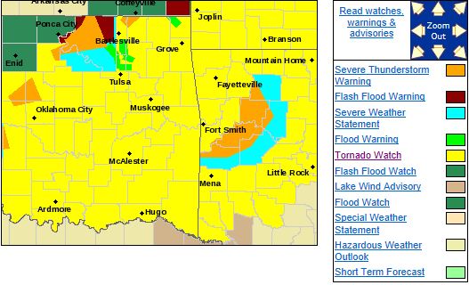
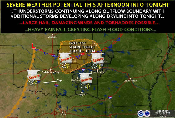
Tornado Watch Issued for Parts of NE OK until 10:00PM URGENT - IMMEDIATE BROADCAST REQUESTED
TORNADO WATCH NUMBER 252
NWS STORM PREDICTION CENTER NORMAN
OK
1255 PM CDT THU MAY 30 2013
THE NWS STORM PREDICTION CENTER HAS ISSUED A
* TORNADO WATCH FOR
PORTIONS OF CENTRAL AND EASTERN OKLAHOMA
* EFFECTIVE THIS THURSDAY AFTERNOON AND EVENING FROM 1255 PM UNTIL 1000
PM CDT.
* PRIMARY THREATS INCLUDE...
SEVERAL INTENSE TORNADOES
POSSIBLE
SEVERAL VERY LARGE HAIL EVENTS TO 3 INCHES IN DIAMETER LIKELY
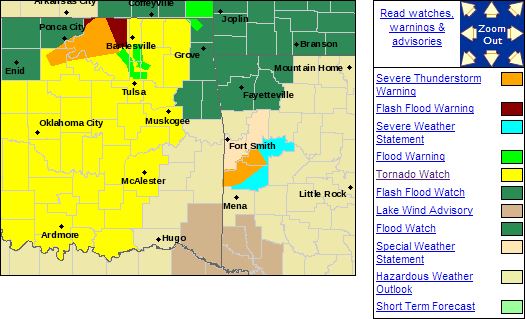
SEVERAL DAMAGING WIND GUSTS TO 70 MPH POSSIBLE

Risk of Very Severe Weather in and Around Tulsa Metro Area Today and TonightThe SPC has placed NE OK in a moderate risk are for this afternoon and evening. A boundary is expected to
be established near the Tulsa metro area this afternoon and evening. Any isolated storm
that forms and tracks along this boundary has the potential to evolve into a large
and long track tornado.
This risk area includes the Tulsa Metro Area.
Storms are expected to begin firing by 2:00PM and will quickly become supercellular and could impact NE OK after that
time. 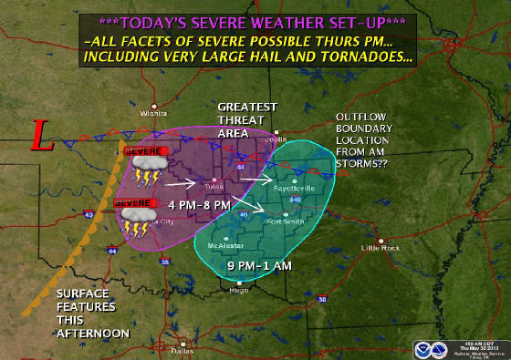 Please prepare for severe weather now. Please prepare for severe weather now.
Here is the SPC risk area for today and tonight. Large, long track tornados are possible anywhere in the red. 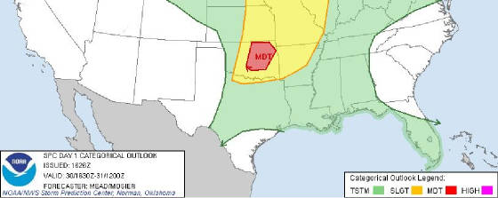 There is another chance for severe weather on Friday as well but for now, stay focused on this
afternoon and evening.
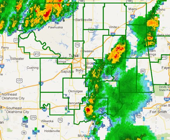
Flash Flood Watch Issued for NE OK Until Saturday Afternoon THE NATIONAL WEATHER SERVICE IN TULSA HAS ISSUED A
* FLASH FLOOD WATCH FOR PORTIONS OF NORTHWEST ARKANSAS
AND OKLAHOMA...
INCLUDING THE FOLLOWING AREAS...IN NORTHWEST ARKANSAS...BENTON...CARROLL...MADISON AND WASHINGTON.
IN OKLAHOMA...ADAIR...CHEROKEE...CRAIG...CREEK...DELAWARE... MAYES...MCINTOSH...MUSKOGEE...NOWATA...OKFUSKEE...OKMULGEE...
OSAGE...OTTAWA...PAWNEE...ROGERS...TULSA...WAGONER AND WASHINGTON.
* THROUGH SATURDAY AFTERNOON *
WIDESPREAD RAINFALL AMOUNTS OF 3 TO 6 INCHES ARE LIKELY ACROSS MUCH OF NORTHEAST OKLAHOMA AND NORTHWEST ARKANSAS THROUGH
SATURDAY MORNING WITH LOCALLY HIGHER AMOUNTS OF 8 TO 10 INCHES POSSIBLE.
THIS WOULD LIKELY LEAD TO LIFE THREATENING
FLASH FLOODING IN SOME AREAS IF THESE RAINFALL AMOUNTS ARE REALIZED. SEVERAL ROUNDS OF HEAVY RAINFALL WILL BE POSSIBLE
WITH THE MOST SIGNIFICANT FLOODING THREAT OCCURRING FRIDAY NIGHT INTO SATURDAY MORNING. * THE HEAVY RAINFALL WILL ALSO
CAUSE RAPID RISES ON CREEKS... SMALL STREAMS...AND EVENTUALLY LEAD TO MAIN-STEM RIVER FLOODING AS WELL.
PRECAUTIONARY/PREPAREDNESS ACTIONS... A FLASH FLOOD WATCH MEANS RAPIDLY RISING WATER OR FLOODING IS POSSIBLE
WITHIN THE WATCH AREA.
IF YOU ARE IN THE WATCH AREA...KEEP INFORMED...AND BE READY FOR QUICK ACTION IF FLASH
FLOODING IS OBSERVED OR IF A WARNING IS ISSUED.
DO NOT DRIVE YOUR VEHICLE INTO AREAS WHERE WATER COVERS THE ROAD
TO UNKNOWN DEPTHS. TAKE A DIFFERENT ROUTE TO REACH YOUR DESTINATION OR WAIT UNTIL THE WATER RECEDES. STAY
TUNED
TO NOAA WEATHER RADIO...COMMERCIAL RADIO OR TELEVISION FOR THE LATEST INFORMATION CONCERNING THIS FLOODING EVENT. ADDITIONAL
WEATHER INFORMATION CAN ALSO BE FOUND AT: WEATHER.GOV/TULSA.
Severe Weather Expected This Afternoon and EveningThere is a risk of severe weather today and tonight across all of NE OK. The primary threat time will be from mid afternoon
through midnight. Storms are expected to fire off the dryline west of Tulsa and track east. Large hail, damaging
winds, and possibly a tornado are possible in eastern OK. The severity of the storms will depend on many factors including
how much dewpoints can increase, how much heating can take place, and where the boundaries from last nights and
this mornings storms are. Please stay tuned to the NWS, local media, and this blog for updates. Here is the NWS
risk graphic for today:  Friday brings yet another chance of severe storms and also a chance of very heavy rain which, with last nights
rain and any rain that falls today will likely result in flooding. A flash Flood Watch will likely be issued at some point
in the next 24 hours for the Friday storms.
Wednesday, May 29, 2013
Tornado Watch Extended East. Tulsa IncludedTHE NATIONAL WEATHER SERVICE HAS EXTENDED TORNADO WATCH 244 TO INCLUDE THE FOLLOWING AREAS UNTIL 11 PM CDT THIS EVENING IN OKLAHOMA THIS WATCH INCLUDES 7 COUNTIES 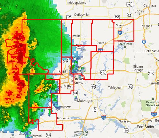 IN NORTHEAST OKLAHOMA CRAIG
MAYES NOWATA
OTTAWA ROGERS
TULSA WASHINGTON
THIS INCLUDES THE CITIES OF...BARTLESVILLE...CLAREMORE...MIAMI... NOWATA...PRYOR...TULSA AND VINITA.
Tornado Watch Issued West of Highway 75 Until 11PMTHE NATIONAL WEATHER SERVICE HAS ISSUED TORNADO WATCH 244 IN EFFECT UNTIL 11 PM CDT THIS EVENING FOR THE FOLLOWING AREAS IN OKLAHOMA THIS WATCH INCLUDES 4 COUNTIES IN EAST CENTRAL OKLAHOMA OKFUSKEE
IN NORTHEAST OKLAHOMA CREEK
OSAGE PAWNEE
THIS INCLUDES THE CITIES OF...BRISTOW...OKEMAH... PAWHUSKA AND PAWNEE. 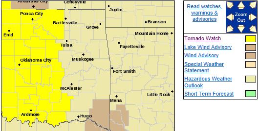
Severe Storms Remain Possible This EveningAs the newer model runs come in, it is looking more likely that thunderstorms will impact the area this evening, mainly after
6:00pm.
The severe threat should be large hail and damaging winds with an isolated tornado possible mainly west
of highway 75. The overall threat with the line of storms will decline as they move east.
Thursday afternoon has
the potential to be very stormy with damaging winds, very large hail to the size of baseballs, and tornado's, some possibly
large so stay tuned...
Wed, May 29, 2013 | link
Severe Weather Possible TonightThere is a risk of severe weather tonight across NE OK, mainly after 6:00PM. Large hail, damaging winds, and possibly a tornado
are possible. The largest severe threat is mainly along and west of I35 where an SPC Moderate Risk Area exists. The storms
are expected to weaken as they move east into the late evening or overnight hours but another complex is shown developing
to the SW of Tulsa and moving into the Tulsa area by 6:00. This will need to be watched to see if it forms and how
well it establishes its self if it does. Thursday currently is listed as a Slight Risk day by the SPC but the ingredients
for a possible significant severe weather outbreak could be in place across NE Oklahoma. This will need to be watched carefully
and a higher risk could be placed on NE OK by the SPC for Thursday by late tonight. Here are the Tulsa NWS risk
maps for today and tomorrow and further updates will be posted today. 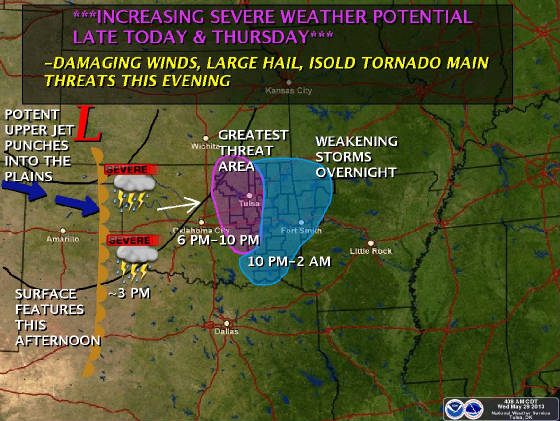 Below is Thursday's graphic. The positioning of the outflow boundary just north of Tulsa is
one factor in where the most severe weather will occur and how severe it is. 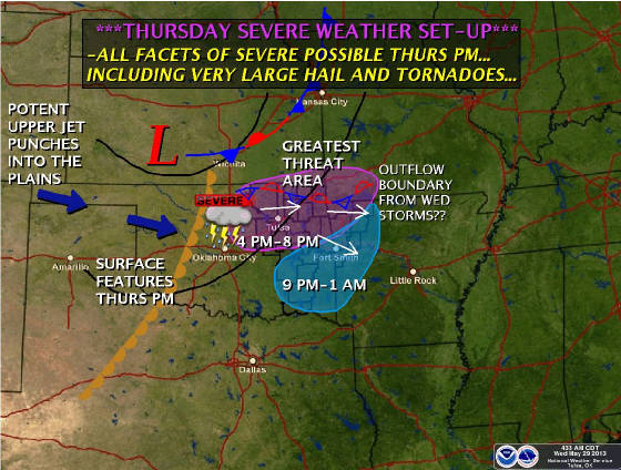
Tuesday, May 28, 2013
Severe Weather Possible Tonight Through ThursdayTonight, there is a slight risk of severe weather, mainly along the Kansas border. All of the area could see thunderstorms
with hail, high winds, and heavy rain possible south of Tulsa this morning and after 7:00PM for the entire area. Here is the SPC risk map for tonight: 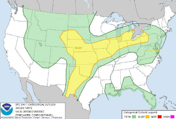 Wednesday shows an increasing severe weather threat with the greatest chances just west and north of Tulsa but
large hail, damaging winds, and tornados are possible at this time. The best chances for severe storms on Wednesday appears
to be between 7PM and midnight. Here is the Tulsa NWS risk map for Wednesday: 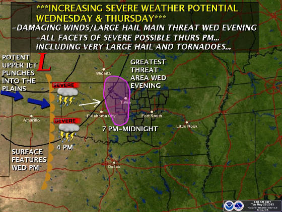 The risk area for Thursday includes all of NE Oklahoma all modes of severe weather. Here is the Tulsa NWS risk
map for Thursday which shows very large hail, damaging winds, and tornados all possibly Thursday evening. 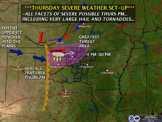 Updates to follow later today for tonights risk.
Tuesday, May 21, 2013
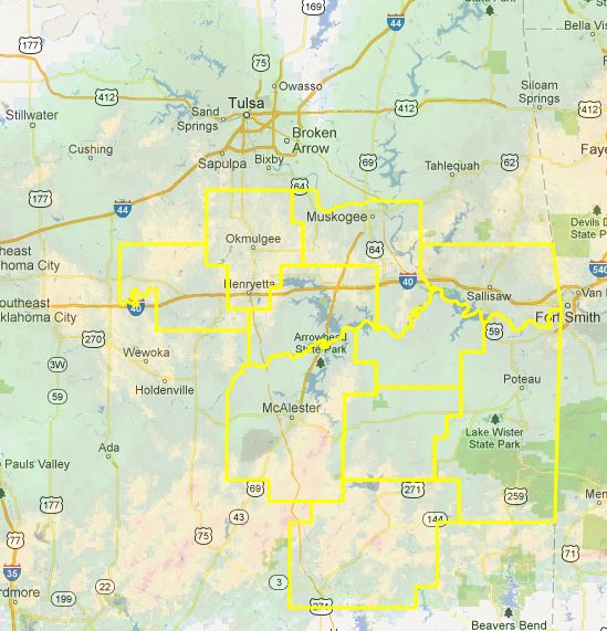
Severe Thunderstorm Watch Issued for Parts of NE OK Until 7PMTHE NATIONAL WEATHER SERVICE HAS ISSUED SEVERE THUNDERSTORM WATCH
202 IN EFFECT UNTIL 7 PM CDT THIS EVENING
FOR THE FOLLOWING AREAS
IN OKLAHOMA THIS WATCH INCLUDES 10 COUNTIES
IN EAST CENTRAL OKLAHOMA
MUSKOGEE OKFUSKEE
SEQUOYAH
IN NORTHEAST OKLAHOMA
OKMULGEE
IN SOUTHEAST OKLAHOMA
HASKELL LATIMER
LE FLORE
MCINTOSH
PITTSBURG PUSHMATAHA
THIS INCLUDES THE CITIES OF...ANTLERS...CLAYTON...EUFAULA...
MCALESTER...MUSKOGEE...OKEMAH...OKMULGEE...POTEAU...SALLISAW...
STIGLER AND WILBURTON
Monday, May 20, 2013
Flash Flood Watch Issued for All of NE OK...FLASH FLOOD WATCH IN EFFECT FROM 7 PM CDT THIS EVENING THROUGH TUESDAY MORNING... THE NATIONAL WEATHER
SERVICE IN TULSA HAS ISSUED A * FLASH FLOOD WATCH FOR A PORTION OF NORTHEAST OKLAHOMA... INCLUDING
THE FOLLOWING AREAS...CRAIG...CREEK...NOWATA... OSAGE...PAWNEE...ROGERS...TULSA AND WASHINGTON...ADAIR...CHEROKEE...DELAWARE...
HASKELL...LATIMER...LE FLORE...MAYES...MCINTOSH...MUSKOGEE... OKFUSKEE...OKMULGEE...OTTAWA...PITTSBURG...SEQUOYAH
AND WAGONER. * FROM 7 PM CDT THIS EVENING THROUGH TUESDAY MORNING * SHOWERS AND
THUNDERSTORMS WILL DEVELOP THIS AFTERNOON AND BECOME MORE WIDESPREAD DURING THE EVENING INTO TONIGHT. THESE STORMS WILL BE CAPABLE OF PRODUCING VERY HEAVY RAINFALL...WITH LOCAL AMOUNTS OF 3 TO 4 INCHES POSSIBLE. THE
THREAT OF HEAVIEST RAIN IS EXPECTED TO SHIFT SOUTH OF INTERSTATE 44 BY EARLY TUESDAY MORNING. * THE HEAVY RAINFALL MAY LEAD TO LOCALIZED FLASH FLOODING...AS WELL AS RAPID RISES ON AREA CREEKS AND
SMALL STREAMS. 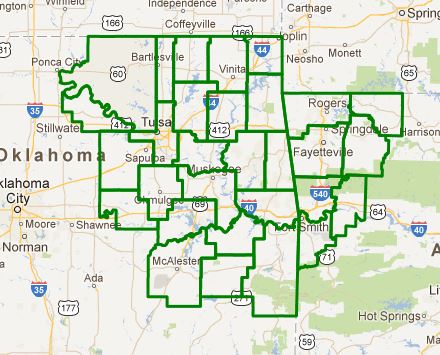
Tornado Watch Issued until 10:00PM for all of NE OKTORNADO WATCH 191 IS IN EFFECT UNTIL 1000 PM CDT FOR THE FOLLOWING LOCATIONS OKC001-005-013-015-017-019-021-023-027-029-031-033-035-037-041- 049-051-061-063-067-069-071-073-077-079-081-083-085-087-091-095- 097-099-101-103-105-107-109-111-113-115-117-119-121-123-125-127- 131-133-135-137-141-143-145-147-210300- /O.NEW.KWNS.TO.A.0191.130520T1810Z-130521T0300Z/ 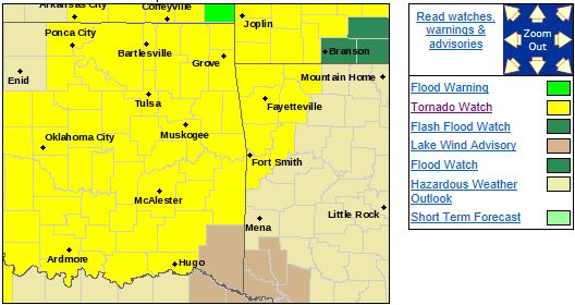 OK . OKLAHOMA COUNTIES INCLUDED ARE ADAIR
ATOKA BRYAN CADDO
CANADIAN CARTER CHEROKEE
CHOCTAW CLEVELAND COAL
COMANCHE COTTON CRAIG
CREEK DELAWARE GARVIN
GRADY HASKELL HUGHES
JEFFERSON JOHNSTON KAY
KINGFISHER LATIMER LE FLORE
LINCOLN LOGAN LOVE
MARSHALL MAYES MCCLAIN
MCINTOSH MURRAY MUSKOGEE
NOBLE NOWATA OKFUSKEE
OKLAHOMA OKMULGEE OSAGE
OTTAWA PAWNEE PAYNE
PITTSBURG PONTOTOC POTTAWATOMIE
PUSHMATAHA ROGERS SEMINOLE
SEQUOYAH STEPHENS TILLMAN
TULSA WAGONER WASHINGTON $$
Primary Threat Area Looking to be South of I44 and North of I40Hail to the size of baseballs, damaging winds, and tornados, including large and long track tornados are all possible. Severe storms are likely across all of NE Oklahoma despite the highlight on the area between I44 and
I40. Here is the NWS tornado warning probability map for today. Higher numbers = greater
chances: 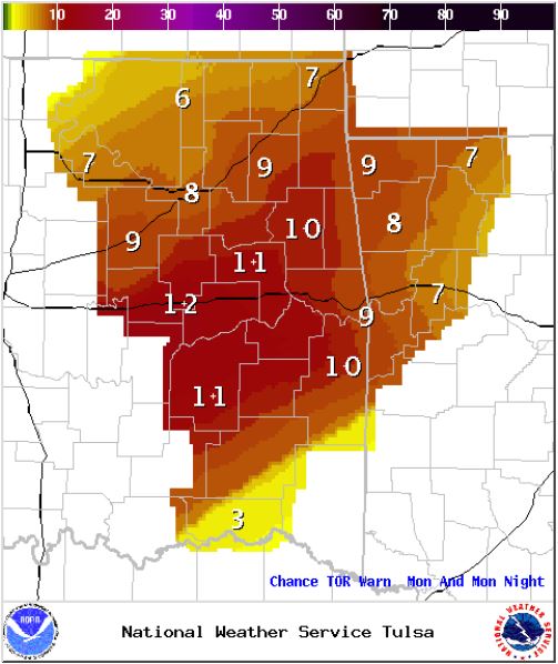 There is also a flash flood threat present with 1-2 inches of rain possible across most of
NE OK with amounts greater than 4 inches possible between I44 and I40. There is also a flash flood threat present with 1-2 inches of rain possible across most of
NE OK with amounts greater than 4 inches possible between I44 and I40.As the evening progresses and into
the overnight hours, flash fooding could become a concern. A Flood Watch has been issued for the Illinois River due to
the expected rainfall. Here is the NWS expected rainfall through late this evening: 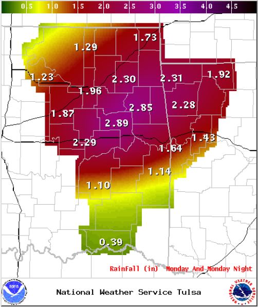 From a flood perspective, here is the NWS max rainfall map through Thursday. 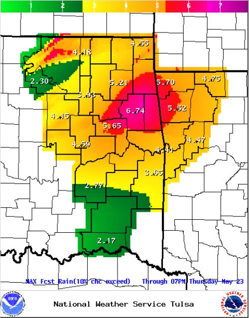 The next update will likely be with the first tornado watch that is issued. The next update will likely be with the first tornado watch that is issued.
Severe Weather Expected This Afternoon into the EveningHere is a map with some more refined timing. It appears that storms will initiate west of Tulsa by 2:00PM impacting Tulsa
as early as 4:00PM. Updates to follow... 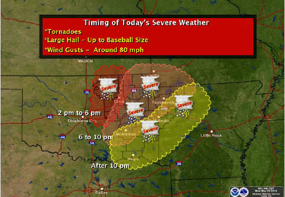
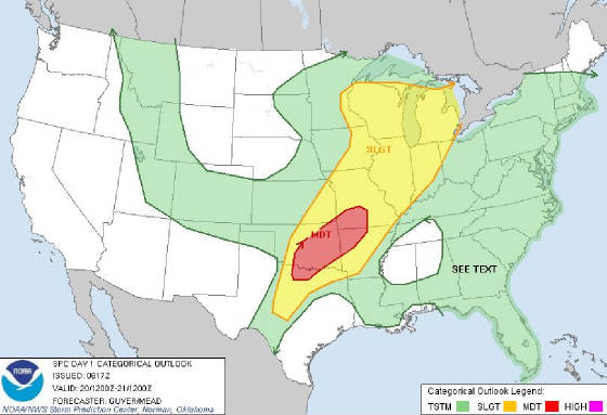
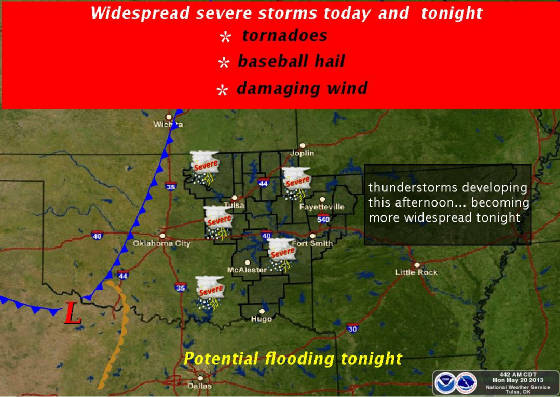
Severe Weather Likely Today and TonightSevere storms are again expected to form around 3:00 and quickly become severe. Large hail, damaging winds, tornados, and
tonight, flash flooding is expected.
Here are the SPC and NWS risk maps for today.
Sunday, May 19, 2013
Tornado Watch Issued Until 6:00AM for NE OKTHE NATIONAL WEATHER SERVICE HAS ISSUED TORNADO WATCH 188 UNTIL 6 AM CDT MONDAY WHICH REPLACES A PORTION OF TORNADO WATCH
182. THE NEW WATCH IS VALID FOR THE FOLLOWING AREAS IN OKLAHOMA THE NEW WATCH INCLUDES 20 COUNTIES 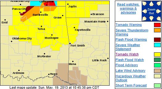 IN EAST CENTRAL OKLAHOMA CHEROKEE
MUSKOGEE OKFUSKEE
SEQUOYAH IN NORTHEAST OKLAHOMA ADAIR CRAIG
CREEK DELAWARE
MAYES NOWATA
OKMULGEE OSAGE
OTTAWA PAWNEE
ROGERS TULSA
WAGONER WASHINGTON
IN SOUTHEAST OKLAHOMA HASKELL
MCINTOSH THIS INCLUDES THE CITIES
OF...BARTLESVILLE...BRISTOW... CLAREMORE...EUFAULA...JAY...MIAMI...MUSKOGEE...NOWATA...OKEMAH... OKMULGEE...PAWHUSKA...PAWNEE...PRYOR...SALLISAW...STIGLER... STILWELL...TAHLEQUAH...TULSA...VINITA AND WAGONER. $$
Tornado Watch Issued for All of Eastern OK Until 11:00PM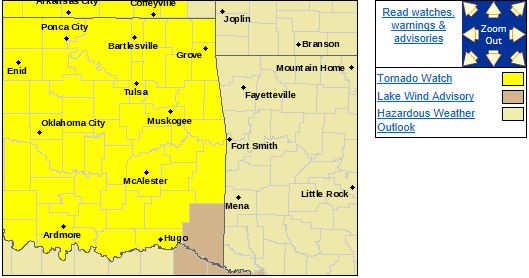 TORNADO WATCH 182 IS IN EFFECT UNTIL 1100 PM CDT FOR THE FOLLOWING LOCATIONS . OKLAHOMA
COUNTIES INCLUDED ARE ADAIR
ATOKA BRYAN CADDO
CANADIAN CARTER CHEROKEE
CHOCTAW CLEVELAND COAL
COMANCHE COTTON CRAIG
CREEK DELAWARE GARFIELD
GARVIN GRADY GRANT
HASKELL HUGHES JEFFERSON
JOHNSTON KAY KINGFISHER
LATIMER LE FLORE LINCOLN
LOGAN LOVE MARSHALL
MAYES MCCLAIN MCINTOSH
MURRAY MUSKOGEE NOBLE
NOWATA OKFUSKEE OKLAHOMA
OKMULGEE OSAGE OTTAWA
PAWNEE PAYNE PITTSBURG
PONTOTOC POTTAWATOMIE PUSHMATAHA
ROGERS SEMINOLE SEQUOYAH
STEPHENS TULSA WAGONER
WASHINGTON $$
Significant Severe Weather Outbreak Expected Today
Sun, May 19, 2013 | link
Saturday, May 18, 2013
Severe Thunderstorm Watch Issued for Parts of NE OK until 3 AMTHE NATIONAL WEATHER SERVICE HAS ISSUED SEVERE THUNDERSTORM WATCH 177 IN EFFECT UNTIL 3 AM CDT SUNDAY FOR THE FOLLOWING
AREAS IN OKLAHOMA THIS WATCH INCLUDES 12 COUNTIES IN EAST CENTRAL OKLAHOMA OKFUSKEE
IN NORTHEAST OKLAHOMA CRAIG
CREEK MAYES
NOWATA OKMULGEE
OSAGE PAWNEE
ROGERS TULSA
WAGONER WASHINGTON
THIS INCLUDES THE CITIES OF...BARTLESVILLE...BRISTOW... CLAREMORE...NOWATA...OKEMAH...OKMULGEE...PAWHUSKA...PAWNEE... PRYOR...TULSA...VINITA AND WAGONER. 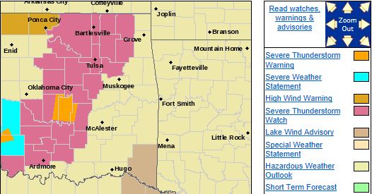
Thunderstorms Possible Late Tonight. Very Severe Storms Likely Sunday NightThere is a light to moderate change of thunderstorms tonight across parts of NE OK with large hail and damaging winds being
the primary threat. Very severe thunderstorms are expected Sunday evening with damaging winds, baseball size hail,
and tornadoes, some possibly violent in the Tulsa area as early 8:00pm. Updates in the morning but here is
a Tulsa NWS graphic from tonight. 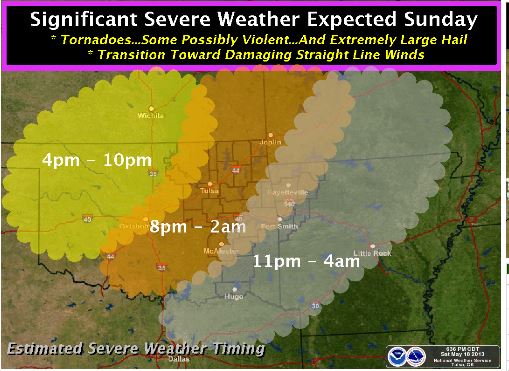
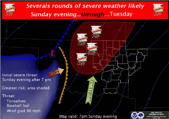
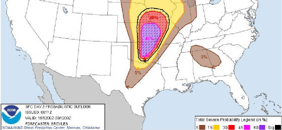
Multiple Rounds of Significant Severe Weather Possible Sunday-MondayCurrently the risk focus is on Sunday evening where most of central and eastern Oklahoma will be in the higher risk area.
Damaging winds, hail to the size of baseballs, and tornados are possible during this time frame. Monday introduces locally
heavy rain as an additional hazard.
Below are the current Tulsa NWS risk map and the SPC risk map for Sunday. NE
Oklahoma seems to be most likely impacted after 3:00PM on Sunday.
Thursday, May 16, 2013
Severe Weather Expected Sunday Evening Through Monday EveningA heads up for what appears to be a potential severe weather outbreak for Oklahoma heading into the work week. 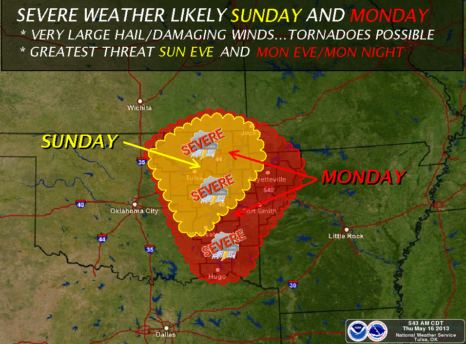
Thursday, May 9, 2013
There is a Slight Risk of Severe Weather This EveningThe slight risk area includes most of NE Oklahoma. Heavy rain, large hail, and damaging winds are the primary threats. Here is the SPC risk area: 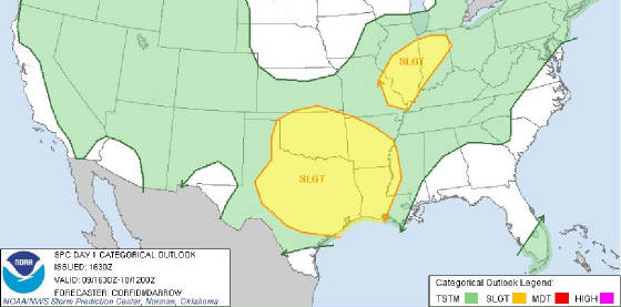
Thursday, May 2, 2013
Freeze Warning and Winter Weather Advisory IssuedWINTER WEATHER ADVISORY IN EFFECT FROM 1 AM TO 1 PM CDT FRIDAY... THE NATIONAL WEATHER SERVICE IN TULSA HAS ISSUED
A WINTER WEATHER ADVISORY FOR SNOW AND SLEET...WHICH IS IN EFFECT FROM 1 AM TO 1 PM CDT FRIDAY... FOR
THE FOLLOWING COUNTIES... * IN OKLAHOMA...OTTAWA AND DELAWARE. IN ARKANSAS...BENTON... WASHINGTON...CARROLL
AND MADISON. HAZARDOUS WEATHER... * RAIN WILL MIX WITH OR CHANGE OVER TO SNOW THIS EVENING AND
TONIGHT ACROSS NORTHEAST OKLAHOMA AND NORTHWEST ARKANSAS AS AN UNSEASONABLY COLD UPPER LOW DEEPENS OVER
THE AREA. THIS SHOULD ALLOW TEMPERATURES TO COOL OFF ENOUGH THROUGH THE EVENING FOR SNOW
TO DEVELOP WITHIN HEAVIER BANDS OF PRECIPITATION. * LOCAL SNOW ACCUMULATIONS 1 TO 2 INCHES ARE POSSIBLE TONIGHT. MOST IF NOT ALL ACCUMULATIONS WILL BE CONFINED TO GRASSY AND ELEVATED SURFACES. IT IS ALSO
LIKELY THAT ACCUMULATIONS WILL VARY CONSIDERABLY OVER RELATIVELY SHORT DISTANCES. IMPACTS... * ACCUMULATING SNOW ON TREES THAT HAVE LEAFED OUT COULD BE ENOUGH TO CAUSE LIMBS TO BE BROUGHT DOWN BY
THE WEIGHT OF THE SNOW. THIS CAN POTENTIALLY CAUSE POWER OUTAGES IN A FEW AREAS. A FEW
BRIDGES OR OVERPASSES MAY BECOME SLICK DURING HEAVIER PERIODS OF SNOW...ESPECIALLY AT HIGHER ELEVATIONS
IN NORTHWEST ARKANSAS. DEFINITION... * A WINTER WEATHER ADVISORY MEANS THAT WINTERY PRECIPITATION
MAY ACCUMULATE ON ROADWAYS. PRECAUTIONARY/PREPAREDNESS ACTIONS... * USE EXTRA CAUTION
IF DRIVING. 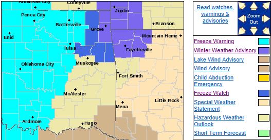 FREEZE WARNING IN EFFECT FROM 1 AM TO 10 AM CDT FRIDAY... THE NATIONAL WEATHER SERVICE IN TULSA HAS
ISSUED A FREEZE WARNING...WHICH IS IN EFFECT FROM 1 AM TO 10 AM CDT FRIDAY... FOR THE FOLLOWING COUNTIES... * IN OKLAHOMA...WASHINGTON...PAWNEE...NOWATA...CREEK...OKFUSKEE... OKMULGEE...TULSA...ROGERS AND
OSAGE. * THIS REPLACES THE WATCH THAT WAS IN EFFECT. HAZARDOUS WEATHER... * PARTIALLY CLEARING
SKIES TONIGHT WILL ALLOW TEMPERATURES TO DROP TO NEAR OR SLIGHTLY BELOW FREEZING...ESPECIALLY IN AREAS WEST OF U.S. HIGHWAY 75 INCLUDING PARTS OF THE TULSA METROPOLITAN AREA. IMPACTS... * THESE CONDITIONS WILL KILL PLANTS AND OTHER TENDER VEGETATION THAT ARE LEFT OUTDOORS OR UNPROTECTED. DEFINITION... * A FREEZE WARNING MEANS FREEZING TEMPERATURES WILL OCCUR. PRECAUTIONARY/PREPAREDNESS
ACTIONS... * IF YOU HAVE PLANTS...SMALL TREES OR OTHER TENDER VEGETATION WHICH COULD BE HARMED BY
A FREEZE...TAKE THE TIME NOW TO PROTECT THEM. POTTED PLANTS NORMALLY LEFT OUTDOORS SHOULD BE
COVERED OR BROUGHT INSIDE AWAY FROM THE COLD.
Freeze Watch Area Expanded; Rain/Snow Mix Expected OvernightTHE NATIONAL WEATHER SERVICE IN TULSA HAS ISSUED A FREEZE WATCH... WHICH IS IN EFFECT FROM LATE TONIGHT THROUGH FRIDAY
MORNING AND ALSO FROM LATE FRIDAY NIGHT THROUGH SATURDAY MORNING... FOR THE FOLLOWING COUNTIES... * IN OKLAHOMA...OTTAWA...DELAWARE...CHEROKEE...ADAIR...WAGONER AND MAYES. *
IN ARKANSAS...BENTON...WASHINGTON...CARROLL AND MADISON. 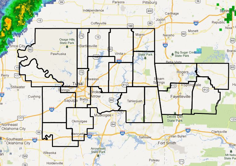 HAZARDOUS WEATHER... * OVERNIGHT LOW TEMPERATURES BOTH TONIGHT AND FRIDAY NIGHT WILL APPROACH
FREEZING...ESPECIALLY WITHIN THE COLDER VALLEYS. THE DURATION OF ANY FREEZING TEMPERATURES IS LIKELY TO
BE ONLY FOR A FEW HOURS EACH NIGHT. IMPACTS... * THESE CONDITIONS COULD KILL TENDER VEGETATION
THAT ARE LEFT OUTDOORS OR UNPROTECTED. DEFINITION... * A FREEZE WATCH MEANS FREEZING TEMPERATURES
ARE POSSIBLE. PRECAUTIONARY/PREPAREDNESS ACTIONS... * PRECAUTIONS SHOULD ALSO BE TAKEN TO PROTECT SMALL PLANTS
AND TENDER VEGETATION. A Rain/Snow mix is expected late tonight into Friday morning with
little to know accumulations expected at this time.
Wednesday, May 1, 2013
Special Weather Statement from the NWS Concerning Snow PotentialAN UNPRECEDENTED LATE SEASON SNOWFALL IS FORECAST FOR
NORTHEAST OKLAHOMA AND POSSIBLY NORTHWEST ARKANSAS LATE THURSDAY
INTO FRIDAY...
AN UNSEASONABLY STRONG COLD FRONT...CURRENTLY LOCATED FROM NORTH-
CENTRAL TO SOUTHWEST
OKLAHOMA WILL SWEEP SOUTHEAST ACROSS THE
REGION TONIGHT INTO THURSDAY MORNING. MUCH COLDER AIR WILL FILTER
INTO
THE REGION BEHIND THE FRONT...WITH TEMPERATURES FALLING BACK
INTO THE 40S AND EVEN 30S BY THE END OF THE DAY THURSDAY
IN SOME
AREAS. THE MAIN UPPER TROUGH WILL LAG BEHIND THE ADVANCING
FRONT...WHICH WILL PROVIDE LIFT TO PRODUCE PRECIPITATION
BACK IN
THE COLD AIR BEHIND THE FRONT. THE LATEST DATA SUGGESTS THAT NEAR
SURFACE TEMPS WILL GET COLD ENOUGH TO
ALLOW FOR THE PRECIP TO MIX
WITH OR CHANGE OVER TO SNOW IN NORTHEAST OKLAHOMA BY LATE IN THE
DAY ON THURSDAY AND
POSSIBLY EVEN INTO NORTHWEST ARKANSAS BY LATE
THURSDAY NIGHT. IF THIS CHANGE OVER DOES INDEED OCCUR...THE SNOW
COULD
BE HEAVY AT TIMES THURSDAY NIGHT INTO FRIDAY MORNING WITH
SOME LIGHT ACCUMULATION OF UP TO AN INCH POSSIBLE MAINLY ON
GRASSY
OR ELEVATED SURFACES NORTH OF HIGHWAY 412. ANOTHER CONCERN IS THAT
SNOW COULD ACCUMULATE ON FULLY LEAFED
TREES...WHICH...COMBINED
WITH THE STRONG NORTH WINDS BEHIND THE FRONT...COULD CAUSE LIMBS
TO BREAK. THIS IN TURN
COULD LEAD TO POWER OUTAGES WHERE THE SNOW
IS THE HEAVIEST. ROADWAYS WILL LIKELY REMAIN WET DUE TO THE WARM
ROAD
TEMPERATURES...BUT COULD TEMPORARILY BECOME SLUSHY IF THE
SNOW FALLS HEAVY ENOUGH.
STAY TUNED TO THE LATEST
FORECASTS AND STATEMENTS AS THIS
EXTREMELY RARE EVENT UNFOLDS.
Wed, May 1, 2013 | link
Freeze Watch Issue for Parts of NE OklahomaTHE NATIONAL WEATHER SERVICE IN TULSA HAS ISSUED A FREEZE WATCH...
WHICH IS IN EFFECT FROM LATE THURSDAY NIGHT THROUGH
FRIDAY
MORNING...
FOR THE FOLLOWING COUNTIES...
* IN OKLAHOMA...PAWNEE...WASHINGTON...OSAGE...CRAIG...NOWATA...
CREEK...OKFUSKEE...OKMULGEE...TULSA AND ROGERS. 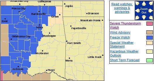
HAZARDOUS WEATHER...
* AN UNSEASONABLY STRONG COLD FRONT WILL MOVE THROUGH THE AREA
TONIGHT...WITH
TEMPERATURES POTENTIALLY FALLING NEAR FREEZING
IN PARTS OF NORTHEAST OKLAHOMA BY EARLY FRIDAY MORNING. AT
THE
PRESENT TIME...IT APPEARS CLOUD COVER WILL REMAIN THICK ENOUGH
TO KEEP TEMPERATURES
JUST ABOVE THE FREEZING MARK. SHOULD SKIES
CLEAR FASTER THAN CURRENT FORECASTS INDICATE...THE LIKELIHOOD
OF TEMPERATURES DROPPING BELOW FREEZING WILL INCREASE
SIGNIFICANTLY.
IMPACTS...
* THESE CONDITIONS COULD KILL PLANTS AND AND OTHER TENDER
VEGETATION THAT ARE LEFT OUTDOORS OR UNPROTECTED.
DEFINITION...
* A FREEZE WATCH MEANS FREEZING TEMPERATURES ARE POSSIBLE.
PRECAUTIONARY/PREPAREDNESS
ACTIONS...
* PRECAUTIONS SHOULD BE TAKEN TO PROTECT SMALL PLANTS AND TENDER
VEGETATION.
|