|
Friday, April 26, 2013
Severe Thunderstorm Watch Issued South of Tulsa until 4:00amIN OKLAHOMA THIS WATCH INCLUDES 10 COUNTIES IN EAST CENTRAL OKLAHOMA MUSKOGEE
OKFUSKEE IN NORTHEAST OKLAHOMA OKMULGEE IN SOUTHEAST OKLAHOMA CHOCTAW HASKELL
LATIMER LE FLORE
MCINTOSH PITTSBURG
PUSHMATAHA 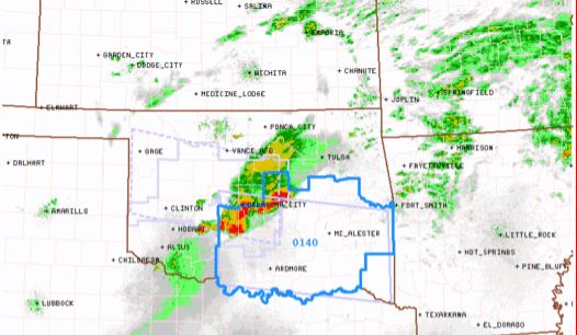
Tuesday, April 23, 2013
Freeze Warning and Frost Advisories IssuedFREEZE WARNING IN EFFECT FROM 1 AM TO 9 AM CDT WEDNESDAY... THE NATIONAL WEATHER SERVICE IN TULSA HAS ISSUED A
FREEZE WARNING...WHICH IS IN EFFECT FROM 1 AM TO 9 AM CDT WEDNESDAY... FOR THE FOLLOWING COUNTIES... * IN OKLAHOMA...WASHINGTON...OTTAWA...PAWNEE...OSAGE...CRAIG AND NOWATA. 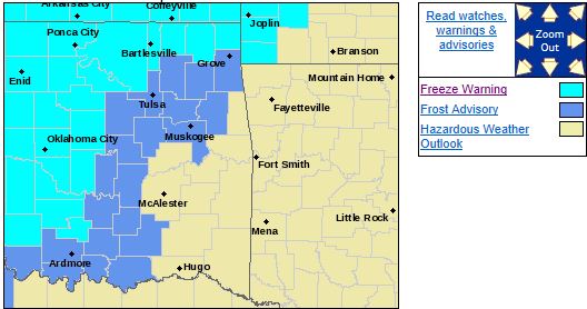 * THE FROST ADVISORY ISSUED EARLIER FOR THIS AREA HAS BEEN UPGRADED TO A FREEZE WARNING. HAZARDOUS WEATHER... * CLEARING LATE TONIGHT IN THE WARNING AREA WILL ALLOW FOR SUB FREEZING
TEMPERATURES BY DAYLIGHT. IMPACTS... * THESE CONDITIONS WILL KILL PLANTS THAT ARE LEFT OUTDOORS
OR UNPROTECTED. DEFINITION... * A FREEZE WARNING MEANS SUB FREEZING TEMPERATURES WILL OCCUR. PRECAUTIONARY/PREPAREDNESS
ACTIONS... * PRECAUTIONS SHOULD ALSO BE TAKEN TO PROTECT PLANTS. FROST ADVISORY NOW IN EFFECT FROM
1 AM TO 9 AM CDT WEDNESDAY... THE NATIONAL WEATHER SERVICE IN TULSA HAS ADJUSTED THE TIMING OF THE FROST ADVISORY
AND IT IS NOW IN EFFECT FROM 1 AM TO 9 AM CDT WEDNESDAY... FOR THE FOLLOWING COUNTIES... * IN
OKLAHOMA...WAGONER...CREEK...OKFUSKEE...OKMULGEE... MUSKOGEE...TULSA...ROGERS...MAYES AND DELAWARE. HAZARDOUS WEATHER... * CLEARING LATE TONIGHT IN THE ADVISORY AREA WILL ALLOW FOR FROST TO FORM BY
DAYLIGHT. IMPACTS... * SENSITIVE OUTDOOR PLANTS MAY BE KILLED IF LEFT UNPROTECTED FROM
THE COLD. PRECAUTIONARY/PREPAREDNESS ACTIONS... * COVER OUTDOOR PLANTS OR BRING THEM INDOORS
Monday, April 22, 2013
There is a slight Risk of Severe Weather Today and TonightThe slight risk area is mainly NW of Tulsa but all of NE OK could see a chance of large hail, damaging winds, and
an isolated tornado if storms develop this afternoon. All of NE OK can expect much cooler temps Wednesday morning
with frost possible in some areas. Here is the Tulsa NWS risk map for today: 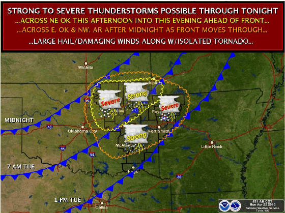
Thursday, April 18, 2013
Freeze Warning for Parts of NE Oklahoma, Including Tulsa...FREEZE WARNING IN EFFECT FROM 1 AM TO 10 AM CDT FRIDAY...
THE NATIONAL WEATHER SERVICE IN TULSA HAS ISSUED A
FREEZE
WARNING...WHICH IS IN EFFECT FROM 1 AM TO 10 AM CDT FRIDAY...
FOR THE FOLLOWING COUNTIES...
* IN OKLAHOMA...PAWNEE...WASHINGTON...OSAGE...CRAIG...NOWATA...
CREEK...TULSA AND ROGERS.
HAZARDOUS
WEATHER...
* TEMPERATURES WILL DROP TO NEAR AND BELOW FREEZING LATE TONIGHT
AND EARLY TOMORROW MORNING
ACROSS PORTIONS OF NORTHEAST
OKLAHOMA TO THE NORTHWEST OF A LINE FROM BRISTOW TO VINITA.
THIS IS A VERY LATE SEASON FREEZE FOR MUCH OF THIS PART OF
NORTHEAST OKLAHOMA...AND TEMPERATURES WILL BE
NEAR RECORD LOWS.
ALTHOUGH TULSA COUNTY IS INCLUDED IN THE FREEZE WARNING...MOST
OF THE
TULSA METRO AREA ITSELF WILL NOT EXPERIENCE WIDESPREAD
FREEZING TEMPERATURES...WITH MORE RURAL AREAS OF
THE COUNTY
BEING MOST SUSCEPTIBLE.
IMPACTS...
* THESE CONDITIONS WILL KILL PLANTS AND OTHER
TENDER VEGETATION
THAT ARE LEFT OUTDOORS OR UNPROTECTED.
DEFINITION...
* A FREEZE WARNING
MEANS FREEZING TEMPERATURES WILL OCCUR.
PRECAUTIONARY/PREPAREDNESS ACTIONS...
* PRECAUTIONS SHOULD ALSO BE
TAKEN TO PROTECT SMALL PLANTS AND
TENDER VEGETATION.
Thu, April 18, 2013 | link
Wednesday, April 17, 2013
Flash Flood Watch Issued in addition to the Tornado WatchFLASH FLOOD WATCH IN EFFECT THROUGH THURSDAY MORNING... THE NATIONAL WEATHER SERVICE IN TULSA HAS ISSUED A * FLASH FLOOD WATCH FOR PORTIONS OF EAST CENTRAL OKLAHOMA AND NORTHEAST OKLAHOMA...INCLUDING THE FOLLOWING
AREAS...IN EAST CENTRAL OKLAHOMA...OKFUSKEE. IN NORTHEAST OKLAHOMA...CRAIG... CREEK...DELAWARE...MAYES...NOWATA...OKMULGEE...OSAGE...
OTTAWA...PAWNEE...ROGERS...TULSA...WAGONER AND WASHINGTON. 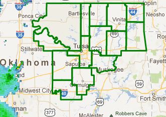 * THROUGH THURSDAY MORNING. * WIDESPREAD RAINFALL AMOUNTS OF 2 TO 3 INCHES WILL BE POSSIBLE
THROUGH EARLY THURSDAY MORNING...GENERALLY ALONG AND NORTH OF THE INTERSTATE 44 CORRIDOR IN NORTHEAST OKLAHOMA.
TWO ROUNDS OF RAINFALL WILL BE POSSIBLE...THE FIRST BEING THE POTENTIAL FOR TRAINING THUNDERSTORMS
ALONG A STATIONARY FRONT STRETCHED ACROSS THE AREA THIS AFTERNOON AND EVENING. THE SECOND ROUND OF
RAINFALL IS THE MOST LIKELY...AND WILL ACCOMPANY AN EXPECTED SQUALL LINE AS THE COLD FRONT PUSHES THROUGH THE
REGION TONIGHT. THE ACCUMULATED RAINFALL COULD LEAD TO LOCALIZED FLASH FLOODING. PRECAUTIONARY/PREPAREDNESS
ACTIONS... A FLASH FLOOD WATCH MEANS RAPIDLY RISING WATER OR FLOODING IS POSSIBLE WITHIN THE WATCH AREA. BE ESPECIALLY CAUTIOUS AT NIGHT WHEN IT IS HARDER TO RECOGNIZE THE DANGERS OF FLASH FLOODS. IF FLASH FLOODING
IS OBSERVED...ACT QUICKLY. DO NOT STAY IN AREAS SUBJECT TO FLOODING WHEN WATER BEGINS TO RISE. MOTORISTS SHOULD
NOT DRIVE THROUGH WATER OF UNKNOWN DEPTH. TAKE A DIFFERENT ROUTE TO REACH YOUR DESTINATION OR WAIT UNTIL THE WATER
RECEDES.
Tornado Watch Issued for Most of NE OK Including Tulsa Until 11:00PMTHE NATIONAL WEATHER SERVICE HAS ISSUED TORNADO WATCH 116 IN EFFECT UNTIL 11 PM CDT THIS EVENING FOR THE FOLLOWING AREAS IN OKLAHOMA THIS WATCH INCLUDES 17 COUNTIES IN EAST CENTRAL OKLAHOMA CHEROKEE
MUSKOGEE OKFUSKEE
IN NORTHEAST OKLAHOMA CRAIG
CREEK DELAWARE
MAYES NOWATA
OKMULGEE OSAGE
OTTAWA PAWNEE
ROGERS TULSA
WAGONER WASHINGTON
IN SOUTHEAST OKLAHOMA MCINTOSH
THIS INCLUDES THE CITIES OF...BARTLESVILLE...BRISTOW... CLAREMORE...EUFAULA...JAY...MIAMI...MUSKOGEE...NOWATA...OKEMAH... OKMULGEE...PAWHUSKA...PAWNEE...PRYOR...TAHLEQUAH...TULSA... VINITA AND WAGONER. 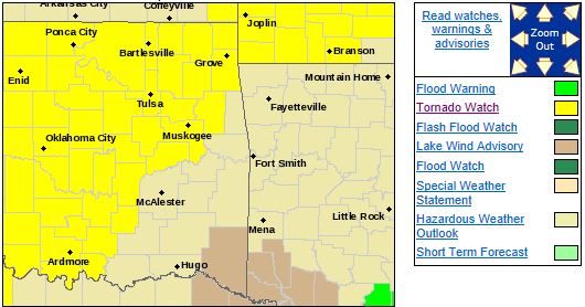
Risk of Severe Weather Remains, Tornado Probabilities IncreasedThe latest SPC forecast has been modified to include a wider area for tornado risk. This area extends from SW Oklahoma NE
in OKC, and along I44 into Missouri. Here is the latest tornado risk map from the SPC: 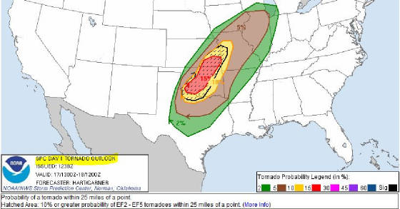 This change also includes a decrease in the possibility of severe storms until this evening. Discrete
supercells are expected to form in NW Texas/SW OK and track NE into NE Oklahoma this evening. Very large hail and
tornados are the primary risks with a possibility of a few strong tornados. After these storms clear the area,
a line of storms is expected to form and swing through the area bringing a risk of damaging winds, large hail, and heavy rain
of 1-2 inches late this evening. In the short term, some thunderstorms are forming across NE OK, especially
along and N of I44. These are not expected to become severe at this time. Updates to follow...
Severe Weather and Heavy Rain Expected Today and TonightThe SPC has placed most of Oklahoma in the moderate risk area for severe weather today. This included risks for large hail,
damaging winds, tornadoes, and heavy rain. The tornado chances in NE Oklahoma are not as great as SW Oklahoma but
any cells that develop and remain discrete in NE Oklahoma could become tornadic. There is a chance of storms developing
over NE Oklahoma this morning then again late this afternoon and they are likely this evening. There remains some model disagreement
so updates will follow. Here is the Tulsa NWS risk map for today. 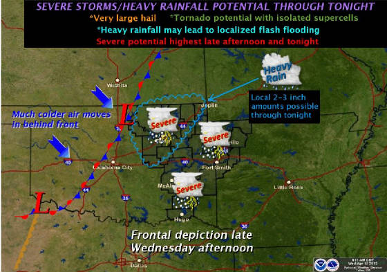
Monday, April 15, 2013
Severe Thunderstorm Watch Issued North of Tulsa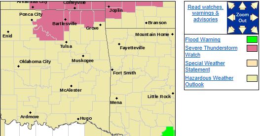 THE NATIONAL WEATHER SERVICE HAS ISSUED SEVERE THUNDERSTORM WATCH 109 IN EFFECT UNTIL 5 AM CDT TUESDAY FOR THE FOLLOWING
AREAS IN OKLAHOMA THIS WATCH INCLUDES 6 COUNTIES IN NORTHEAST OKLAHOMA CRAIG
NOWATA OSAGE
OTTAWA PAWNEE
WASHINGTON THIS INCLUDES THE CITIES OF...BARTLESVILLE...MIAMI...NOWATA... PAWHUSKA...PAWNEE AND VINITA.
Tornado Watch Issued East and SE of Tulsa until 11:00PMIN NORTHEAST OKLAHOMA ADAIR, ELAWARE, MAYES,OKMULGEE, WAGONER.
I SOUTHEAST OKLAHOMA
CHOCTAW, HSKELL, LATIMER , LE FLORE MCINTOSH PITTSBURG PUSHMATAHA
THIS
INCLUDES THE CITIES OF...ANTLERS...BENTONVILLE... BERRYVILLE...CHARLESTON...CLAYTON...EUFAULA...EUREKA SPRINGS... FAYETTEVILLE...FORT
SMITH...HUGO...HUNTSVILLE...JAY...MCALESTER... MUSKOGEE...OKEMAH...OKMULGEE...OZARK...POTEAU...PRYOR...ROGERS... SALLISAW...SPRINGDALE...STIGLER...STILWELL...TAHLEQUAH...
VAN BUREN...WAGONER AND WILBURTON. 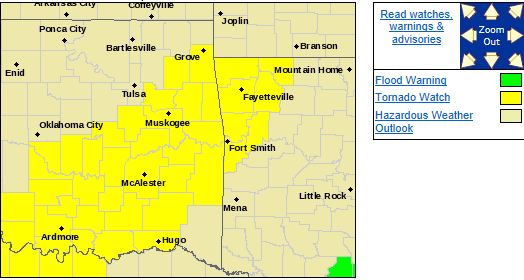 DISCUSSION...SCATTERED INTENSE THUNDERSTORM DEVELOPMENT IS EXPECTED WITHIN THE NEXT COUPLE OF HOURS...NEAR A SURFACE FRONT AND DRYLINE ACROSS EASTERN OKLAHOMA INTO NORTH CENTRAL TEXAS...BEFORE SLOWLY DEVELOPING
NORTHEASTWARD THIS EVENING. LARGE HAIL AND LOCALLYDAMAGING
WIND GUSTS MAY BE THE PRIMARY SEVERE WEATHER THREATSINITIALLY...BUT...BY
EARLY EVENING...THE RISK FOR TORNADOES PROBABLYWILL INCREASE WITH STRONGEST
STORMS.
Sunday, April 14, 2013
Severe Thunderstorm Watch Issued For all of NE OK until 1:00amEFFECTIVE THIS SUNDAY NIGHT AND MONDAY MORNING FROM 710 PM UNTIL
100
AM CDT.
HAIL TO 1.5 INCHES IN DIAMETER...THUNDERSTORM
WIND GUSTS TO 70
MPH...AND DANGEROUS LIGHTNING ARE POSSIBLE IN THESE AREAS. IN EAST CENTRAL OKLAHOMA
CHEROKEE
MUSKOGEE SEQUOYAH
IN NORTHEAST OKLAHOMA
ADAIR
CRAIG CREEK
DELAWARE
MAYES NOWATA
OKMULGEE
OSAGE OTTAWA
PAWNEE
ROGERS TULSA
WAGONER
WASHINGTON
THIS INCLUDES THE CITIES OF...BARTLESVILLE...BRISTOW...
CLAREMORE...JAY...MIAMI...MUSKOGEE...NOWATA...OKMULGEE...
PAWHUSKA...PAWNEE...PRYOR...SALLISAW...STILWELL...TAHLEQUAH...
TULSA...VINITA AND WAGONER.
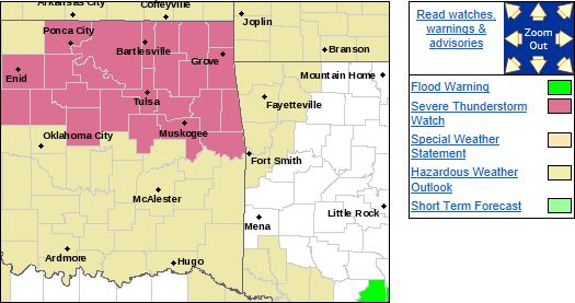
THE SEVERE THUNDERSTORM WATCH AREA IS APPROXIMATELY ALONG AND 85
STATUTE MILES EAST AND WEST OF A LINE FROM 20 MILES NORTHEAST OF
BARTLESVILLE OKLAHOMA TO 50 MILES SOUTHWEST
OF TULSA OKLAHOMA.
FOR A COMPLETE DEPICTION OF THE WATCH
SEE THE ASSOCIATED WATCH
OUTLINE UPDATE (WOUS64 KWNS WOU7).
REMEMBER...A SEVERE THUNDERSTORM WATCH MEANS CONDITIONS ARE
FAVORABLE FOR SEVERE THUNDERSTORMS
IN AND CLOSE TO THE WATCH
AREA. PERSONS IN THESE AREAS SHOULD BE ON THE LOOKOUT FOR
THREATENING
WEATHER CONDITIONS AND LISTEN FOR LATER STATEMENTS
AND POSSIBLE WARNINGS. SEVERE THUNDERSTORMS CAN AND OCCASIONALLY
DO PRODUCE TORNADOES.
Wednesday, April 10, 2013
Freeze Warning Tonight for all of NE OklahomaTHE NATIONAL WEATHER SERVICE IN TULSA HAS ISSUED A FREEZE
WARNING...WHICH IS IN EFFECT FROM 7 PM THIS EVENING TO 10
AM CDT
THURSDAY...
FOR THE FOLLOWING COUNTIES...
* IN OKLAHOMA...CHEROKEE...ADAIR...CREEK...OKFUSKEE...OKMULGEE...
WAGONER...TULSA...ROGERS...MAYES...DELAWARE...PAWNEE...OTTAWA...
PUSHMATAHA...CHOCTAW...WASHINGTON...OSAGE...CRAIG...NOWATA...
PITTSBURG...SEQUOYAH...MCINTOSH...MUSKOGEE...LE FLORE...LATIMER
AND HASKELL.
IN ARKANSAS...WASHINGTON...MADISON...CRAWFORD...BENTON...
SEBASTIAN...CARROLL AND FRANKLIN. 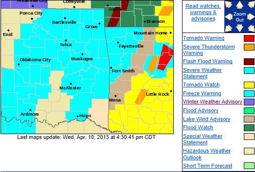
HAZARDOUS WEATHER...
* COLD AIR HAS OVERSPREAD THE AREA. WITH PARTIAL CLEARING
TONIGHT...TEMPERATURES
WILL DROP TO NEAR OR BELOW FREEZING OVER
A LARGE PORTION OF THE AREA. FREEZING TEMPERATURES MAY BE MORE
SCATTERED OVER SOUTHEAST OKLAHOMA AND NORTHWEST ARKANSAS WHERE
THE CLOUDS WILL BE SLOWER
TO CLEAR. HOWEVER...TYPICALLY COLD
LOCATIONS MAY STILL DROP TO NEAR OR BELOW FREEZING. PERSONS WHO
HAVE ALREADY PLANTED TENDER VEGETATION SHOULD CONSIDER
PROTECTING THEIR PLANTINGS.
IMPACTS...
* THESE CONDITIONS WILL KILL PLANTS AND OTHER TENDER VEGETATION
THAT ARE LEFT OUTDOORS OR UNPROTECTED.
DEFINITION...
* A FREEZE WARNING MEANS FREEZING TEMPERATURES WILL OCCUR.
PRECAUTIONARY/PREPAREDNESS
ACTIONS...
* OUTDOOR WATER PIPES SHOULD BE WRAPPED...DRAINED...OR ALLOWED TO
RUN IN A SLOW STEADY
STREAM. PRECAUTIONS SHOULD ALSO BE TAKEN TO
PROTECT SMALL PLANTS AND TENDER VEGETATION.
Tuesday, April 9, 2013
Severe Weather Threat Remains OvernightThunderstorms failed to form along and in front of the cold front but are expected to form behind the cold front that is currently
moving into the Tulsa area.
1-2 inches of rain is expected overnight along with potentially large amounts of small
hail and a chance of large hail and damaging winds.
Storms are expected to become more numerous towards midnight
and last through Wednesday morning. Temps will fall into the 40's by midnight and 30's shortly thereafter
and will struggle to reach 40 on Tuesday. There is a freeze expected Wednesday overnight into Thursday morning.
Updates to follow if needed...
Tue, April 9, 2013 | link
Winter Weather Advisory Issued NW of TulsaWINTER WEATHER ADVISORY IN EFFECT FROM 4 AM TO 1 PM CDT WEDNESDAY... THE NATIONAL WEATHER SERVICE IN TULSA
HAS ISSUED A WINTER WEATHER ADVISORY FOR SLEET AND FREEZING RAIN...WHICH IS IN EFFECT FROM 4 AM TO 1 PM CDT WEDNESDAY... FOR THE FOLLOWING COUNTIES... * IN OKLAHOMA...PAWNEE AND OSAGE. 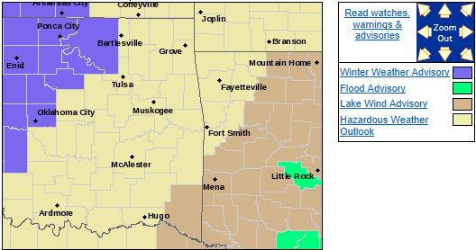 HAZARDOUS WEATHER... * RAIN WILL CHANGE TO FREEZING RAIN AND SLEET LATE TONIGHT AND CONTINUE
WEDNESDAY MORNING. THE FREEZING RAIN MAY ACCUMULATE ON ELEVATED SURFACES SUCH AS TREES AND POWER LINES. * LITTLE SLEET ACCUMULATION AND LESS THAN A QUARTER INCH OF ICE ACCUMULATION IS EXPECTED FROM 4
AM TO 1 PM CDT WEDNESDAY. IMPACTS... * POWER OUTAGES WILL BE POSSIBLE IN THE ADVISORY AREA. SOME SLICK SPOTS MAY DEVELOP ON BRIDGES AND OVERPASSES. DEFINITION... * A WINTER WEATHER ADVISORY MEANS
THAT WINTRY PRECIPITATION MAY ACCUMULATE. PRECAUTIONARY/PREPAREDNESS ACTIONS... * USE EXTRA
CAUTION IF DRIVING...ESPECIALLY ON BRIDGES AND OVERPASSES. * STAY TUNED TO NOAA WEATHER RADIO...COMMERCIAL
RADIO OR TELEVISION FOR THE LATEST INFORMATION CONCERNING THIS WEATHER EVENT. ADDITIONAL
WEATHER INFORMATION CAN ALSO BE FOUND AT: WEATHER.GOV/TULSA.
Severe Risk Slightly Downgraded But Still PresentThere remains a slight risk of severe weather across all of NE Oklahoma. This means that severe weather will likely occur
but the level of severity is not expected to be as high as before.
The primary threat along the front will be isolated
and brief tornados as circulations develop with very little notice. Large hail to the size of tennis balls will
become an increasing threat after the cold front moves through.
If a storm happens to get going well ahead of the cold
front it would likely be tornadic and contain hail to the size of baseballs.
The severe threat is highest for Tulsa
and points west from 7PM-1AM and from Tulsa to the east after 1AM.
A tornado watch will likely be issued west
of Tulsa in the next couple of hours and it will likely be expanded eastward as the evening progresses.
The area
at risk is the same as the previous update with the only difference being that the moderate risk area is now a slight risk
area. 1-2 inches of rain is also expected across most of the area.
An update will be posted when a watch is issued
for NE Oklahoma.
Tue, April 9, 2013 | link
There is a Slight to Moderate Risk of Severe Weather This EveningThe chance for the most severe weather appears to be just west of Tulsa at this point but severe weather is expected
to impact all of NE Oklahoma this evening. Large hail to tennis ball size, damaging winds, and tornado's
are possible with the main tornado threat appearing to be from Tulsa to the west. Scattered storms could
form early this evening to the west of Tulsa. If they do, they would likely become severe very quickly and would have the
capability to form large tornados. As the evening progresses, a line of storms is expected to form along a cold front and
sweep through the area after 9:00. Large hail, damaging winds, heavy rain, and even an embedded tornado is possible in this
line. Here are the SPC and Tulsa NWS severe weather graphics for today. Updates to follow throughout the
day. 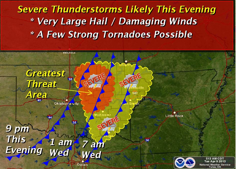 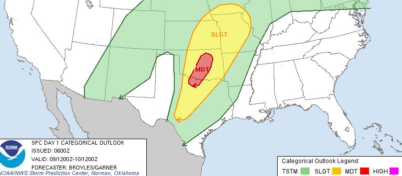
Monday, April 8, 2013
There is a Slight Risk of Severe Weather Tuesday EveningThere is a slight risk of severe weather for all of NE Oklahoma for primarily Tuesday evening after 6:00pm. Large
hail, damaging winds, and even a chance of tornadoes are possible through midnight then large hail, damaging winds, and heavy
rain through noon on Wednesday. Here is the SPC risk map. 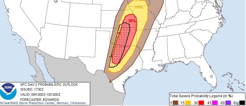
Updates to follow. Most likely Tuesday morning.
|