|
Tuesday, January 29, 2013
Tornado Watch Issued for All of NE OKTHE NATIONAL WEATHER SERVICE HAS ISSUED TORNADO WATCH 6 IN EFFECT UNTIL 3 PM CST THIS AFTERNOON FOR THE FOLLOWING
AREAS 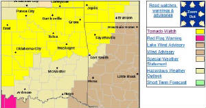 IN OKLAHOMA THIS WATCH INCLUDES 16 COUNTIES IN EAST CENTRAL OKLAHOMA CHEROKEE
MUSKOGEE OKFUSKEE
SEQUOYAH IN NORTHEAST
OKLAHOMA ADAIR
CRAIG DELAWARE
MAYES NOWATA
OKMULGEE OTTAWA
ROGERS TULSA
WAGONER WASHINGTON
THIS INCLUDES THE CITIES OF...BARTLESVILLE...BENTONVILLE... BERRYVILLE...CLAREMORE...EUFAULA...EUREKA SPRINGS... FAYETTEVILLE...HUNTSVILLE...JAY...MIAMI...MUSKOGEE...NOWATA... OKEMAH...OKMULGEE...PRYOR...ROGERS...SALLISAW...SPRINGDALE... STILWELL...TAHLEQUAH...TULSA...VAN BUREN...VINITA AND WAGONER.
Tornado Watch Issued West of TulsaTORNADO WATCH 5 IS IN EFFECT UNTIL 1200 PM CST FOR THE FOLLOWING LOCATIONS 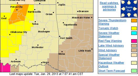 OK . OKLAHOMA COUNTIES INCLUDED ARE ALFALFA
BLAINE CADDO CANADIAN
CLEVELAND COMANCHE COTTON
CREEK CUSTER DEWEY
GARFIELD GARVIN GRADY
GRANT GREER HARMON
JACKSON KAY KINGFISHER
KIOWA LINCOLN LOGAN
MAJOR MCCLAIN NOBLE
OKLAHOMA OSAGE PAWNEE
PAYNE POTTAWATOMIE STEPHENS
TILLMAN WASHITA
Monday, January 28, 2013
Slight Risk of Severe Weather Tonight and Tuesday Across Most of NE OKThere is a slight risk of severe weather this evening across most of NE Oklahoma including a slightly enhanced tornado risk
mainly from Tulsa to the north. Damaging winds, large hail, and isolated tornados are possible after
7:00PM this evening. Here is the Tulsa NWS risk map for this evening: 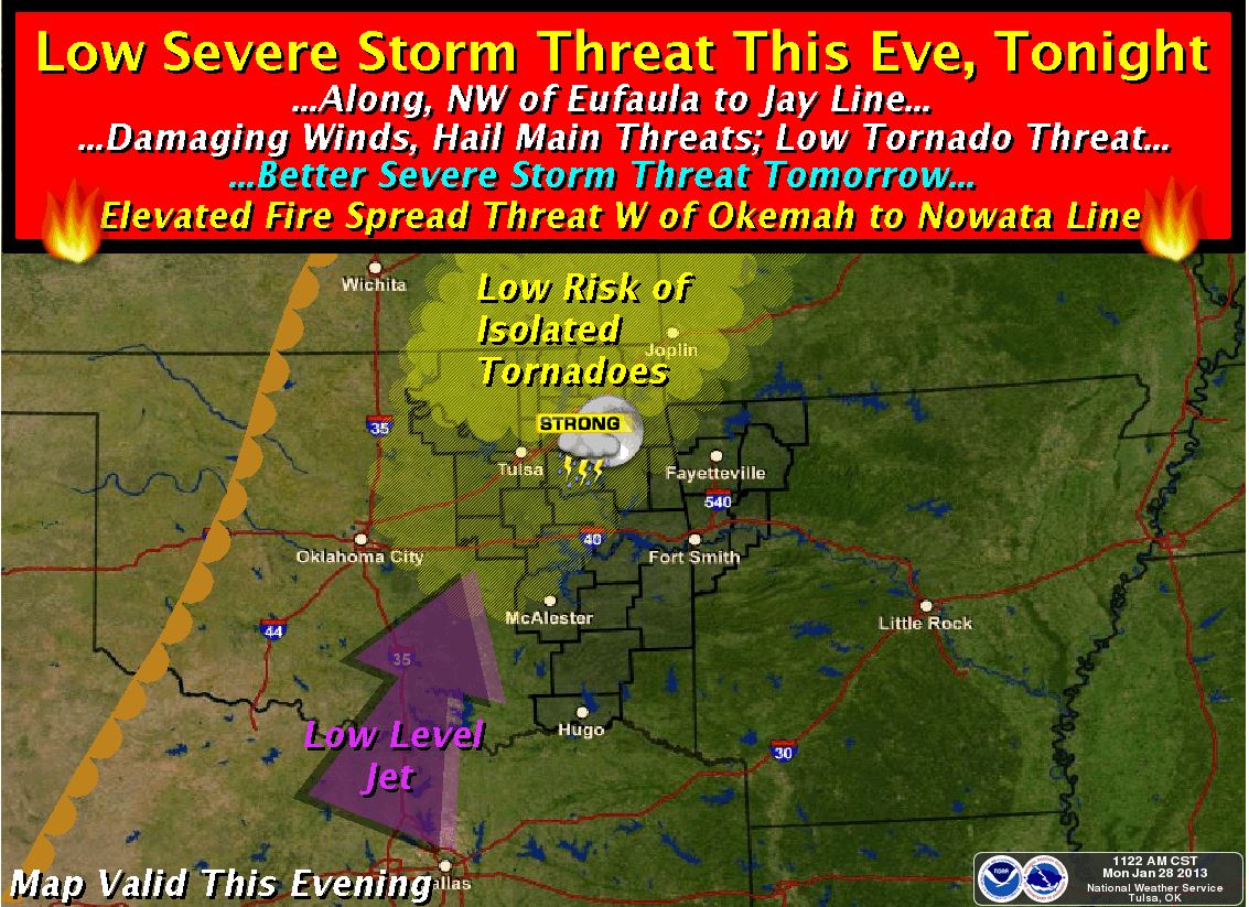 Here is an SPC risk map for today that has a slightly different area highlighted. If storms form in
these areas they will likely track into the areas noted by the Tulsa NWS graphic above.  There is also a slight risk for severe weather on Tuesday from 7:00AM through 4:00PM with the greatest risk
from around 10:00AM through 1:00PM. Damaging winds will be the primary threat Tuesday but large hail can not be ruled out. Here is the SPC risk map for Tuesday: 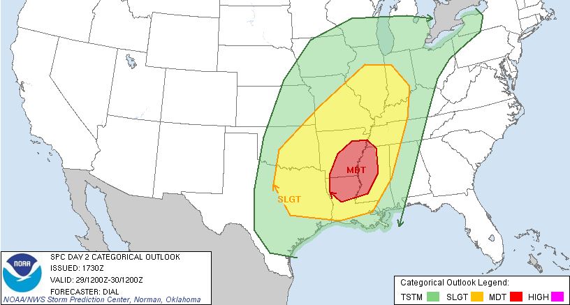 Updates to follow as needed.
Saturday, January 12, 2013
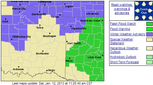
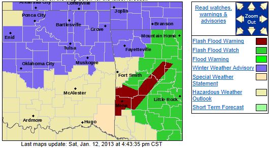
Winter Weather Advisory Issued for Parts of NE OK1035 AM CST SAT JAN 12 2013 ...WINTER WEATHER ADVISORY NOW IN EFFECT UNTIL 4 AM CST SUNDAY...
THE NATIONAL
WEATHER SERVICE IN TULSA HAS ADJUSTED THE TIMING OF
THE WINTER WEATHER ADVISORY AND IT IS NOW IN EFFECT UNTIL 4 AM CST
SUNDAY...
FOR THE FOLLOWING COUNTIES...
* IN OKLAHOMA...CHEROKEE...ADAIR...CREEK...OKFUSKEE...OKMULGEE...
WAGONER...TULSA...ROGERS...MAYES...DELAWARE...WASHINGTON...
OSAGE...CRAIG...NOWATA...PAWNEE...OTTAWA AND MUSKOGEE. IN
ARKANSAS...WASHINGTON...MADISON...BENTON AND CARROLL.

* WINTRY PRECIPITATION IS EXPECTED TO DEVELOP THIS AFTERNOON AND
CONTINUE INTO THE
OVERNIGHT HOURS BEHIND A STRONG COLD FRONT
MOVING THROUGH THE REGION TODAY. RAIN MIXED WITH SLEET WILL
CONTINUE ACROSS NORTHEAST OKLAHOMA BEFORE CHANGING TO SLEET AND
SNOW BY LATE AFTERNOON. RAIN
WILL CONTINUE OVER NORTHWEST
ARKANSAS THIS AFTERNOON...SWITCHING OVER TO FREEZING RAIN THIS
EVENING...THEN FREEZING DRIZZLE OVERNIGHT.
* 1 TO 2 INCHES OF SNOW ACCUMULATION NEAR THE OKLAHOMA
AND KANSAS
BORDER AND LESS THAN A TENTH OF AN INCH OF ICE ACCUMULATION
OVER FAR NORTHWEST
ARKANSAS IS EXPECTED THROUGH TONIGHT.
IMPACTS...
* ROADS IN THE ADVISORY AREA MAY BECOME SLICK
AND HAZARDOUS...
ESPECIALLY ON BRIDGES AND OVERPASSES AND NON-TREATED SURFACES. DEFINITION...
*
A WINTER WEATHER ADVISORY MEANS THAT WINTRY PRECIPITATION MAY
ACCUMULATE ON ROADWAYS. PRECAUTIONARY/PREPAREDNESS
ACTIONS...
* USE EXTRA CAUTION IF DRIVING. ATTEMPT TO STAY ON TREATED
ROADWAYS. EXPECT TRAVEL
DELAYS. * STAY TUNED TO NOAA WEATHER RADIO...COMMERCIAL RADIO OR
TELEVISION FOR THE LATEST INFORMATION
CONCERNING THIS WEATHER
EVENT. ADDITIONAL WEATHER INFORMATION CAN ALSO BE FOUND AT:
WEATHER.GOV/TULSA.
|