|
Friday, December 28, 2012
WINTER WEATHER ADVISORY IN EFFECT UNTIL 6 PM CST THIS EVENING......WINTER WEATHER ADVISORY IN EFFECT UNTIL 6 PM CST THIS EVENING... THE NATIONAL WEATHER SERVICE IN TULSA HAS ISSUED
A WINTER WEATHER ADVISORY FOR SNOW...WHICH IS IN EFFECT UNTIL 6 PM CST THIS EVENING... FOR THE FOLLOWING COUNTIES... * IN OKLAHOMA...CHEROKEE...ADAIR...CREEK...OKFUSKEE...OKMULGEE... WAGONER...TULSA...ROGERS...MAYES...DELAWARE...PAWNEE...OTTAWA... WASHINGTON...OSAGE...CRAIG...NOWATA...PITTSBURG...MCINTOSH AND MUSKOGEE.  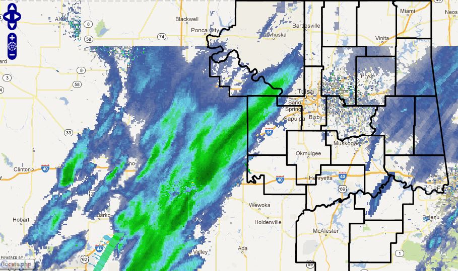 HAZARDOUS WEATHER... * A BAND OF MODERATE SNOW IS MOVING EAST ACROSS CENTRAL OKLAHOMA
AND WILL BE MOVING INTO EAST CENTRAL AND NORTHEAST OKLAHOMA BY THIS AFTERNOON. A QUICK HALF-INCH TO INCH
OF SNOW ACCUMULATION IS EXPECTED...WHICH COULD COLLECT ON ROADWAYS. * A HALF INCH TO AN INCH
OF SNOW ACCUMULATION EXPECTED...WITH THE HEAVIER AMOUNTS MAINLY OVER EAST CENTRAL OKLAHOMA. IMPACTS... * THE SNOW WILL BE HEAVY ENOUGH IN THE BAND TO ACCUMULATE ON SOME ROADS IN THE ADVISORY AREA...DESPITE
ITS SHORT DURATION. WHERE THE SNOW ACCUMULATES ON ROADS YOU CAN EXPECT SLICK AND POTENTIALLY
HAZARDOUS CONDITIONS...ESPECIALLY ON BRIDGES AND OVERPASSES AND NON-TREATED SURFACES. DEFINITION... * A WINTER WEATHER ADVISORY MEANS THAT WINTRY PRECIPITATION MAY ACCUMULATE ON ROADWAYS. PRECAUTIONARY/PREPAREDNESS
ACTIONS... * USE EXTRA CAUTION IF DRIVING. ATTEMPT TO STAY ON TREATED ROADWAYS. EXPECT TRAVEL DELAYS. * STAY TUNED TO NOAA WEATHER RADIO...COMMERCIAL RADIO OR TELEVISION FOR THE LATEST INFORMATION
CONCERNING THIS WEATHER EVENT. ADDITIONAL WEATHER INFORMATION CAN ALSO BE FOUND AT: WEATHER.GOV/TULSA.
Thursday, December 27, 2012
Frezing Rain Advisory Issued for Far Eastern and SE OKFREEZING RAIN ADVISORY IN EFFECT UNTIL 8 AM CST FRIDAY... THE NATIONAL WEATHER SERVICE IN TULSA HAS ISSUED A FREEZING
RAIN ADVISORY...WHICH IS IN EFFECT UNTIL 8 AM CST FRIDAY... FOR THE FOLLOWING COUNTIES... * IN OKLAHOMA...CHOCTAW...CHEROKEE...ADAIR...SEQUOYAH...
PUSHMATAHA...LE FLORE...LATIMER AND HASKELL. IN ARKANSAS... BENTON...SEBASTIAN...WASHINGTON...CARROLL...
MADISON...FRANKLIN AND CRAWFORD. 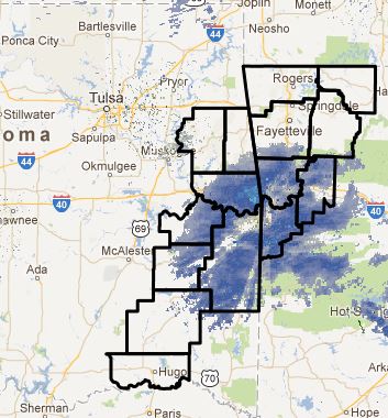  HAZARDOUS WEATHER... * RADAR ECHOS ARE CURRENTLY EXPANDING WITH REPORTS OF FREEZING DRIZZLE
IN SEVERAL LOCATIONS. WITH TEMPERATURES NEAR OR BELOW FREEZING EXPECTED TO CONTINUE... LIGHT ICE ACCUMULATION
MAY OCCUR. * LESS THAN A TENTH OF AN INCH OF ICE ACCUMULATION IS EXPECTED
UNTIL 8 AM CST FRIDAY. IMPACTS... * ROADS IN THE ADVISORY AREA MAY BECOME SLICK AND HAZARDOUS...
ESPECIALLY ON BRIDGES AND OVERPASSES AND NON-TREATED SURFACES. DEFINITION... * A FREEZING RAIN ADVISORY MEANS
THAT PERIODS OF FREEZING RAIN OR FREEZING DRIZZLE MAY ACCUMULATE ON ROADWAYS. PRECAUTIONARY/PREPAREDNESS
ACTIONS... * USE EXTRA CAUTION IF DRIVING. ATTEMPT TO STAY ON TREATED ROADWAYS. EXPECT TRAVEL DELAYS. * STAY TUNED TO NOAA WEATHER RADIO...COMMERCIAL RADIO OR TELEVISION FOR THE LATEST INFORMATION
CONCERNING THIS WEATHER EVENT. ADDITIONAL WEATHER INFORMATION CAN ALSO BE FOUND AT:
WEATHER.GOV/TULSA.
Freezing Drizzle Possible Late Tonight. Be Aware of Potential Slick Roads in the A.M.DEC 27 2012
...PATCHY FREEZING DRIZZLE OR FREEZING LIGHT RAIN POSSIBLE
LATE TONIGHT INTO FRIDAY MORNING...
PATCHY DRIZZLE AND FREEZING DRIZZLE IS EXPECTED TO DEVELOP LATE
TONIGHT INTO FRIDAY MORNING ACROSS EASTERN OKLAHOMA
AND NORTHWEST
ARKANSAS. PATCHY LIGHT FREEZING RAIN MAY ALSO BE POSSIBLE LATE
TONIGHT INTO FRIDAY MORNING ACROSS
PORTIONS OF EAST-CENTRAL OKLAHOMA
INTO NORTHWEST ARKANSAS. THE FREEZING DRIZZLE/LIGHT FREEZING RAIN
MAY PRODUCE
A THIN GLAZE OF ICE ON ELEVATED SURFACES INCLUDING
BRIDGES AND OVERPASSES CREATING HAZARDOUS DRIVING CONDITIONS.
THE
PRECIPITATION IS EXPECTED TO COME TO AN END BY EARLY FRIDAY AFTERNOON.
FREEZING DRIZZLE/LIGHT FREEZING RAIN OFTEN
RESULTS IN A VERY THIN...
ALMOST INVISIBLE GLAZE OF ICE ON ROADWAYS. EVEN JUST A VERY THIN
LAYER OF ICE CAN CAUSE
A VEHICLE TO QUICKLY LOSE TRACTION. MOTORISTS
SHOULD REMAIN ALERT FOR RAPIDLY CHANGING ROAD CONDITIONS...AND ARE
ENCOURAGED
TO REDUCE SPEEDS AND INCREASE THE DISTANCE BETWEEN OTHER
VEHICLES SHOULD HAZARDOUS CONDITIONS OCCUR.
STAY
TUNED TO NOAA WEATHER RADIO...FOR THE LATEST FORECASTS.
ADDITIONAL WEATHER INFORMATION CAN ALSO BE FOUND AT:
WEATHER.GOV/TULSA.
Thu, December 27, 2012 | link
Monday, December 24, 2012
Christmas Day Winter Storm UpdateThe models have shifted the storm well south and areas north of I44 look to only recieve possibly an inch or two of snow.
For Tulsa, light freezing rain and sleet will develop by 6:00AM and should transition to snow by noon. It does
not appear the freezing rain of sleet will add up to much but bridges and overpasses will become slick and hazardous quickly. Further south, significant snow could fall with totals reach 6-10 inches near I40. If the storm tracks
further north, snowfall amounts for Tulsa could increase. If it tracks further and further south as the models show, Tulsa
could end up with very little snow. The Winter Storm Warning for Tulsa has been downgraded to a Winter Weather
Advisory while the Winter Storm Warning has been extended further south. It will be very cold and very windy across
the entire area. Here are the expected snowfall amounts from the Tulsa NWS: 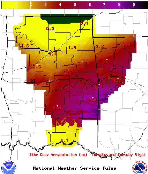 Here are the latest warnings and advisories: 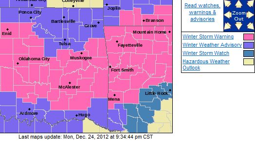
Winter Storm Warning Issued, Including for the Tulsa Metro AreaURGENT - WINTER WEATHER MESSAGE NATIONAL WEATHER SERVICE TULSA OK 626 AM CST MON DEC 24 2012 ...SIGNIFICANT
WINTER STORM TO IMPACT MUCH OF THE AREA CHRISTMAS DAY INTO CHRISTMAS NIGHT... .A POTENT UPPER
LEVEL STORM SYSTEM WILL MOVE INTO THE AREA CHRISTMAS DAY INTO CHRISTMAS NIGHT WITH SIGNIFICANT SNOWFALL OVER PARTS OF EASTERN OKLAHOMA AND NORTHWEST ARKANSAS. HAZARDOUS WEATHER...
* PRECIPITATION
WILL INITIALLY BEGIN AS RAIN...QUICKLY MIXING
WITH SLEET ACROSS PORTIONS OF EASTERN OKLAHOMA CHRISTMAS
MORNING BEFORE
TRANSITIONING TO SNOW BY LATE MORNING. THE MIXED
PRECIPITATION WILL LIKELY TRANSITION TO SNOW BY MID TO LATE
AFTERNOON
ACROSS NORTHWEST ARKANSAS. THE SNOW WILL GRADUALLY
END FROM WEST TO EAST CHRISTMAS NIGHT.
* SNOW...HEAVY AT
TIMES...WITH 4 TO 8 INCHES OF ACCUMULATION IS
LIKELY CHRISTMAS DAY INTO CHRISTMAS NIGHT WITH LOCALLY HIGHER
AMOUNTS
POSSIBLE. WIND CHILLS WILL FALL TO NEAR ZERO BY
WEDNESDAY MORNING ACROSS NORTHEAST OKLAHOMA.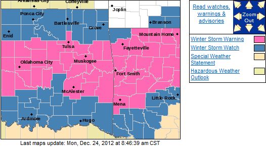 FOR THE FOLLOWING COUNTIES... * IN OKLAHOMA...CHEROKEE...ADAIR...CREEK...OKFUSKEE...OKMULGEE...
WAGONER...TULSA...PITTSBURG...SEQUOYAH...MCINTOSH...MUSKOGEE... LE FLORE...LATIMER AND HASKELL. IN ARKANSAS...WASHINGTON... MADISON...CRAWFORD...SEBASTIAN... CARROLL AND FRANKLIN. Tulsa NWS Snowfall Forecast
(There are indications higher amounts could fall) 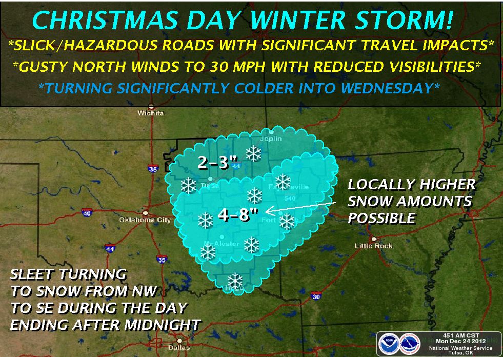 IMPACTS... * ROADS WILL LIKELY BECOME SLICK AND HAZARDOUS MAKING TRAVEL DIFFICULT
OR IMPOSSIBLE DUE TO CLOSED ROADS. POWER OUTAGES MAY OCCUR IN SOME AREAS. GUSTY NORTH WINDS WILL REDUCE
VISIBILITIES WITH BLOWING AND DRIFTING SNOW. PRECAUTIONARY/PREPAREDNESS ACTIONS... * PERSONS
SHOULD PLAN ON TRAVEL DELAYS DUE TO SLICK SNOW PACKED ROADS. SOME ROADS COULD BECOME IMPASSABLE OR CLOSED.
PERSONS SHOULD CONSIDER TRAVELING TODAY OR TONIGHT...IF POSSIBLE...AHEAD OF THE WINTER
STORM. * IF TRAVEL IS ABSOLUTELY NECESSARY...CONSIDER TAKING A WINTER STORM KIT ALONG WITH YOU...INCLUDING
SUCH ITEMS AS TIRE CHAINS ...BOOSTER CABLES...FLASHLIGHT...SHOVEL...BLANKETS AND EXTRA
CLOTHING. ALSO TAKE WATER...A FIRST AID KIT...OR ANYTHING ELSE THAT WOULD HELP YOU SURVIVE IN CASE YOU BECOME
STRANDED. * MAKE SURE YOU HAVE AN ADEQUATE SUPPLY OF FOOD...WATER AND THE NECESSARY MEDICATION
TO LAST THROUGH THE DURATION OF THE WINTER STORM. * STAY TUNED TO NOAA WEATHER RADIO...COMMERCIAL
RADIO OR TELEVISION FOR THE LATEST INFORMATION CONCERNING THIS WEATHER EVENT. ADDITIONAL
WEATHER INFORMATION CAN ALSO BE FOUND AT: WEATHER.GOV/TULSA. && $$
Sunday, December 23, 2012
Winter Storm Watch Issued West and South and Southeast of TulsaHere is the snowfall forecast this Winter Storm Watch is based on. A north or south shift of this storm by 100 miles could
dramatically change the snow for Tulsa. 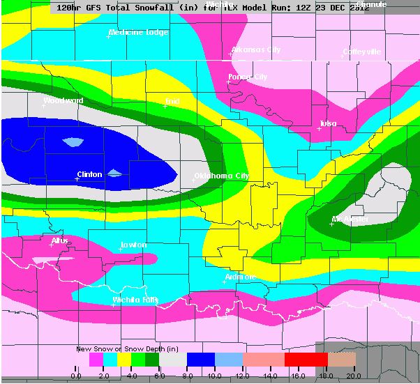 URGENT - WINTER WEATHER MESSAGE NATIONAL WEATHER SERVICE TULSA OK 302 PM CST SUN DEC 23 2012 ...WINTER STORM WATCH IN EFFECT FROM TUESDAY AFTERNOON THROUGH TUESDAY EVENING... THE NATIONAL WEATHER
SERVICE IN TULSA HAS ISSUED A WINTER STORM WATCH FOR SNOW...WHICH IS IN EFFECT FROM TUESDAY AFTERNOON THROUGH TUESDAY
EVENING... FOR THE FOLLOWING COUNTIES... * IN OKLAHOMA...MUSKOGEE...MCINTOSH...CHOCTAW...CHEROKEE...
ADAIR...OKFUSKEE...PITTSBURG...SEQUOYAH...OKMULGEE... PUSHMATAHA...LE FLORE...LATIMER AND HASKELL. IN ARKANSAS... WASHINGTON...SEBASTIAN...CARROLL...MADISON... FRANKLIN AND CRAWFORD. 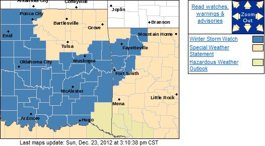 HAZARDOUS WEATHER... * A POWERFUL UPPER LEVEL STORM SYSTEM IS EXPECTED TO MOVE INTO THE
SOUTHERN PLAINS ON CHRISTMAS DAY. A BAND OF HEAVY SNOW IS EXPECTED TO SET UP FROM SOUTHEAST OK ON INTO WEST
CENTRAL AND NORTHWEST ARKANSAS DURING THE AFTERNOON AND CONTINUE INTO THE EVENING HOURS.
THE SNOW WILL TAPER OFF AFTER MIDNIGHT TUESDAY NIGHT. * UP TO 7 INCHES OF SNOW ACCUMULATION IS
POSSIBLE FROM TUESDAY AFTERNOON THROUGH TUESDAY EVENING. IMPACTS... * ROADS...BRIDGES...AND
OVERPASSES MAY BECOME SLICK AND HAZARDOUS IN THE WATCH AREA...MAKING TRAVEL TREACHEROUS. POWER OUTAGES ARE POSSIBLE DEFINITION... * A WINTER STORM WATCH MEANS THE POTENTIAL FOR HEAVY SNOW
ACCUMULATION IN THE WATCH AREA IN THE NEXT 48 HOURS TO 72 HOURS. PRECAUTIONARY/PREPAREDNESS ACTIONS... * CONSIDER
CHANGING TRAVEL PLANS. MAKE SURE YOU HAVE AN ADEQUATE SUPPLY OF FOOD...WATER AND THE NECESSARY MEDICATION
TO LAST THROUGH THE DURATION OF THE WINTER STORM. * STAY TUNED TO NOAA WEATHER RADIO...COMMERCIAL
RADIO OR TELEVISION FOR THE LATEST INFORMATION CONCERNING THIS WEATHER EVENT. ADDITIONAL
WEATHER INFORMATION CAN ALSO BE FOUND AT: WEATHER.GOV/TULSA.
White Christmas PotentialIt is looking like a potential white Christmas for parts of NE Oklahoma. Snow should begin early Christmas morning
and could be heavy at times. There is some difference in the models concerning where the heaviest snow will fall
but currently the it appears 1-4 inches is likely in Tulsa. Parts of the area could get up to 4-8
inches of snow. There could still be adjustments to the snowfall forecast so stay tuned for updates. Here
is the current Tulsa NWS snowfall forecast. 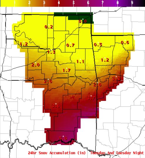 Here is another possible solution with the heaviest snows. 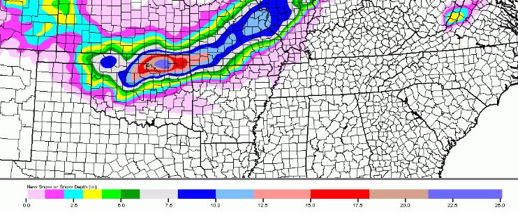
Friday, December 21, 2012
Christmas Holiday Snow UpdateThe models have tamed and it is currently looking like under 2 inches for most of the area through Dec 26. Snow should start
Christmas evening and end early on the 26th. Stay tuned to local media and NWS as the forecasts evolve. Here is the latest Tulsa NWS snowfall forecast. 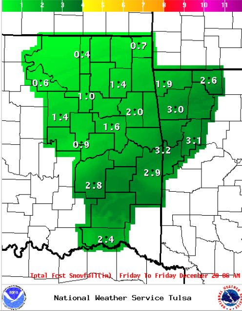
Thursday, December 20, 2012
Winter Weather Potential UpdateThe last couple of model runs have again backed off on the snow for Dec 25-27th. There has been some consistency today
but things are still subject to change so if you have travels plans, stay tuned to the local media and NWS for updates as
I hope things will become much clearer by Sunday night. Right now, because of the inconsistencies, 1-3 inches
for Christmas night and Dec 26 is a good place to be. It is expected to be a cold and wet Christmas day regardless. It is also still shwoing a New Years Eve/New Years Day storm with 6-10 inches possible with it. Here is
the Dec 26 snowfall map according to the GFS model(as seen, it shows no snow): 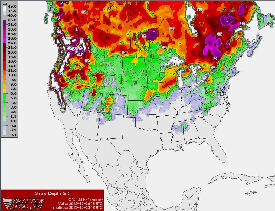 Here is the Jan 1 snowfall map. 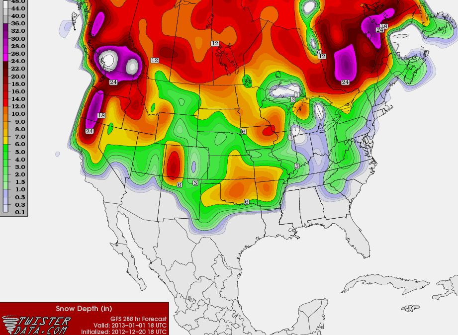
Wednesday, December 19, 2012
Tornado Watch Issued East of TulsaIN OKLAHOMA THIS WATCH INCLUDES 15 COUNTIES IN EAST CENTRAL OKLAHOMA CHEROKEE
MUSKOGEE SEQUOYAH
IN NORTHEAST OKLAHOMA ADAIR
DELAWARE MAYES
OTTAWA WAGONER
IN SOUTHEAST OKLAHOMA CHOCTAW
HASKELL LATIMER
LE FLORE MCINTOSH
PITTSBURG PUSHMATAHA
THIS INCLUDES THE CITIES OF...ANTLERS...BENTONVILLE... BERRYVILLE...CHARLESTON...CLAYTON...EUFAULA...EUREKA
SPRINGS... FAYETTEVILLE...FORT SMITH...HUGO...HUNTSVILLE...JAY...MCALESTER... MIAMI...MUSKOGEE...OZARK...POTEAU...PRYOR...ROGERS...SALLISAW... SPRINGDALE...STIGLER...STILWELL...TAHLEQUAH...VAN BUREN... WAGONER AND WILBURTON. 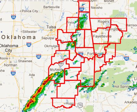
Slight Risk of Severe Weather Across NE Oklahoma This EveningThere is a slight risk of severe across all of eastern Oklahoam this evening after 8:00 this evening. Damaging
winds and tornadoes are the primary threats. The SPC has issued a discussion concerning a possible tornado watch
for this area. 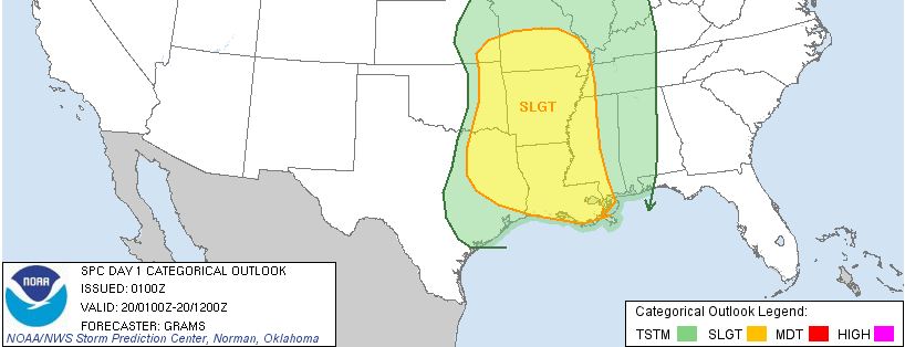
Update on Potential Winter StormsThe GFS model maintained for a run after my post yesterday but then backed off totally for a couple of runs and
is now back saying 1-6 inches in parts of the area Dec 26-27 and another 1-4 on New Years Eve and New Years Day. Again, this is still relatively far out and is subject change so these updates at this point
are strictly to make everyone aware that there could be travel impacts after Christmas.
There is
a chance of a dusting tonight from roughly I44 to the north but whatever falls will be light and due to ground temps, will
not stick around very long. Here is the latest GFS snow accumulation forecast for Dec 26-27. The forecast
for snow will likely change and there is still the possibiltiy there could be none so stayed tuned to the local media and
this blog for updates leading up to Christmas. 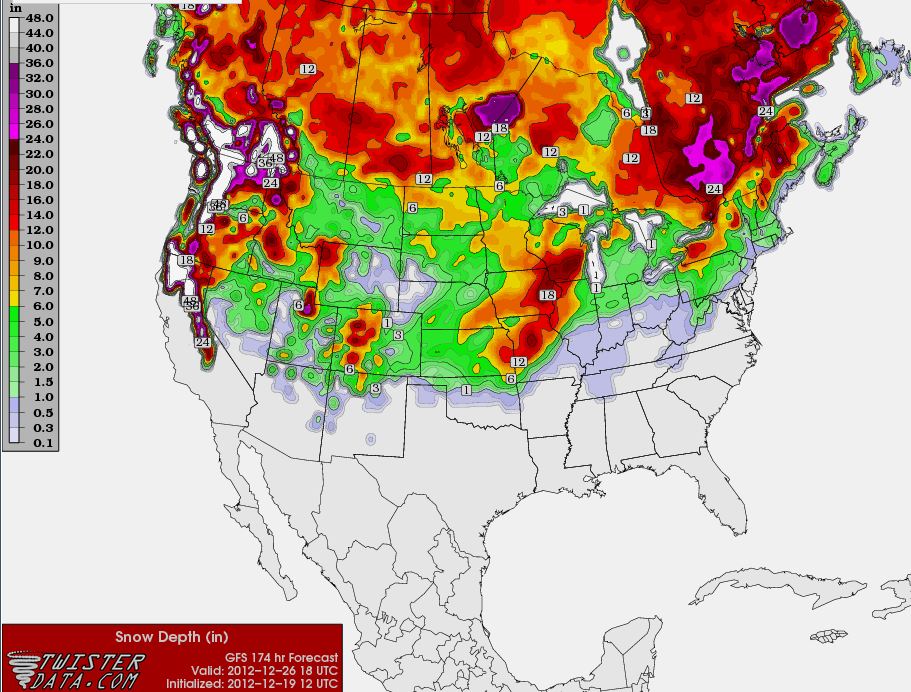
Tuesday, December 18, 2012
Potential Winter Storms Dec 26 and Dec 31The models
continue to become more in agreement with a significant snow storm impacting the area on Dec 26-27 and another on Dec
31-Jan 1.
Please be advised that this forecast event is still several days out and future forecasts will likely
change in regards to locations, amounts, and timing.
This is a preliminary advisory for those who plan to travel
to be aware of the potential storm and to stay tuned to future forecasts.
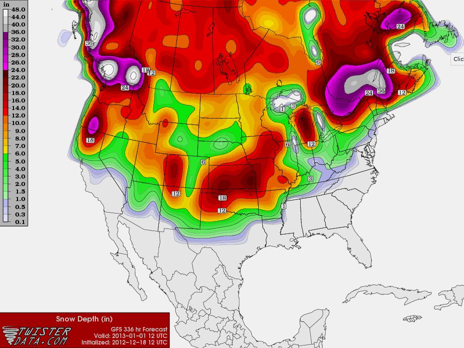
Total snow amounts from both
storms are show below on New Year’s Day with this particular model run being very generous with amounts of 12-18 inches shown
across most of NE OKlahoma.
8-10 inches with the intial storm and 4-6 with the second one.
Saturday, December 15, 2012
Red Flag Fire Warning Issued for Parts of NE OKRED FLAG WARNING IN EFFECT FROM NOON TODAY TO 6 PM CST THIS EVENING... THE NATIONAL WEATHER SERVICE IN TULSA
HAS ISSUED A RED FLAG WARNING...WHICH IS IN EFFECT FROM NOON TODAY TO 6 PM CST THIS EVENING... FOR THE
FOLLOWING COUNTIES... * IN OKLAHOMA...PUSHMATAHA...MUSKOGEE...CREEK...CHOCTAW... PITTSBURG...OKFUSKEE...OKMULGEE...WAGONER...TULSA... MCINTOSH...LATIMER AND HASKELL. 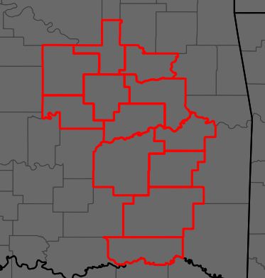 HAZARDOUS WEATHER... * EXTREME FIRE BEHAVIOR IS EXPECTED THIS AFTERNOON ACROSS PARTS OF
EASTERN OKLAHOMA TO THE SOUTH OF HIGHWAY 412 AND WEST OF HIGHWAY 69 AS A RESULT OF GUSTY WINDS...UNSEASONABLY
WARM TEMPERATURES...A DRY AIRMASS...AND ONGOING DROUGHT CONDITIONS. * RELATIVE HUMIDITIES AS
LOW AS 20 PERCENT. * STRONG SOUTHWESTERLY WIND GUSTS AS HIGH AS 30 MPH. IMPACTS... * ANY FIRES
WILL QUICKLY SPREAD OUT OF CONTROL AND ENDANGER LIVES AND PROPERTY. DEFINITION... * A RED
FLAG WARNING MEANS THAT A DANGEROUS COMBINATION OF WEATHER CONDITIONS AND DRY VEGETATION IS EXPECTED WITHIN
24 HOURS...FAVORING RAPID GROWTH AND SPREAD OF ANY WILDFIRES. THE PRIMARY WEATHER FACTORS
INCLUDE STRONGER WINDS...LOWER HUMIDITIES...AND WARMER TEMPERATURES. PRECAUTIONARY/PREPAREDNESS
ACTIONS... * DISPOSE OF CIGARETTES PROPERLY AND AVOID ACTIVITIES THAT COULD START FIRES. *
STAY TUNED TO NOAA WEATHER RADIO...COMMERCIAL RADIO OR TELEVISION FOR THE LATEST INFORMATION CONCERNING
THIS WEATHER EVENT. ADDITIONAL WEATHER INFORMATION CAN ALSO BE FOUND AT: WEATHER.GOV/TULSA.
|