|
Thursday, August 23, 2012
Fire Weather Warning Expanded East Through 9:00PM TonightRED FLAG WARNING REMAINS IN EFFECT UNTIL 9 PM CDT THIS EVENING... A RED FLAG WARNING IS IN EFFECT... FOR THE FOLLOWING COUNTIES... * IN OKLAHOMA...OTTAWA...OSAGE...CRAIG...NOWATA...PAWNEE AND WASHINGTON. 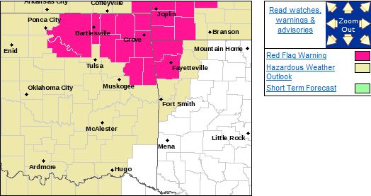 HAZARDOUS WEATHER... * RELATIVE HUMIDITIES VALUES OF 20 TO 25 PERCENT. * SOUTH WIND 15 TO
20 MPH WITH GUSTS 25 TO 30 MPH. * FIRE SPREAD INDEX VALUES OF 50 TO 60. IMPACTS... * ANY FIRES
WILL QUICKLY SPREAD OUT OF CONTROL AND ENDANGER LIVES AND PROPERTY. PRECAUTIONARY/PREPAREDNESS
ACTIONS... * DISPOSE OF CIGARETTES PROPERLY AND AVOID ACTIVITIES THAT COULD START FIRES. *
STAY TUNED TO NOAA WEATHER RADIO...COMMERCIAL RADIO OR TELEVISION FOR THE LATEST INFORMATION CONCERNING
THIS WEATHER EVENT. ADDITIONAL WEATHER INFORMATION CAN ALSO BE FOUND AT: WEATHER.GOV/TULSA.
Wednesday, August 22, 2012
CRITICAL FIRE DANGER NORTH OF HIGHWAY 412 IN NORTHEAST OKLAHOMARED FLAG WARNING IN EFFECT UNTIL 9 PM CDT THIS EVENING... THE NATIONAL WEATHER SERVICE IN TULSA HAS ISSUED A RED
FLAG WARNING...WHICH IS IN EFFECT UNTIL 9 PM CDT THIS EVENING... FOR THE FOLLOWING COUNTIES... * IN
OKLAHOMA...WASHINGTON...OSAGE...CRAIG...NOWATA...PAWNEE... OTTAWA...ROGERS AND MAYES. 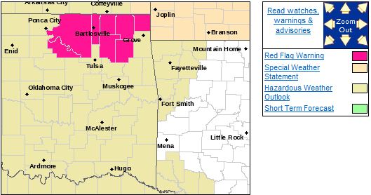 HAZARDOUS WEATHER... * RELATIVE HUMIDITY VALUES OF 20 TO 25 PERCENT ACROSS NORTHEAST OKLAHOMA. * SOUTH WINDS OF 10 TO 20 MILES AN HOUR WITH HIGHER GUST. * SPREAD INDEX VALUES OF 50 TO 60. IMPACTS... * FIRES WILL SPREAD QUICKLY AND MAKE SUPPRESSION EFFORTS DIFFICULT AT BEST. FIRES MAY ENDANGER LIVES AND
PROPERTY. DEFINITION... * A RED FLAG WARNING MEANS THAT A DANGEROUS COMBINATION OF WEATHER
CONDITIONS AND DRY VEGETATION IS EXPECTED... FAVORING RAPID GROWTH AND SPREAD OF ANY WILDFIRES.
THE PRIMARY WEATHER FACTORS INCLUDE WIND AND LOW HUMIDITY. PRECAUTIONARY/PREPAREDNESS ACTIONS... * DISPOSE
OF CIGARETTES PROPERLY AND AVOID ACTIVITIES THAT COULD START FIRES. * STAY TUNED TO NOAA WEATHER
RADIO...COMMERCIAL RADIO OR TELEVISION FOR THE LATEST INFORMATION CONCERNING THIS WEATHER
EVENT. ADDITIONAL WEATHER INFORMATION CAN ALSO BE FOUND AT: WEATHER.GOV/TULSA.
Thursday, August 16, 2012
There is a Slight Chance of Severe Weather Across all of NE Oklahoma TodayThere is a chance of severe weather today mainly after 11:00AM across all of NE Oklahoma, especially east of highway
169. Damaging downburst winds and hail to the size of golfballs are the primary threats. Here is the SPC risk map
for today: 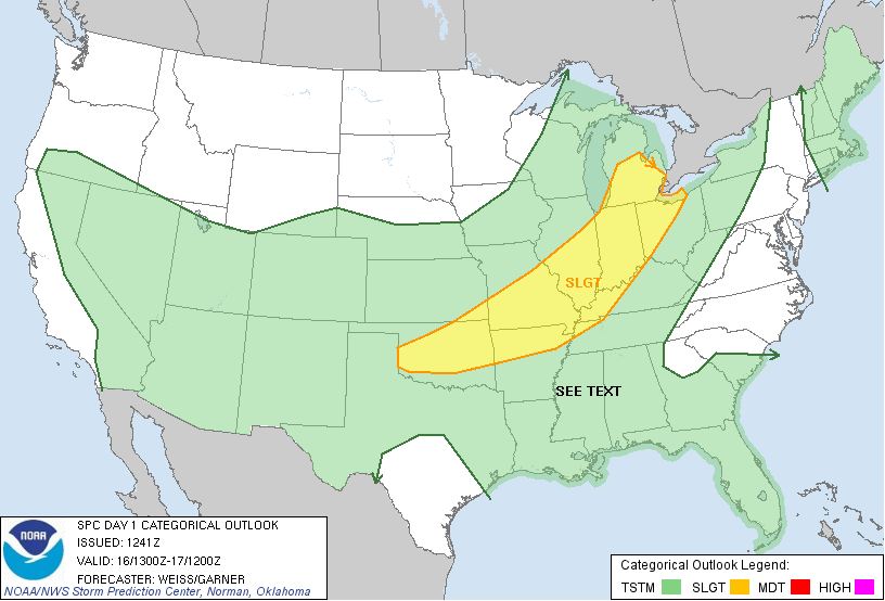
Tuesday, August 14, 2012
Public health warning issued for West Nile virusThis isn't technically weather related but certainly an issue of outdoor safety and something I know from experience
you don't want to mess around with.
Public Health Officials Urge Oklahomans to “fight the bite” The Oklahoma State Department of Health warned all Oklahomans today to
do what they can to avoid mosquito bites or face increased risk of West Nile virus. At least one death has now been reported
and 24 new cases of WNV have been confirmed in Oklahoma in the past week.
“Prevention is the key to protection,” said State Health Commissioner
Dr. Terry Cline. “One bite from an infected mosquito can lead to a severe and possibly life-altering illness. We urge
everyone to use insect repellent when outdoors and to mosquito-proof their home as best possible.”
Healthy, active adults who are 50 and older have the
highest risk of illness caused by WNV. That’s certainly true in Oklahoma, where most cases have occurred in persons
over 40 and have been neuroinvasive WNV disease, the most severe form of WNV infection that causes inflammation of the brain
and spinal cord.
While
persons who work outdoors in occupations like farming or construction are at risk of getting bitten by an infected mosquito,
most Oklahomans with WNV disease believe they were exposed to mosquitoes and WNV while doing activities around their residence,
like working in their yards, tending flower beds or relaxing on the patio.
Thus far this year, 55 cases of WNV disease have been confirmed in Oklahomans
from 14 counties. The counties with the
highest numbers of cases include Tulsa (14), Oklahoma (12), Carter (9), Pittsburg
(7), Muskogee (3), and Garfield (2). The age range of cases is 12 to 90 years. Since WNV activity in Oklahoma often does not
peak until September or early October, more cases are expected.
Illness associated with WNV ranges from no symptoms at all to milder “West Nile
Fever” symptoms to serious neurologic disease. Symptoms of West Nile Fever include sudden onset of fever, headache,
nausea, dizziness, and muscle weakness. Sometimes swollen lymph glands or a skin rash are also present with West Nile Fever.
Symptoms of serious neurologic WNV disease can progress quickly and may include high fever, headache, stiff neck, mental confusion
or disorientation, numbness, convulsions, and coma. A polio-type paralysis of an arm or leg may also be caused by WNV. Some
of the neurological effects of WNV may be permanent or fatal. Persons should seek medical attention if any of these symptoms
develop, especially within two weeks after mosquito bites. Oklahomans are urged to “fight the bite” and take the following precautions to protect themselves
against mosquito bites: - Use
an insect repellent containing DEET on exposed skin and clothing when you go outdoors. (Insect repellent with permethrin should
be used on clothing only.)
- Place mosquito repellent in
a handy and visible location in the home for easy access.
- Repair
or install window and door screens to keep mosquitoes out of your home.
- Prevent items such as buckets, cans, flower pots, and tires from holding standing water so mosquitoes don’t
have a place to breed.
- Empty, clean and refill your bird
baths and pet’s outdoor water bowl daily.
- Clean
leaves and debris from rain gutters regularly to ensure they are not clogged.
For more information on WNV, including prevention, visit http://ads.health.ok.gov and click on “Disease Information” then “West Nile Virus.”
Saturday, August 4, 2012
Slight Risk of Severe Weather Along the Kansas BorderThere is a slight risk of severeweather along the Kansas border this evening after 6:00. Elsewhere in NE, there is a
slight chance of thunderstorms this evening mainly north of I-44. Here is ths SPC risk map for today: 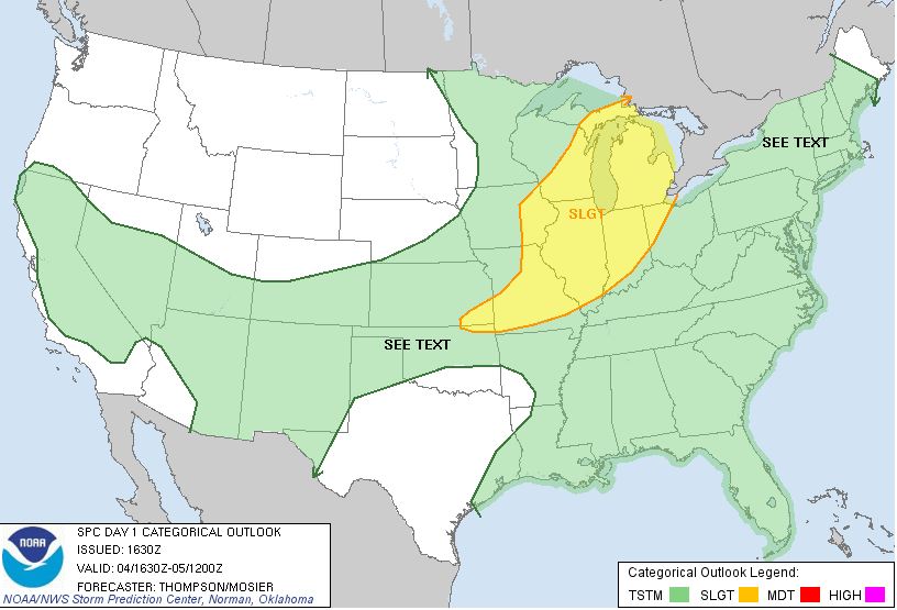
Critical Fire Weather in NE Oklahoma Today!RED FLAG WARNING IN EFFECT FROM 10 AM THIS MORNING TO 7 PM CDT
THIS EVENING...
THE NATIONAL WEATHER SERVICE
IN TULSA HAS ISSUED A RED FLAG
WARNING...WHICH IS IN EFFECT FROM 10 AM THIS MORNING TO 7 PM CDT
THIS EVENING...
FOR THE FOLLOWING COUNTIES...
* IN OKLAHOMA...CHEROKEE AND DELAWARE.
HAZARDOUS WEATHER...
* CRITICAL
FIRE WEATHER CONDITIONS WILL DEVELOP ACROSS MUCH OF
NORTHEAST OKLAHOMA BY MID MORNING AND CONTINUE THROUGH
THE
AFTERNOON HOURS.
* LOW RELATIVE HUMIDITIES OF 15 TO 25 PERCENT.
* SOUTH TO SOUTHWEST
WINDS 10 TO 20 MPH WITH GUSTS TO NEAR 30
MPH.
IMPACTS...
* ANY FIRES WILL QUICKLY SPREAD
OUT OF CONTROL AND ENDANGER
LIVES AND PROPERTY.
DEFINITION...
* A RED FLAG WARNING MEANS
THAT A DANGEROUS COMBINATION OF
WEATHER CONDITIONS AND DRY VEGETATION IS EXPECTED WITHIN 24
HOURS...FAVORING RAPID GROWTH AND SPREAD OF ANY WILDFIRES.
THE PRIMARY WEATHER FACTORS INCLUDE STRONGER
WINDS...LOWER
HUMIDITIES...AND WARMER TEMPERATURES.
Sat, August 4, 2012 | link
Friday, August 3, 2012
Fire Weather Watch Issued for Parts of NE OKTHE NATIONAL WEATHER SERVICE IN TULSA HAS ISSUED A FIRE WEATHER WATCH...WHICH IS IN EFFECT FROM SATURDAY MORNING THROUGH
SATURDAY EVENING... FOR THE FOLLOWING COUNTIES... * IN OKLAHOMA...WAGONER...OTTAWA...ROGERS...PAWNEE...
WASHINGTON...OSAGE...CRAIG...NOWATA...CREEK...OKFUSKEE... MCINTOSH...MUSKOGEE...TULSA...OKMULGEE
AND MAYES. 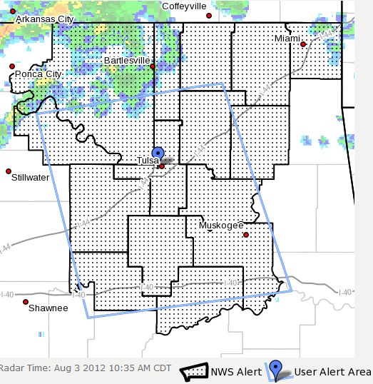 HAZARDOUS WEATHER... * SOUTHWEST WINDS 15 TO 20 MPH ARE EXPECTED WITH GUSTS 25 TO 30 MPH
ACROSS NORTHEAST OKLAHOMA FROM MID MORNING THROUGH AT LEAST MID AFTERNOON. WINDS SHOULD BACK OFF LATE IN
THE AFTERNOON AND INTO THE EVENING AS THE FRONTAL BOUNDARY REACHES OR PUSHES JUST SOUTH
OF THE KANSAS BORDER. THE WINDS...VERY DRY AIR...AND VERY HOT TEMPERATURES WILL POTENTIALLY YIELD CRITICAL
FIRE WEATHER CONDITIONS DURING THE DAY SATURDAY. * RELATIVE HUMIDITIES AS LOW AS 13.0 PERCENT * STRONG WIND GUSTS 25 TO 30 MPH IMPACTS... * THE PURPOSE OF FIRE WEATHER WATCHES AND RED FLAG WARNINGS
ARE TO ALERT LAND MANAGEMENT AGENCIES OF DEVELOPING WEATHER CONDITIONS THAT...WHEN COMBINED
WITH CRITICALLY DRY WILDLAND FUELS...COULD LEAD TO DANGEROUS WILDFIRES. TIMELY AND ACCURATE
WATCHES AND WARNINGS ENABLE FIRE FIGHTING AGENCIES TO MANAGE RESOURCES AND PREPARE APPROPRIATE SUPPRESSION
RESPONSES FOR PROTECTING LIFE AND PROPERTY. DEFINITION... * A FIRE WEATHER WATCH MEANS
THAT CRITICAL FIRE WEATHER CONDITIONS ARE FORECAST TO OCCUR. PRECAUTIONARY/PREPAREDNESS ACTIONS... * LISTEN FOR LATER FORECASTS AND POSSIBLE RED FLAG WARNINGS. * STAY TUNED TO NOAA WEATHER RADIO...COMMERCIAL
RADIO OR TELEVISION FOR THE LATEST INFORMATION CONCERNING THIS WEATHER EVENT. ADDITIONAL
WEATHER INFORMATION CAN ALSO BE FOUND AT: WEATHER.GOV/TULSA.
Excessive Heat Warning Extended Through Saturday EveningHopefully you were one of the few that got a little rain last night and this morning and hopefully we have another shot at
some rain this evening and on Sunday! Regardless, be careful out there! It's HOT HOT HOT! THE NATIONAL
WEATHER SERVICE IN TULSA HAS ADJUSTED THE TIMING OF THE EXCESSIVE HEAT WARNING AND IT IS NOW IN EFFECT UNTIL 7 PM CDT
SATURDAY... FOR THE FOLLOWING COUNTIES... * IN OKLAHOMA...CHEROKEE...ADAIR...CREEK...OKFUSKEE...OKMULGEE... WAGONER...TULSA...ROGERS...MAYES...DELAWARE...PAWNEE...OTTAWA... WASHINGTON...OSAGE...CRAIG...NOWATA...PITTSBURG...SEQUOYAH... MCINTOSH...MUSKOGEE AND HASKELL. IN ARKANSAS...WASHINGTON...CRAWFORD...BENTON AND
SEBASTIAN. 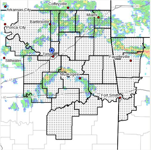 HAZARDOUS WEATHER... * DANGEROUS AFTERNOON HEAT INDICES IN THE 105 TO 115 DEGREE RANGE
ARE EXPECTED TODAY AND SATURDAY AHEAD OF AN APPROACHING COLD FRONT. OVERNIGHT LOWS WILL REMAIN VERY WARM
AND WILL PROVIDE LITTLE IF ANY RELIEF FROM THE HEAT. IMPACTS... * THE COMBINATION OF HOT
TEMPERATURES AND HIGH HUMIDITY WILL COMBINE TO CREATE A DANGEROUS SITUATION IN WHICH HEAT ILLNESSES ARE POSSIBLE. PRECAUTIONARY/PREPAREDNESS ACTIONS... * TAKE EXTRA PRECAUTIONS IF YOU WORK OR
SPEND TIME OUTSIDE. WHEN POSSIBLE...RESCHEDULE STRENUOUS ACTIVITIES TO EARLY MORNING OR
EVENING. KNOW THE SIGNS AND SYMPTOMS OF HEAT EXHAUSTION AND HEAT STROKE. WEAR LIGHT WEIGHT AND LOOSE FITTING
CLOTHING WHEN POSSIBLE AND DRINK PLENTY OF WATER. * TO REDUCE RISK DURING
OUTDOOR WORK THE OCCUPATIONAL SAFETY AND HEALTH ADMINISTRATION RECOMMENDS SCHEDULING FREQUENT REST BREAKS
IN SHADED OR AIR CONDITIONED ENVIRONMENTS. ANYONE OVERCOME BY HEAT SHOULD BE MOVED TO
A COOL AND SHADED LOCATION. HEAT STROKE IS AN EMERGENCY...CALL 911. * STAY TUNED TO NOAA WEATHER
RADIO...COMMERCIAL RADIO OR TELEVISION FOR THE LATEST INFORMATION CONCERNING THIS WEATHER EVENT.
ADDITIONAL WEATHER INFORMATION CAN ALSO BE FOUND AT: WEATHER.GOV/TULSA.
|