|
Tuesday, February 28, 2012
Tornado Watch IssuedWATCH COUNTY NOTIFICATION FOR WATCH 41 NATIONAL WEATHER SERVICE TULSA OK 811 PM CST TUE FEB 28 2012 THE NATIONAL WEATHER SERVICE HAS ISSUED TORNADO WATCH 41 IN EFFECT UNTIL 1 AM CST WEDNESDAY FOR THE FOLLOWING AREAS IN OKLAHOMA THIS WATCH INCLUDES 14 COUNTIES IN EAST CENTRAL OKLAHOMA MUSKOGEE
OKFUSKEE IN NORTHEAST OKLAHOMA CRAIG CREEK
MAYES NOWATA
OKMULGEE OSAGE
PAWNEE ROGERS
TULSA WAGONER
WASHINGTON IN SOUTHEAST OKLAHOMA MCINTOSH
THIS INCLUDES THE CITIES OF...BARTLESVILLE...BRISTOW... CLAREMORE...EUFAULA...MUSKOGEE...NOWATA...OKEMAH...OKMULGEE... PAWHUSKA...PAWNEE...PRYOR...TULSA...VINITA AND WAGONER. 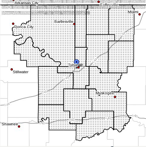
Severe Weather Still Possible This EveningThere remains a threat of severe weather across all of NE Oklahoma this evening with the threat increasing the further
east you go. Hail to the size of golfballs, damaging wind gusts, and isolated tornadoes are all possible. Here is the SPC Tornado threat graphic for this evening: 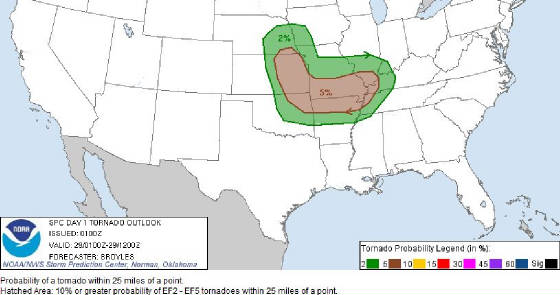 Here is the SPC severe hail threat graphic for this evening. 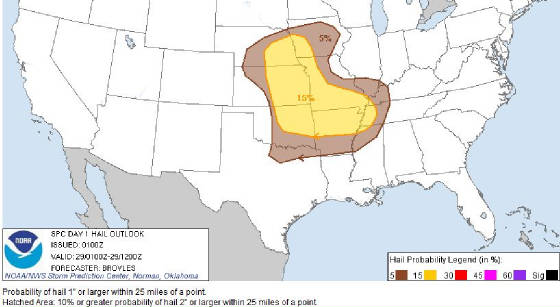
Chance of Severe Weather This EveningThere is a chance of severe weather across most of NE Oklahoma and especially SE Oklahoma this evening. Severe
storms with large hail, damaging winds, and potentially an isolated tornado could be in the Tulsa area by 6:00PM.
The greatest threat for severe weather is south and east of Tulsa where the ingredients are coming together a little better.
Here is the Storm Prediction Center risk area map for today and this evening: 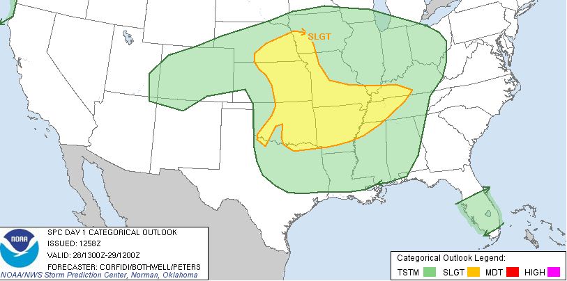 Here is the Tulsa NWS tornado probability risk map for this evening: 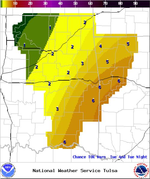 Updates to follow...
Monday, February 20, 2012
Severe Thunderstorm Watch Issued for All of NE Oklahoma A Severe Thunderstorm Watch has been issued for all of NE Oklahoma 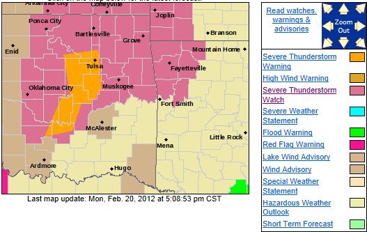 IN OKLAHOMA THE NEW WATCH INCLUDES 8 COUNTIES IN EAST CENTRAL OKLAHOMA MUSKOGEE
IN NORTHEAST OKLAHOMA NOWATA
OKMULGEE ROGERS
TULSA WAGONER
WASHINGTON IN SOUTHEAST OKLAHOMA MCINTOSH
THIS INCLUDES THE CITIES OF...BARTLESVILLE...CLAREMORE... EUFAULA...MUSKOGEE...NOWATA...OKMULGEE...TULSA
AND WAGONER.
Mon, February 20, 2012 | link
Wind Advisory Issued: Gusts to 50MPH Outside of Thunderstorms Possible303 PM CST MON FEB 20 2012 ...WIND ADVISORY NOW IN EFFECT UNTIL 9 PM CST THIS EVENING... THE NATIONAL
WEATHER SERVICE IN TULSA HAS ADJUSTED THE TIMING OF THE WIND ADVISORY AND IT IS NOW IN EFFECT UNTIL 9 PM CST THIS EVENING... FOR THE FOLLOWING COUNTIES... * IN OKLAHOMA...WASHINGTON...WAGONER...OTTAWA...ROGERS...PAWNEE... CREEK...DELAWARE...CHEROKEE...ADAIR...CRAIG...NOWATA... PITTSBURG...OKFUSKEE...MCINTOSH...MUSKOGEE...TULSA...OKMULGEE... MAYES AND OSAGE. IN ARKANSAS...BENTON AND WASHINGTON. 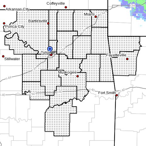 HAZARDOUS WEATHER... * STRONG SOUTHERLY WINDS CONTINUE TO BE OBSERVED THIS AFTERNOON AHEAD
OF A COLD FRONT APPROACHING FROM THE WEST. STRONG AND GUSTY WINDS ARE EXPECTED TO CONTINUE INTO THE EVENING
HOURS BEHIND THE FRONTAL PASSAGE. IMPACTS... * WIND GUST VALUES TO 40 TO 50 MILES AND HOUR
CAN BE EXPECTED. * WINDS THIS STRONG CAN MAKE DRIVING DIFFICULT...ESPECIALLY FOR HIGH PROFILE
VEHICLES. PRECAUTIONARY/PREPAREDNESS ACTIONS... * MOTORISTS SHOULD EXERCISE CAUTION WHILE DRIVING. BE ALERT
TO SUDDEN GUSTS OF WIND WHICH MAY CAUSE YOU TO LOSE CONTROL OF YOUR VEHICLE. EXTRA ATTENTION
SHOULD BE GIVEN TO CROSS WINDS AND ON BRIDGES AND OVERPASSES.
Severe Thunderstorm Watch Issued for Areas West of TulsaA Severe Thunderstorm Watch has been issued for areas west of Tulsa until 10:00PM this evening. Hail to 2 inches in diameter
and wind gusts to 60MPH are possible in the watch area. OKLAHOMA COUNTIES INCLUDED ARE CANADIAN
CLEVELAND CREEK GARFIELD
GARVIN GRADY GRANT
HUGHES KAY KINGFISHER
LINCOLN LOGAN MCCLAIN
NOBLE OKFUSKEE OKLAHOMA
OSAGE PAWNEE PAYNE
PONTOTOC POTTAWATOMIE SEMINOLE 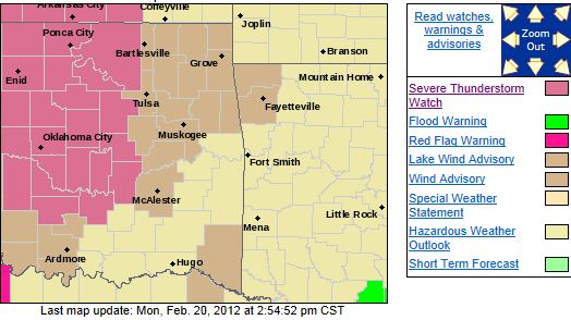
There is a Slight Risk of Severe Weather This EveningThere is a slight chance severe weather across most of NE Oklahoma this evening, mainly during a 7PM - 11PM timeframe. Hail to 2 inches in diameter and wind gusts to 55MPH are possible along with an outside chance of an isolated tornado. Here is the SPC's risk map for this evening: 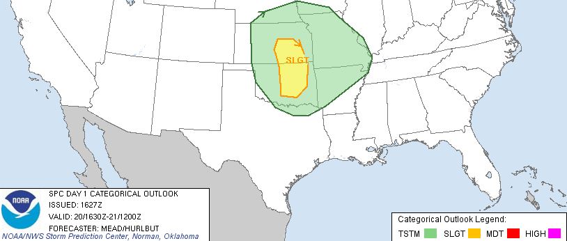
VERY HIGH FIRE DANGER.THE NATIONAL WEATHER SERVICE IN TULSA HAS ISSUED A FIRE WEATHER ALERT WHICH IS IN EFFECT UNTIL 800 PM CST FOR THE
FOLLOWING COUNTIES... IN ARKANSAS... BENTON...CARROLL...WASHINGTON...MADISON...CRAWFORD...FRANKLIN AND SEBASTIAN. IN OKLAHOMA... PUSHMATAHA...CHOCTAW...OSAGE...WASHINGTON...NOWATA...CRAIG... OTTAWA...PAWNEE...TULSA...ROGERS...MAYES...DELAWARE...CREEK...OKFUSKEE... OKMULGEE...WAGONER...CHEROKEE...ADAIR...MUSKOGEE...MCINTOSH...SEQUOYAH... PITTSBURG...HASKELL...LATIMER AND LE FLORE. 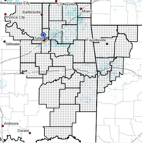 SOUTHERLY WINDS WILL INCREASE AND BECOME GUSTY THIS MORNING THROUGH THIS AFTERNOON. WIND
GUSTS OF 40 TO 50 MILES AN HOUR WILL
BE COMMON IN NORTHEAST OKLAHOMA...WITH GUSTS OF 30 TO 40 MILES AN HOUR ACROSS SOUTHEAST OKLAHOMA AND NORTHWEST ARKANSAS. ALTHOUGH AFTERNOON HUMIDITY VALUES WILL REMAIN ABOVE 40 PERCENT
IN MOST PLACES...THE STRONG WINDS WILL LEAD TO THE POTENTIAL FOR RAPID FIRE SPREAD TODAY. A FIRE WEATHER
ALERT IS ISSUED WHEN DANGEROUS FIRE WEATHER CONDITIONS ARE EXPECTED BUT ARE BELOW RED FLAG CRITERIA. A FIRE WEATHER ALERT MAY ALSO BE ISSUED TO RELAY STATE OR COUNTY FIRE INFORMATION...SUCH AS BURNING BANS.
Sunday, February 12, 2012
Winter Weather Advisory IssuedWINTER WEATHER ADVISORY IS IN EFFECT FROM 10 PM THIS EVENING TO 6 PM CST MONDAY... A WINTER WEATHER ADVISORY
IS IN EFFECT... FOR THE FOLLOWING COUNTIES... * IN OKLAHOMA...CHEROKEE...ADAIR...CREEK...OKFUSKEE...OKMULGEE... WAGONER...TULSA...ROGERS...MAYES...DELAWARE...PAWNEE...OTTAWA... WASHINGTON...OSAGE...CRAIG...NOWATA...SEQUOYAH...MCINTOSH... MUSKOGEE...LE FLORE AND HASKELL. IN ARKANSAS...WASHINGTON... MADISON...CRAWFORD...BENTON...
SEBASTIAN...CARROLL AND FRANKLIN. 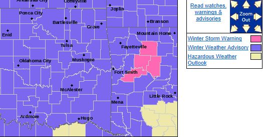 HAZARDOUS WEATHER... * AREAS OF LIGHT TO MODERATE SNOW WILL SPREAD INTO EASTERN OKLAHOMA
AROUND MIDNIGHT TONIGHT...MOVING INTO NORTHWEST ARKANSAS BY SUNRISE MONDAY. THE SNOW WILL BEGIN TO TRANSITION TO MORE OF A SLEET...FREEZING RAIN MIXTURE SOUTH OF A TULSA... FORT SMITH LINE BY MID DAY
MONDAY AND ACROSS THE REMAINDER OF THE AREA MONDAY AFTERNOON. LINGERING AREAS OF DRIZZLE AND
FREEZING DRIZZLE WILL CONTINUE ACROSS NORTHEAST OKLAHOMA AND NORTHWEST ARKANSAS INTO MONDAY EVENING. * SNOW AND SLEET ACCUMULATIONS OF 1 TO 3 INCHES ARE EXPECTED WITH AROUND A TENTH OF AN INCH OF ICE
ACCUMULATION. LOCALLY HIGHER AMOUNTS OF SNOW AND SLEET COULD OCCUR IN THE HIGHER TERRAIN
AREAS OF NORTHWEST ARKANSAS. IMPACTS... * ROADS IN THE ADVISORY AREA MAY BECOME SLICK AND HAZARDOUS... ESPECIALLY ON BRIDGES...OVERPASSES AND NON-TREATED SURFACES. A LIGHT GLAZING OF ICE DUE TO
FREEZING RAIN AND FREEZING DRIZZLE WILL ALSO BE POSSIBLE ON ELEVATED SURFACES. PRECAUTIONARY/PREPAREDNESS
ACTIONS... * USE EXTRA CAUTION IF DRIVING LATE TONIGHT INTO MONDAY MORNING. ATTEMPT TO STAY ON TREATED
ROADWAYS. EXPECT TRAVEL DELAYS. * STAY TUNED TO NOAA WEATHER RADIO...COMMERCIAL RADIO OR TELEVISION
FOR THE LATEST INFORMATION CONCERNING THIS WEATHER EVENT. ADDITIONAL WEATHER INFORMATION CAN ALSO BE FOUND
AT: WEATHER.GOV/TULSA.
Saturday, February 11, 2012
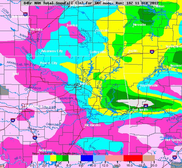
Winter Weather Still Expected but More so Overnight Sunday into MondaySnow is expected to begin falling late Sunday evening after 8:00pm. Snow should gradually increase into the overnight hours
with anywhere from 1-4 inches currently expected across most of NE Oklahoma. Right now, 2-3 inches looks most likely in Tulsa
but there are still some questions about when the precipitation will beging to transition to sleet and freezing rain.
It is possible that more sleet and freezing rain will fall which will limit overall snow accumulations. Any freezing rain
that falls is expected to remain light enough to prevent any power outages or tree damage.
It is expected
that freezing drizzle will occur Monday morning and there is expected to be some travel issues for the morning commute.
Here is the best snowfall forecast I've seen in terms of distribution of snow but this is likely to change over
the next 24 hours.
Friday, February 10, 2012
Winter Weather Expected Sunday into MondayIt appears the impact will be light but could be in the Tulsa area by 6:00pm Sunday and run through late Monday morning.
1-2 inches of snow may fall in the Tulsa area before it begins to transition to sleet, then freezing rain, then rain.
Freezing rain amounts should remain under 2/10th of inch in the Tulsa area.
There will likely be some travel
problems on Monday morning but temps should warm above freezing by late morning and any frozen precipation on roads or highways
should melt.
Here is a NWS Special Weather Statement:
SPECIAL WEATHER STATEMENT
NATIONAL WEATHER SERVICE TULSA OK
1055 AM CST FRI FEB 10 2012
...WINTRY PRECIPITATION LOOKING LIKELY
FOR SUNDAY NIGHT INTO
MONDAY...
A MIX OF WINTRY PRECIPITATION IS EXPECTED ACROSS EASTERN OKLAHOMA
AND
NORTHWEST ARKANSAS FROM LATE SUNDAY NIGHT...CONTINUING INTO
THE DAY MONDAY. THE TIMING OF PRECIPITATION COULD MEAN IMPACTS
FOR
THE MONDAY MORNING COMMUTE.
AN ARCTIC COLD FRONT WILL MOVE SOUTHWARD TODAY AND TONIGHT...USHERING
THE
COLDEST AIR OF THE SEASON INTO THE AREA. WINDY CONDITIONS
FOLLOWING THE COLD FRONTAL PASSAGE COULD CAUSE SUBZERO WIND
CHILLS
SATURDAY MORNING. THE COLD AIR WILL PERSIST ACROSS THE REGION
THROUGH THE WEEKEND.
A FAST MOVING
STORM SYSTEM WILL MOVE OUT OF THE WESTERN UNITED
STATES LATE IN THE WEEKEND...RESULTING IN PRECIPITATION
DEVELOPMENT
ACROSS THE PLAINS REGION. WITH COLD AIR ALREADY IN
PLACE...THE PRECIPITATION WILL LIKELY BEGIN AS SNOW OR SLEET ACROSS
MOST OF NORTHEAST OKLAHOMA AND NORTHWEST ARKANSAS LATE SUNDAY
NIGHT AND EARLY MONDAY MORNING...WITH RAIN OR FREEZING
RAIN ACROSS
SOUTHEAST OKLAHOMA.
AS THE STORM SYSTEM MOVES CLOSER TO AND OVER THE AREA...LOW AND
MID LEVEL
TEMPERATURES WILL INCREASE FROM SOUTH TO NORTH...WHICH
WILL CAUSE THE SNOW AND SLEET TO TRANSITION TO RAIN OR FREEZING
RAIN BY MONDAY MORNING. ENOUGH MID LEVEL DRY AIR MAY MOVE INTO
THE REGION BY MONDAY AFTERNOON TO RESULT IN A TRANSITION
TO
DRIZZLE OR FREEZING DRIZZLE BEFORE PRECIPITATION ENDS MONDAY
NIGHT.
THE HIGHEST SNOW ACCUMULATIONS
WILL LIKELY OCCUR NEAR THE KANSAS
AND MISSOURI BORDERS...AS WELL AS IN THE HIGHER TERRAIN AREAS OF
NORTHWEST ARKANSAS.
AT THIS TIME...IT APPEARS THAT 1 TO 3 INCHES
OF SNOW ACCUMULATION WILL BE POSSIBLE...HOWEVER...THESE FORECAST
AMOUNTS
ARE NOT FINAL. THESE AMOUNTS WILL BE REFINED AS NEW DATA
ARE ANALYZED OVER THE WEEKEND.
THERE IS ALSO THE
POTENTIAL FOR SOME MINOR ICE ACCUMULATIONS TO
THE SOUTH OF THE SNOW ACCUMULATIONS. PROLONGED POWER OUTAGES OR
SIMILAR
MAJOR ICE IMPACTS ARE NOT EXPECTED...ALTHOUGH MINOR ICE
RELATED IMPACTS MAY OCCUR AS WINDS INCREASE BEHIND THE SYSTEM.
DETAILS OF THIS EVENT CONTINUE TO BE REFINED...SO INTERESTED
PARTIES SHOULD MONITOR FORECASTS AND FUTURE STATEMENTS
OVER THE
WEEKEND.
Fri, February 10, 2012 | link
Friday, February 3, 2012
There is a Slight Risk of Severe Weather This EveningThere is a slight risk of severe weather over most of eastern Oklahoma this evening. Showers and thunderstorms are expected
this morning but most likely will not be severe. However, storms are expected to form late this afternoon along
a dryline in western Oklahoma and track east towards NE Oklahoma. The greatest threat for severe weather will be south of
I-40 but there is a risk in NE Oklahoma. Large hail and damaging winds are the primary threats. Here is the Storm
Prediction Centers risk map for today. 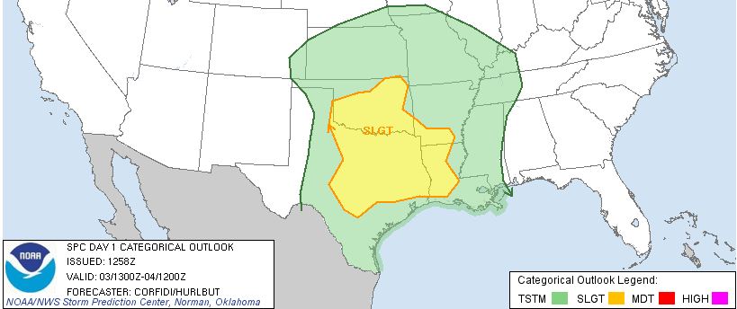 Updates to follow as needed.
|