|
Friday, August 12, 2011
Severe Thunderstorm Watch Extended Until 3:00AMTHE NATIONAL WEATHER SERVICE HAS ISSUED SEVERE THUNDERSTORM WATCH 774 UNTIL 3 AM CDT SATURDAY WHICH REPLACES A PORTION
OF SEVERE THUNDERSTORM WATCH 773. THE NEW WATCH IS VALID FOR THE FOLLOWING AREAS IN OKLAHOMA THE NEW
WATCH INCLUDES 15 COUNTIES 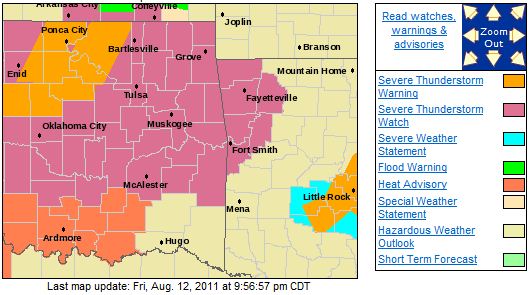 IN EAST CENTRAL OKLAHOMA MUSKOGEE
OKFUSKEE IN NORTHEAST OKLAHOMA CREEK NOWATA
OKMULGEE OSAGE
PAWNEE ROGERS
TULSA WAGONER
WASHINGTON IN SOUTHEAST OKLAHOMA HASKELL
LATIMER MCINTOSH
PITTSBURG THIS INCLUDES THE CITIES
OF...BARTLESVILLE...BRISTOW... CLAREMORE...EUFAULA...MCALESTER...MUSKOGEE...NOWATA...OKEMAH... OKMULGEE...PAWHUSKA...PAWNEE...STIGLER...TULSA... WAGONER AND WILBURTON. A line of severe storms is approaching the Tulsa area. 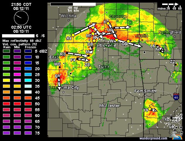
Storms N and E of Tulsa. Severe Thunderstorm Watch ExpandedPower outages possible with these storms and the outflow heading into Tulsa. 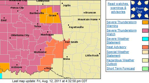
Severe Thunderstorm Watch IssuedA severe thunderstorm watch has been issued for parts of NE and Central Oklahoma until 10:00pm tonight. Heavy rain, damaging
winds, hail to the size of golfballs, and even an isolated tornado are possible. The storms may affect the Tulsa
area as early as 5:30 PM. NATIONAL WEATHER SERVICE TULSA OK 316 PM CDT FRI AUG 12 2011 THE NATIONAL WEATHER SERVICE HAS ISSUED SEVERE THUNDERSTORM WATCH 773 IN EFFECT UNTIL 10 PM CDT THIS EVENING
FOR THE FOLLOWING AREAS 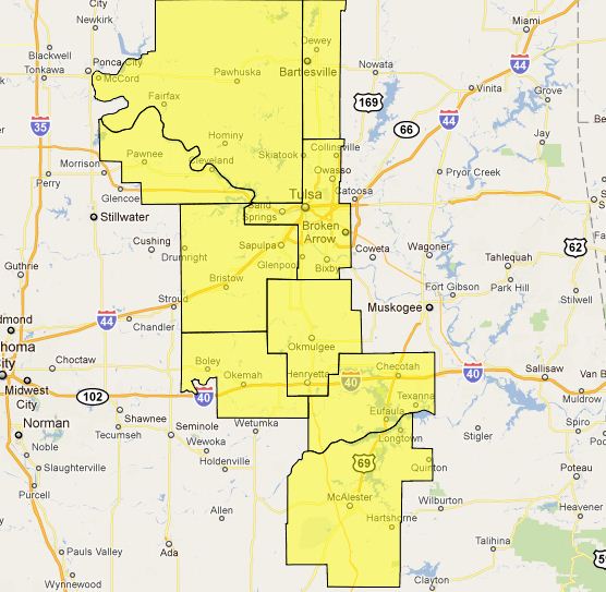 IN OKLAHOMA THIS WATCH INCLUDES 9 COUNTIES IN EAST CENTRAL OKLAHOMA OKFUSKEE
IN NORTHEAST OKLAHOMA CREEK
OKMULGEE OSAGE
PAWNEE TULSA
WASHINGTON IN SOUTHEAST OKLAHOMA MCINTOSH
PITTSBURG THIS INCLUDES THE CITIES OF...BARTLESVILLE...BRISTOW...EUFAULA... MCALESTER...OKEMAH...OKMULGEE...PAWHUSKA...PAWNEE AND TULSA.
Monday, August 8, 2011
Enhanced Fire Danger and Severe Weather Threat Today and TonightExtremely dangerous fire conditions are expected to develop today. High winds, high temps, and low humidity will create an
enhanced wild fire threat today as a cold front approaches. The winds will shift from the SW to the N and NE first as
an outflow boundary crosses the area late this morning then be reinforced as a cold front crosses the area tonight. 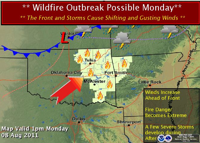 There is a chance of severe storms forming along the front as well with damaging winds being the primary threat. Here is the SPC risk map for today. 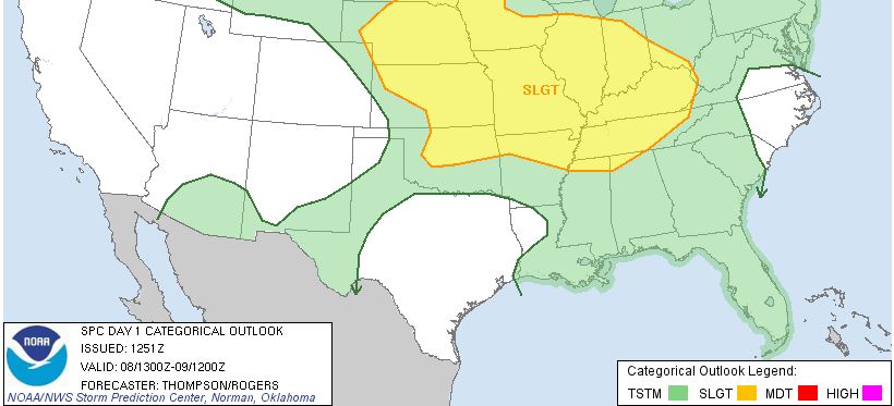
Sunday, August 7, 2011
Intense Heat, Extreme Fire Danger, and a Threat of Severe Weather on MondayExtremely dangerous fire conditions are expected to develop on Monday. High winds, high temps, and low humidity will create
an enhanced wild fire threat on Monday as a cold front approaches. The winds will shift from the SW to the N and NE as a cold
front crosses the area. There is a chance of severe storms forming along the front as well with damaging winds being the primary
threat. More on the storms in the morning, right now the fire danger is the headline. 
Friday, August 5, 2011
...VERY HIGH FIRE DANGER DEVELOPING THIS AFTERNOON...130 AM CDT FRI AUG 5 2011 ...VERY HIGH FIRE DANGER DEVELOPING THIS AFTERNOON... THE NATIONAL WEATHER
SERVICE IN TULSA HAS ISSUED A FIRE WEATHER ALERT WHICH IS IN EFFECT UNTIL 900 PM CDT FOR THE FOLLOWING COUNTIES... IN ARKANSAS... BENTON...CARROLL...WASHINGTON...MADISON...CRAWFORD...FRANKLIN AND SEBASTIAN. IN
OKLAHOMA... PUSHMATAHA...CHOCTAW...OSAGE...WASHINGTON...NOWATA...CRAIG... OTTAWA...PAWNEE...TULSA...ROGERS...MAYES...DELAWARE...CREEK... OKFUSKEE...OKMULGEE...WAGONER...CHEROKEE...ADAIR...MUSKOGEE... MCINTOSH...SEQUOYAH...PITTSBURG...HASKELL...LATIMER
AND LE FLORE. 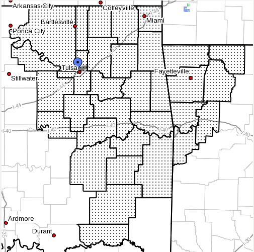 DANGEROUS FIRE WEATHER CONDITIONS HAVE DEVELOPED THIS AFTERNOON AS TEMPERATURES SOAR WELL INTO THE
TRIPLE DIGITS. AFTERNOON HUMIDITIES IN THE 15 TO 25 PERCENT RANGE WILL FUEL AGGRESSIVE FIRE BEHAVIOR WITH ANY
WILDFIRES. SOUTHERLY WINDS OF 10 TO 15 MPH WITH GUSTS TO 25 MPH MPH WILL BE POSSIBLE WITH CONDITIONS APPROACHING RED
FLAG WARNING CRITERIA IN A FEW AREAS. A FIRE WEATHER ALERT IS ISSUED WHEN DANGEROUS FIRE WEATHER CONDITIONS ARE EXPECTED BUT ARE BELOW RED FLAG CRITERIA. A FIRE WEATHER ALERT MAY ALSO BE ISSUED TO RELAY STATE OR COUNTY FIRE
INFORMATION...SUCH AS BURNING BANS. On a lighter or, cooler note, it looks like we may receive a break
in the heat starting next Wednesday with highs dropping down to the low to mid 90's!!!! Rain chances increase during that
period as well. Until then, expect more heat on top of the hot ;o)
Thursday, August 4, 2011
There is a Slight Risk of Severe Weather and a High Risk of Intense Heat TodayThere is a slight risk of severe storms across NE Oklahoma with damaging downburst and winds and marginally severe hail
possible late this afternoon. Here is the SPC risk map for today: 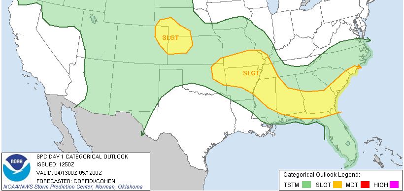 Excessive Heat Warnings remain in effect for the whole area as well as an Ozone Alert for the Tulsa area.
Record heat is expected to continue through the weekend and on Wednesday, near record Ozone levels were reached at 150 which
is nearing VERY unhealthy levels (151) that affect everyone. The record is 159. To minimize the heat risk hydrate
several hours before any outdoor activity, during the activity, and after the activity and take frequent breaks. For the ozone, hold off on mowing your yard, limit your driving, and if you have to get out, combine your trips and lower
your speed as much as possible.
Monday, August 1, 2011
Very Intense Heat Expected This Week
The on-going heat wave looks to kick it up a notch this week with highs above 109 forecast through Thursday
with highs possibly reaching or exceeding the all time record of 115 Tuesday and Wednesday.
Low temperature are
expected to be near record high levels most of the week with temps only expected to cool into the lower 80's on Tuesday,
Wednesday, and Thursday.
This level of heat, especially after the last two months of intense heat, is likely to
cause heat related health issues, even for those who are healthy and feel they are acclimated to it.
Since April,
there have been 66 days with temps above 90. 61 of those occuring since June 1st.
There have been 28 days with temps
above 100 since June 1 and 10 days with temps at or above 105.
Stay safe everyone...
An Excessive Heat Warning is in effect for all of Oklahoma except for the panhandle.
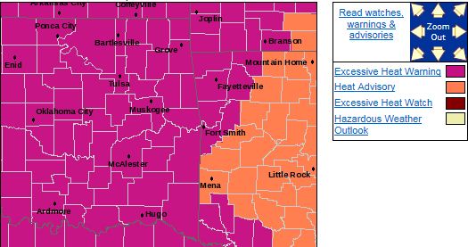
HAZARDOUS WEATHER...
* AFTERNOON HEAT INDICES ARE EXPECTED TO BE IN THE 105 TO 115
RANGE
THIS AFTERNOON. OVERNIGHT LOWS WILL BE VERY WARM AND WILL
THUS PROVIDE LITTLE TO NO RELIEF FROM THE HEAT. THE HEAT IS
THEN EXPECTED TO INTENSIFY TOWARD MIDWEEK...WITH AFTERNOON HIGH
TEMPERATURES CLIMBING INTO THE 110 TO 115 TUESDAY AND
WEDNESDAY
OVER A GOOD PORTION OF EASTERN OKLAHOMA AND WEST CENTRAL
ARKANSAS.
IMPACTS...
* THE COMBINATION
OF HOT TEMPERATURES AND HIGH HUMIDITY WILL
COMBINE TO CREATE A DANGEROUS SITUATION IN WHICH HEAT ILLNESSES
ARE POSSIBLE.
THE HEAT WILL REACH LEVELS NOT SEEN IN THIS AREA
IN QUITE SOME TIME. ANYONE OUTDOORS IN THIS EXTREME HEAT MUST
TAKE
THE PROPER PRECAUTIONS.
PRECAUTIONARY/PREPAREDNESS ACTIONS...
* TAKE EXTRA PRECAUTIONS IF YOU WORK OR SPEND
TIME OUTSIDE. WHEN
POSSIBLE...RESCHEDULE STRENUOUS ACTIVITIES TO EARLY MORNING OR
EVENING. KNOW THE SIGNS AND SYMPTOMS
OF HEAT EXHAUSTION AND HEAT
STROKE. WEAR LIGHT WEIGHT AND LOOSE FITTING CLOTHING WHEN
POSSIBLE AND DRINK PLENTY
OF WATER.
* TO REDUCE RISK DURING
OUTDOOR WORK THE OCCUPATIONAL SAFETY AND HEALTH ADMINISTRATION
RECOMMENDS
SCHEDULING FREQUENT REST BREAKS IN SHADED OR AIR
CONDITIONED ENVIRONMENTS. ANYONE OVERCOME BY HEAT SHOULD BE
MOVED
TO A COOL AND SHADED LOCATION. HEAT STROKE IS AN
EMERGENCY...CALL 911.
* STAY TUNED TO NOAA WEATHER RADIO...COMMERCIAL
RADIO OR TELEVISION
FOR THE LATEST INFORMATION CONCERNING THIS WEATHER EVENT.
ADDITIONAL WEATHER INFORMATION CAN
ALSO BE FOUND AT:
WEATHER.GOV/TULSA.
|