|
Monday, June 20, 2011
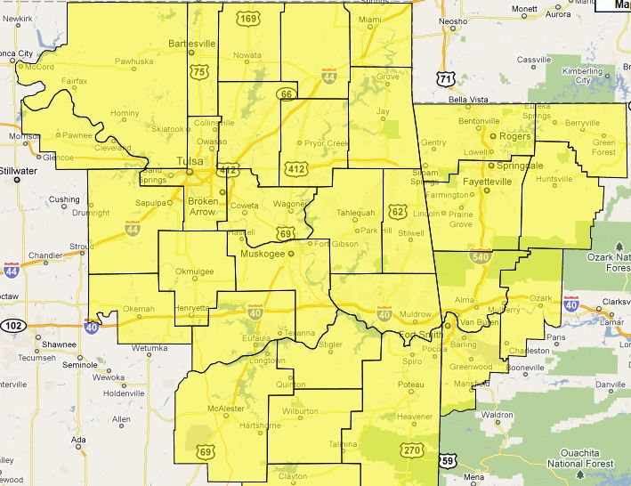
Severe Thunderstorm Watch ExtendedA severe thunderstorm watch has been issued for all of Eastern Oklahoma until 5:00AM.
Damaging winds are the primary
threat along with damaging hail, and frequent lightning.
Here is the watch area:
Severe Storms Still Expected The storms formed later than expected and are moving east a little slower. Storms are lining up west of Tulsa and
will continue to move east. Large hail, damaging winds, and isolated tornadoes remain possible. The current severe thunderstorm
watch will likely be extended to cover all of eastern Oklahoma. Storms are expect to be in Tulsa around 10:00 or
11:00. Here is a look at current radar: 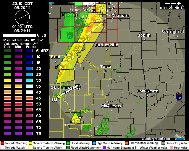
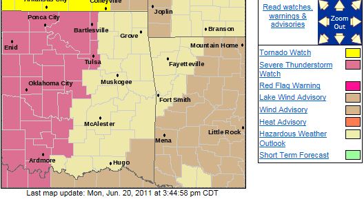
**A Particularly Dangerous Situation Severe Thunderstorm Watch Has Been Issued**A Particularly Dangerous Situation Severe Thunderstorm Watch is in effect until
11:00PM. Damaging winds to 80+ MPH with hail to tennis ball size is very possible. There is a tornado threat, mainly
west of Tulsa, but the biggest threat is damaging winds and large hail. Here is the current NWS watch box.
With the combination of large hail and the expected very strong winds, the threat for damage is amplified.
Golfball size hail being driven by 60MPH winds can cause significant damage.
Severe
thunderstorm warnings issued tonight will possibly be for extremely severe storms. Stay away from windows and doors, and if
in your car, try to seek shelter inside a sturdy structure if the area you're in is warned. Being by windows or in your
car with large hail and strong winds is very dangerous.
The storms could be in the Tulsa area as early as
6:00 but most likely after 7:00.
Significant Severe Weather Expected TonightDamaging winds to 80+ MPH with hail to tennis ball size is very possible. There is a tornado threat, mainly west of
Tulsa, but the biggest threat is damaging winds and large hail.
A lot of the updates recently have indicated the
threats for high winds and large hail but in those instances they haven't been expected to occur together. Tonight is
different as they are expected to occur together in some areas.
With the combination of large hail and
the expected very strong winds, the threat for damage is amplified. Golfball size hail being driven by 60MPH winds can cause
significant damage.
Severe thunderstorm warnings issued tonight will possibly be for extremely severe storms.
Stay away from windows and doors, and if in your car, try to seek shelter inside a sturdy structure if the area your in is
warned. Being by windows or in your car with large hail and strong winds is very dangerous.
The storms could
be in the Tulsa area as early as 6:00 but most likely after 7:00.
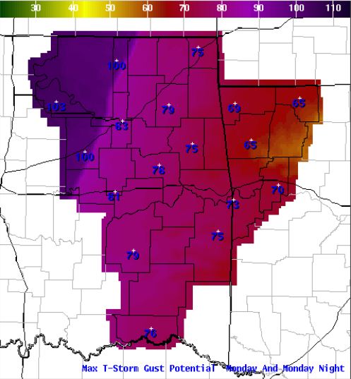
Here is the Tulsa NWS max wind gust graphic
that indicates the potential for 100+ MPH winds west of Tulsa and 80+ MPH winds in Tulsa.
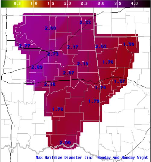
Here is the NWS max hail size graphic indicating up to 2 3/4 inches possible in Tulsa.
Wind Advisory in Effect Until 1:00 PM.URGENT - WEATHER MESSAGE
NATIONAL WEATHER SERVICE TULSA OK
836 AM CDT MON JUN 20 2011
...WIND
ADVISORY IN EFFECT UNTIL 1 PM CDT THIS AFTERNOON...
THE NATIONAL WEATHER SERVICE IN TULSA HAS ISSUED A
WIND ADVISORY...
WHICH IS IN EFFECT UNTIL 1 PM CDT THIS AFTERNOON...
FOR THE FOLLOWING COUNTIES...
* IN OKLAHOMA...PAWNEE...WASHINGTON...OSAGE...CRAIG...NOWATA...
CREEK...OTTAWA...WAGONER...TULSA...ROGERS...MAYES
AND DELAWARE.
HAZARDOUS WEATHER...
* STRONG AND GUSTY SOUTH WINDS WILL CONTINUE THROUGH THE
REMAINDER OF THE MORNING HOURS ACROSS NORTHEAST OKLAHOMA.
IMPACTS...
* WIND GUSTS OF 40 TO
45 MPH WILL BE POSSIBLE.
* WINDS THIS STRONG CAN MAKE DRIVING DIFFICULT...ESPECIALLY FOR
HIGH
PROFILE VEHICLES.
DEFINITION...
* A WIND ADVISORY MEANS THAT WIND GUSTS OF 40 MPH ARE EXPECTED.
PRECAUTIONARY/PREPAREDNESS
ACTIONS...
* MOTORISTS SHOULD EXERCISE CAUTION WHILE DRIVING. BE ALERT TO
SUDDEN GUSTS OF WIND WHICH
MAY CAUSE YOU TO LOSE CONTROL OF YOUR
VEHICLE. EXTRA ATTENTION SHOULD BE GIVEN TO CROSS WINDS AND ON
BRIDGES AND OVERPASSES.
* STAY TUNED TO NOAA WEATHER RADIO...COMMERCIAL RADIO OR TELEVISION
FOR THE LATEST INFORMATION CONCERNING THIS WEATHER EVENT.
ADDITIONAL WEATHER INFORMATION
CAN ALSO BE FOUND AT:
WEATHER.GOV/TULSA.
Mon, June 20, 2011 | link
Severe Weather Expected This Evening and Through the Overnight HoursDamaging winds to 80MPH, hail to the size of tennis balls, and tornadoes are possible, especially in the early evening and
west of highway 75. While the tornado threat decreases later and east of highway 75, all types of severe weather are possible
as the line of storms traverses eastern Oklahoma. Storms may be entering the Tulsa area as early as 6:00PM this
evening. The Tulsa area is currently under a slight risk of severe weather but parts of the area may be upgraded
to a moderate risk by the SPC later today. Here is the latest SPC risk map: 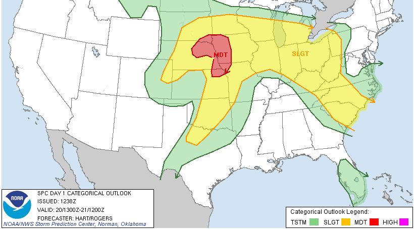 Here is one models representation of radar for 6:00PM this evening: 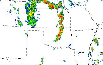
Saturday, June 18, 2011
Severe Threat Likely to Remain North of Tulsa TonightStorms still possible north of I-244 but chance in Tulsa remain small.
I got surprised a few nights ago so I am hesitant
to say the chances in Tulsa are zero.
Updates forthcoming as needed.
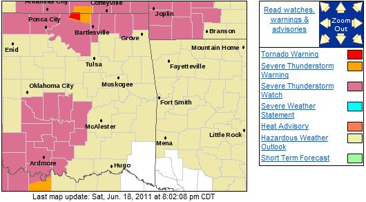
Severe Thunderstorm Watches Issued North and West of TulsaAnother watch may issued later for the Tulsa area.
Current Watches and Warnings from the Tulsa NWS:
Current Radar:
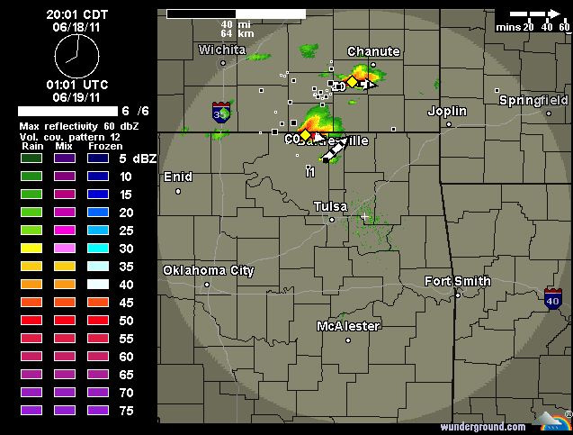
Risk of Severe Weather This Evening and TonightThere is a risk for severe weather this evening and tonight with damaging winds, hail to the size of tennis balls, and
possibly an isolated tornado. Here is the Tulsa NWS risk graphic for this evening: 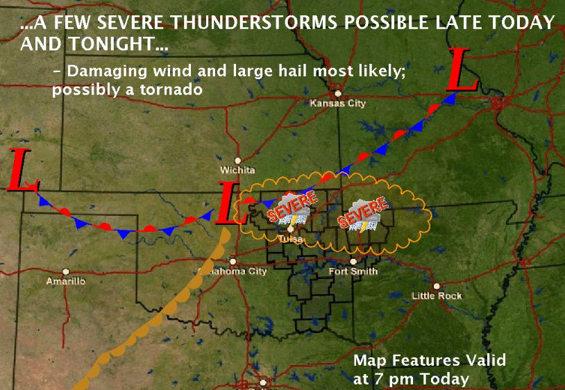
Thursday, June 16, 2011
A Severe Thunderstorm Watch Has Been IssuedA severe thunderstorm watch has been issued for most of NE Oklahoma. A line of severe storms NW of Tulsa are expected to track
through the area this afternoon. Damaging winds are the primary threat although large hail is possible. Below is
the watch area in yellow: 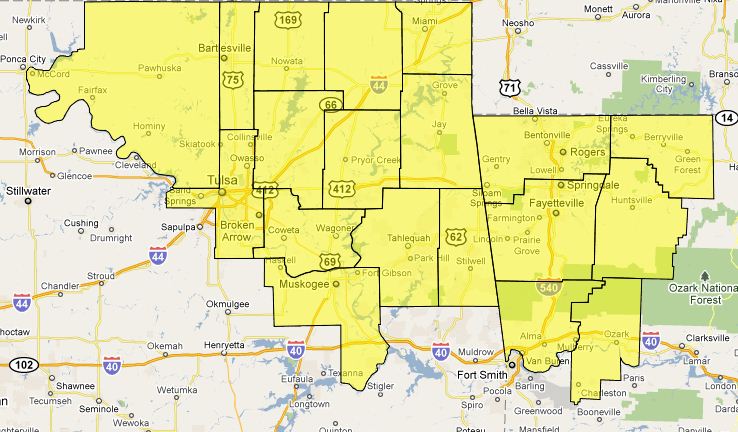 Current radar: 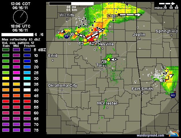
Risk of Severe Weather This AfternoonI hope everyone enjoyed the early morning and unexpected storms even though the wake up call was a tad early, at least
for me.
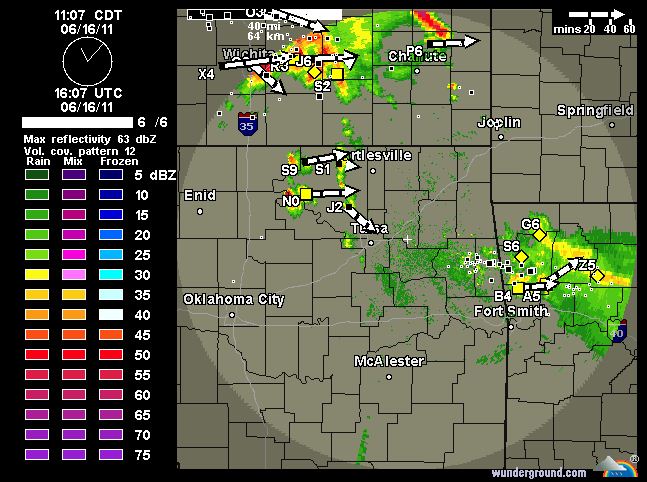
A threat of severe weather remains this afternoon as another complex has formed and is moving SE through
central Kansas as some storms trying to develop west and northwest of Tulsa.
Here is the SPC risk map for today:
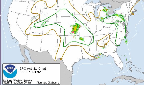
Here is the current local radar:
Tuesday, June 14, 2011
Severe Thunderstorm Watch IssuedNWS STORM PREDICTION CENTER NORMAN OK 530 PM CDT TUE JUN 14 2011 SEVERE THUNDERSTORM WATCH 476 IS IN
EFFECT UNTIL 1200 AM CDT FOR THE FOLLOWING LOCATIONS . OKLAHOMA COUNTIES INCLUDED ARE CADDO CANADIAN
CARTER CHEROKEE CLEVELAND
COMANCHE COTTON CRAIG
CREEK DELAWARE GARVIN
GRADY HUGHES JACKSON
JEFFERSON KIOWA LINCOLN
LOGAN MAYES MCCLAIN
MCINTOSH MURRAY MUSKOGEE
NOWATA OKFUSKEE OKLAHOMA
OKMULGEE OSAGE OTTAWA
PAWNEE PAYNE PONTOTOC
POTTAWATOMIE ROGERS SEMINOLE
STEPHENS TILLMAN TULSA
WAGONER WASHINGTON The watch area is in yellow below: 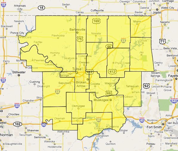
A Slight Risk of Severe Weather for NE Oklahoma Remains for This EveningA slight risk of severe weather remains for this evening and possibly during the overnight hours across NE Oklahoma. Storms
have begun to form west of Tulsa and should continue to expand in coverage as the evening progresses with storms possibly
affecting the Tulsa area as early as 6:00pm. Damaging winds are the primary threat along with a slight chance
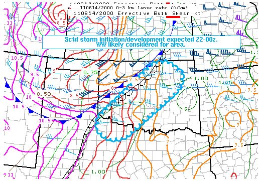
of hail up to the size of tennis balls. Here is the current SPC severe weather risk graphic for this evening: 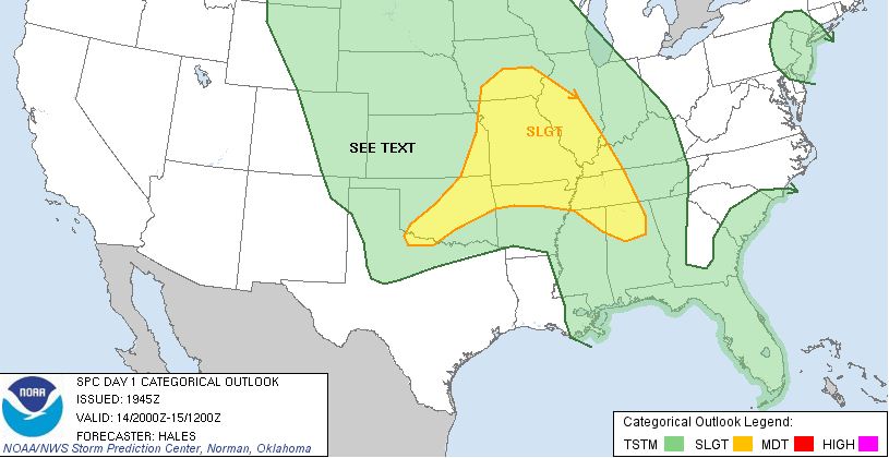 And, the Tulsa NWS highest probable wind gust graphic in MPH for the evening. 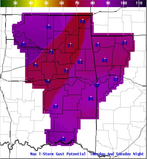 A
Severe Thunderstorm Watch will likely be issued for the area in the next hour.
The SPC graphic below shows
the likely area for the watch inside the blue oval.
Slight Risk of Severe Weather This EveningThere is a slight risk of severe weather tonight across most of NE Oklahoma. Damaging winds appear to the primary threat
with these storms that, if they form, will most likely affect the Tulsa area after 6:00. There is a good
chance we will see storms this evening and get some much needed rain. Here is the SPC risk map for today: 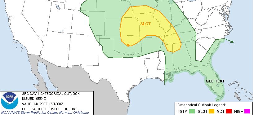 Here is the max possible wind gusts from the Tulsa NWS for this evening. This is noted in MPH. 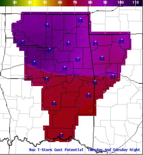
Sunday, June 12, 2011
Severe Thunderstorm Watch IssuedA Severe Thunderstorm Watch has been issued for parts of NE Oklahoma. Damaging winds and hail to the size of golfballs
are possible with any storms.
A line of strong to severe storms storms is currently along I=35 from the Kansas
border to Oklahoma City and SW moving east. These storms will likey be severe when they enter the Tulsa area after 2:30 with
damaging winds likely. If they begin to fall apart near Tulsa, damaging winds remain possible.
Here is the NWS
Watch:
THE NATIONAL WEATHER SERVICE HAS ISSUED SEVERE THUNDERSTORM WATCH
466 IN EFFECT UNTIL 6 AM CDT EARLY
THIS MORNING FOR THE FOLLOWING
AREAS
IN OKLAHOMA THIS WATCH INCLUDES 18 COUNTIES
IN EAST CENTRAL
OKLAHOMA
CHEROKEE MUSKOGEE
OKFUSKEE
IN NORTHEAST OKLAHOMA
ADAIR CRAIG
CREEK
DELAWARE
MAYES NOWATA
OKMULGEE OSAGE
OTTAWA
PAWNEE
ROGERS TULSA
WAGONER WASHINGTON
Here is a graphical representation of the watch:
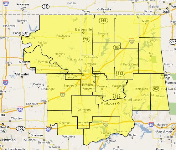
Please stay tuned to local NWS Radio, KRMG 102.3FM/740AM or televised media for later updates and
possible warnings.
Saturday, June 11, 2011
Slight Risk of Severe Weather TodayThere is a slight risk of severe weather today across all of NE Oklahoma. Winds to 60MPH and hail to the size of
tennis balls are possible in the area. Storms could form in the Tulsa area as early as 3:00pm. Here is the
SPC risk map for today: 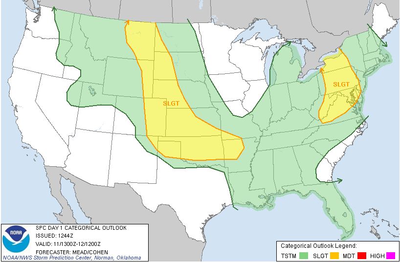
Friday, June 10, 2011
Severe Thunderstorm Watch Issued North and West of TulsaNATIONAL WEATHER SERVICE TULSA OK THE NATIONAL WEATHER SERVICE HAS ISSUED SEVERE THUNDERSTORM WATCH 458 IN
EFFECT UNTIL MIDNIGHT CDT TONIGHT FOR THE FOLLOWING AREAS IN NORTHEAST OKLAHOMA CRAIG
NOWATA OSAGE
OTTAWA PAWNEE
WASHINGTON THIS INCLUDES THE CITIES OF...BARTLESVILLE...MIAMI...NOWATA... PAWHUSKA...PAWNEE AND VINITA. Large hail and damaging winds are the primary threats. Storm should
remain west of Tulsa through 11:00PM 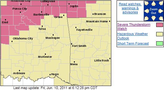
Slight Risk of Severe Weather TodayThere is a slight risk of severe weather across parts NE Oklahoma today. Damaging winds will be the primary
threat. Here is the SPC severe weather risk map for today: 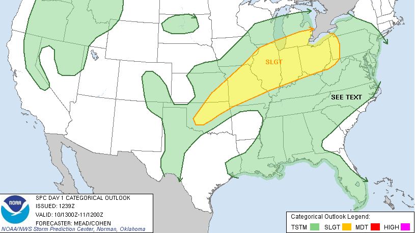 Not everyone in the threat area are expected to see storms today and there is a slightly better chance of rain
and thunderstorms on Saturday.
|