|
Wednesday, April 27, 2011
Some Storms Likely Today, Possibly with Some Small Hail.There wiill be some storms in the area today with small hail possible. After today, we get a break until Saturday when more
rain and storms will be possible.
Rainfall amounts today will generally be less than 1/4 inch but may be
as much as 1/2 inch in the strongest storms.
Hopefully this will be the last update for a few days!
Wed, April 27, 2011 | link
Tuesday, April 26, 2011
Severe Weather Possible This Evening, Overnight, and into Early Wednesday MorningThere remains a slight risk of severe weather for NE Oklahoma with that threat increasing dramatically SE of I-40. For the
Tulsa area, large hail, damaging winds, and locally heavy rainfall are the primary threats. Some showers may be
in the area as early as 6:00PM but the round of severe storms will likely hold off until after 10:30PM. Here
is the SPC risk graphic for today. A major severe weather outbreak including multiple tornados is expected in the HIGH risk
area in far SE OK, NE Texas, Arkansas, Lousiana, Mississippi, and Tennessee. 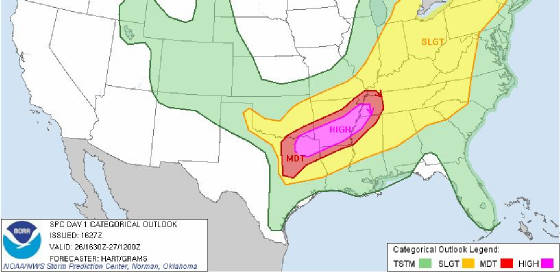 Here is a model image of the simulated radar for 11:00PM this evening with strong to severe storms crossing
highway 75. 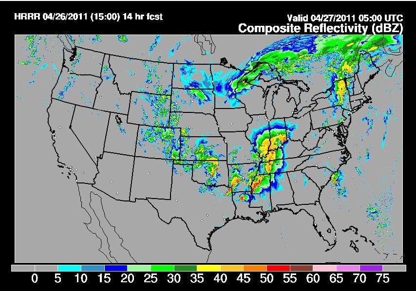 Things are expected to quiet down Wednesday afternoon through at least Friday night before another round
of severe storms comes through on Saturday.
More Severe Weather Expected This Evening. Especially Across SE OklahomaSevere storms with large hail, damaging wind, and locally heavy rainfall are expected across NE Oklahoma this evening and
overnight, mainly after 6:00pm. A significant severe weather outbreak is possible across SE Oklahoma this evening with tornado's
a good possibility. River flooding is on-going in far Eastern Oklahoma and any additional rain will only increase
the problems in those areas so please be very aware if traveling in those area and do not drive through water flowing
across a road as it only take a few inches of moving water to move your vehicle. Here is the SPC severe weather
threat graphic for today. This will likely be updated this afternoon and I will send that out in a later update. 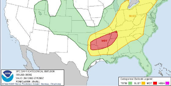
Monday, April 25, 2011
Severe Weather Threat Continues Today that will Aggravate Current Flooding IssueThere is a slight risk of severe weather across all of Eastern Oklahoma today with areas south of I-44 most at risk in this
area. Large hail, damaging winds, heavy rains, and tornado's are all possible with the tornadic threat increasing
in southeast Oklahoma. The line of severe storms are expected to form along the I-44 corridor around around 3:00
PM today. Here is the SPC risk map for today: 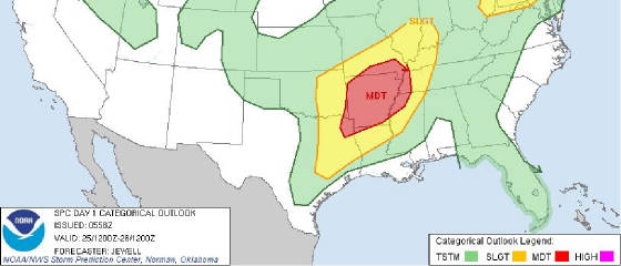 Here is the 4 day rainfall total map: 
Sunday, April 24, 2011
Severe Thunderstorm Watch Issued A Severe Thunderstorm Watch has been issued for areas roughly South of I-44. This includes the Tulsa area. Large hail, damaging
winds, and locally heavy rainfall can be expected in the watch area. A Flash Flood Watch is also in effect for
areas East of highway 75. Here is the Tulsa NWS watches and warnings graphic: 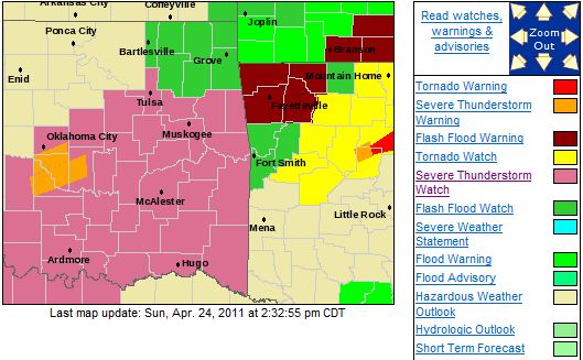 EFFECTIVE THIS SUNDAY AFTERNOON AND EVENING FROM 230 PM UNTIL 900 PM CDT. HAIL TO 3 INCHES IN
DIAMETER...THUNDERSTORM WIND GUSTS TO 70 MPH...AND DANGEROUS LIGHTNING ARE POSSIBLE IN THESE AREAS. THE SEVERE
THUNDERSTORM WATCH AREA IS APPROXIMATELY ALONG AND 55 STATUTE MILES NORTH AND SOUTH OF A LINE FROM 55 MILES WEST OF ARDMORE OKLAHOMA TO 20 MILES NORTH NORTHEAST OF POTEAU OKLAHOMA. FOR A COMPLETE DEPICTION OF THE WATCH SEE THE ASSOCIATED
WATCH OUTLINE UPDATE (WOUS64 KWNS WOU4). REMEMBER...A SEVERE THUNDERSTORM WATCH MEANS CONDITIONS ARE FAVORABLE
FOR SEVERE THUNDERSTORMS IN AND CLOSE TO THE WATCH AREA. PERSONS IN THESE AREAS SHOULD BE ON THE LOOKOUT FOR THREATENING
WEATHER CONDITIONS AND LISTEN FOR LATER STATEMENTS AND POSSIBLE WARNINGS. SEVERE THUNDERSTORMS CAN AND OCCASIONALLY DO PRODUCE TORNADOES.
Severe Weather and Flooding Likely TodayThere is a slight risk of severe weather across most of the area today with large hail, damaging winds, and heavy rain being
the primary threats although there is a slight tornado risk in far SE Oklahoma. Flooding has been an issue this
morning especially across far eastern Oklahoma. The risk for flooding will be on-going across the area today, especially for
areas just south and east of Tulsa. The Illinois River at Tahlequah is currently over 5 feet above flood stage
and is expected to continue rising. Rain is expected to fall off and on throughout the day today. Here
is the SPC severe weather risk area: 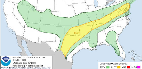 Here is the Tulsa NWS map of potential rainfall amounts today and tonight: 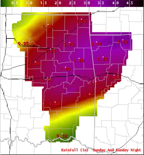 : The threat for severe weather and heavy rain could continue through Tuesday.
Saturday, April 23, 2011
Severe Thunderstorm Watch has been IssuedA Severe Thunderstorm
Watch is in effect for all of NE Oklahoma until 5:00 AM.
Here is the NWS watch graphic indicating the watch area.
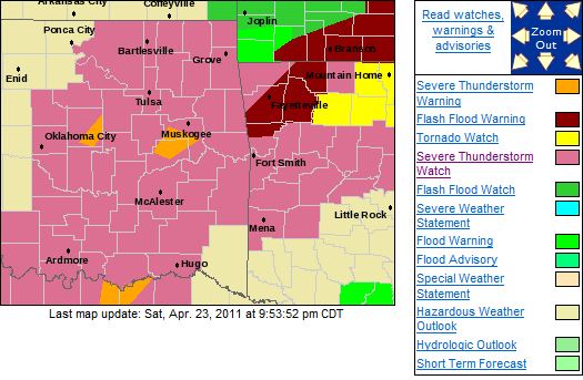
A Flash Flood Watch remains in effect. Here are some Flash Flood safety rules to review.
Flash Flood Safety Rules ·
Avoid walking, swimming, or driving in flood waters. ·
Stay away from high water, storm drains, ditches,
ravines, or culverts. If it is moving ·
swiftly, even water six inches deep can knock you
off your feet. ·
If you come upon flood waters, stop, turn around,
and go another way. ·
Climb to higher ground. ·
Do not let children play near storm drains. Here is the Oklahoma
Mesonet 4 day rainfall total graphic. This will automatically update every 15 minutes.
Storms Reforming Around Tulsa. A Severe Thunderstorm Watch PossibleStorms are beginning to form that could possibly become severe later this evening with large hail, damaging winds, and heavy
rain possible. A Flash Flood Watch is in effect for Tulsa and areas to the east. Here is the possible watch area. 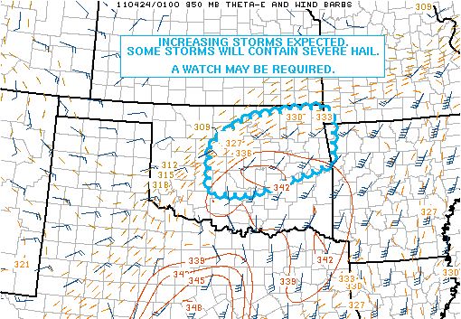 Here are all of the current watches and warnings. 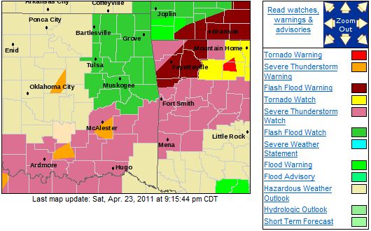
Flash Flood Watch In Effect Through Monday EveningTHE NATIONAL WEATHER SERVICE IN TULSA HAS ISSUED A * FLASH FLOOD WATCH FOR PORTIONS OF ARKANSAS AND OKLAHOMA... INCLUDING THE FOLLOWING AREAS...IN ARKANSAS...BENTON... CARROLL...CRAWFORD...FRANKLIN...MADISON...SEBASTIAN AND WASHINGTON. IN OKLAHOMA...ADAIR...CHEROKEE...CRAIG... DELAWARE...HASKELL...MAYES...MUSKOGEE...NOWATA...OTTAWA... ROGERS...SEQUOYAH...TULSA...WAGONER AND WASHINGTON. 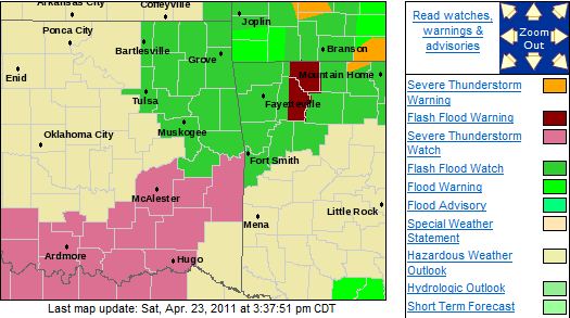 * THROUGH MONDAY EVENING * A SERIES OF UPPER DISTURBANCES... IN CONJUNCTION WITH A
STATIONARY FRONT POSITIONED ACROSS THE AREA WILL BRING SEVERAL ROUNDS OF HEAVY RAINFALL TO THE AREA OVER THE NEXT
FEW DAYS. RAINFALL TOTALS WILL INCREASE QUICKLY IN AREAS WITH SLOW MOVING STORMS OR TRAINING OF CELLS.
Severe Threat Has Ended for This EveningA slight threat of severe storms remains for Saturday with heavy rain possilbe Saturday evening.
Friday, April 22, 2011
Severe Thunderstorm Watch Issued East of Tulsa, More of Oklahoma to be Possibly IncludedA Severe Thunderstorm Watch was issued for areas east of Tulsa earlier. Conditions are developing that may require a
watch be issued for much more of Oklahoma. Damaging winds, large hail, and locally heavy can be expected in the watch
area and the potential watch area if storms develop as expected. Here is the current watch area in pink. The
yellow is a tornado watch.  Here is a graphic from the SPC indicating the potential watch area. 
Tornado Watch Cancelled. More storms expected over the weekend but Tornado threat is low.There remains a threat for severe weather off and on throughout the weekend. Over the next
several days, there are numerous chances of severe thunderstorms with locally heavy rain, large hail, and damaging winds
being the primary threats.
There also appears to be a potential for flooding rains across the area, especially
late Saturday and Sunday where up to 3 inches of rain could fall across most of the area during those
two days. This would be in addition to any rain that has fallen so far and that falls today. A Flash Flood Watch will
likely be issued at some point this evening or tomorrow morning. Here is the latest SPC severe weather risk map
for Saturday: 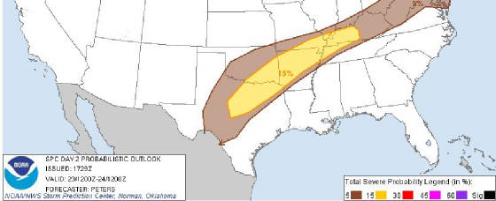 Here is the Oklahoma Mesonet 4 day rainfall map. This will automatically be updated every 15 minutes.
This and other maps on available on the Current Conditions page of this blog here: http://www.tulsagoldenhurricane.com/id11.html
Tornado Watch Issued
Fri, April 22, 2011 | link
Severe Weather Threat Remains. Moderate Risk South and East of TulsaQuick update with the upgrade from Slight to Moderate Risk south and east of Tulsa. There remains a threat
for severe weather late this afternoon with heavy rain, large hail, damaging winds, and possibly a tornado, especially SE
of I-44. This area has been placed in a Moderate Risk category for late this afternoon. Over
the next several days, there are numerous chances of severe thunderstorms with locally heavy rain, hail to the size of
baseballs, and damaging winds being the primary threats although the most significant chance of severe weather is from 4:00PM to 10:00PM
this evening.
There also appears to be a potential for flooding rains across the area, especially
Saturday and Sunday where up to 2 inches of rain could fall across most of the area. This would be in addition to
any rain that has fallen so far and that falls today. A Flash Flood Watch will likely be issued at some point this evening
or tomorrow morning. Here is the latest SPC severe weather risk map for today: 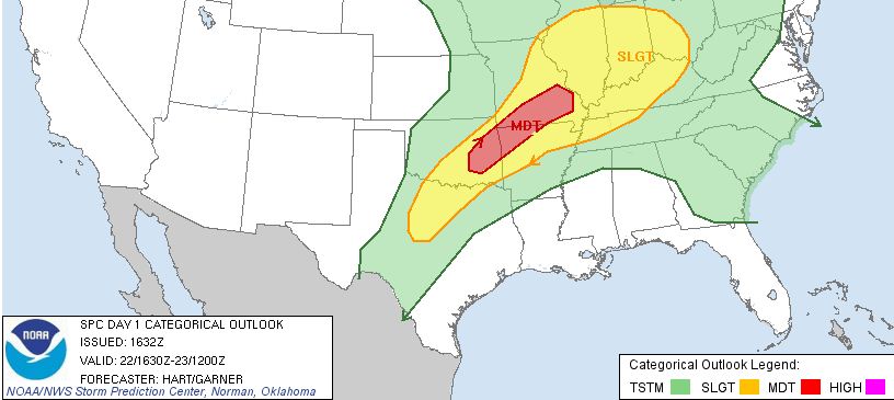 Here is the Oklahoma Mesonet 4 day rainfall map. This will automatically be updated every 15 minutes.
This and other maps on available on the Current Conditions page of this blog here: http://www.tulsagoldenhurricane.com/id11.html
Severe Weather and Heavy Rain PossibleThere is a threat for severe weather late this afternoon with heavy rain, large hail, damaging winds, and possibly a tornado,
especially SE of I-44. Over the next several days, there are numerous chances of severe thunderstorms
with locally heavy rain, hail to the size of baseballs, and damaging winds being the primary threats although the most significant chance
of severe weather is from 4:00PM to 10:00PM this evening.
There also appears to be a potential for
flooding rains across the area, especially Saturday and Sunday where up to 2 inches of rain could fall across most
of the area. This would be in addition to any rain that has fallen so far and that falls today. A Flash Flood Watch will
likely be issued at some point this evening or tomorrow morning. Here is the SPC severe weather risk map for today: 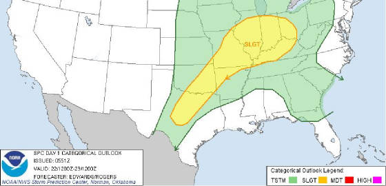 Here is the Oklahoma Mesonet 4 day rainfall map. This will automatically be updated every 15
minutes. This and other maps on available on the Current Conditions page of this blog here: http://www.tulsagoldenhurricane.com/id11.html
Thursday, April 21, 2011
Severe Thunderstorm Watch Issued for Areas East of TulsaThe severe thunderstorm watch is in effect until 10:00pm. Large hail, damaging winds, and locally heavy rain are possible
in these areas. Here is the watch area. 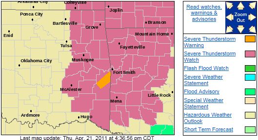
Severe Weather Remains Possible This Afternoon and EveningStorms are expected to form this afternoon across NE Oklahoma. A few of these storms could become severe with heavy rain,
damaging winds, and large hail. Here is this afternoon and evenings risk map from the SPC.  There is a greater risk of severe weather on Friday with large hail, damaging winds, and the possibility
of isolated tornados. Here is Friday's severe weather risk area from the SPC. 
Wednesday, April 20, 2011
Severe Weather Possible Each of the Next Several DaysThere is a threat of severe weather Thursday evening and Friday evening with large hail and damaging winds being
the primary threat. Locally heavy rainfall will also be possible with any of the storms that form. Showers
look to be around Thursday morning but these are not expected to be severe at this time. Here is the SPC severe
threat risk graphic for Thursday:  Here is the SPC risk graphic for Friday:  At this time it appears storms will continue off and on each day through at least Easter. Updates
to follow...
Tuesday, April 19, 2011
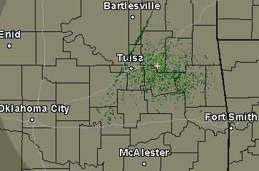
Severe Weather Threat UpdateThe cold
front is arriving slightly ahead of schedule and should pass through Tulsa in the next 20-30 minutes thus the
threat of severe weather for the Tulsa metro area should end in the next hour.
The line you see up and to the left of Tulsa in the 10:50 am radar image below is the cold
front.
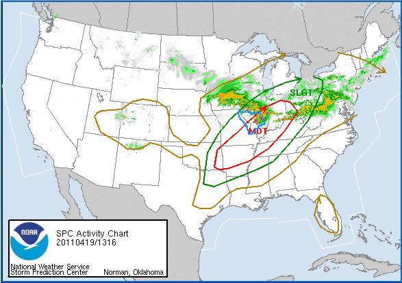
Risk of Severe Weather This AfternoonThere remains a risk of severe weather
but at this time it appears the highest chances are east of the Tulsa area.
Showers may form along the cold front as it enters the
Tulsa area between 11:00 and 1:00 today and intensify as the line tracks to the SE.
Here is the SPC map of the
risk area:
Here is an image of the
simulated radar at noon today showing showers developing along the cold front.

And, at 4:00pm
showing severe storms beginning to form south of Tulsa. This entire line of storms will likely be severe as it pushes out
of Oklahoma.

Updates to follow if required.
Monday, April 18, 2011
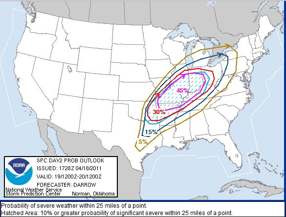
There is a Risk of Severe Weather on TuesdayThere is a risk of severe weather for all of eastern Oklahoma on Tuesday.
Large hail, damaging winds, and
an isolated tornado are possible in areas east of highway 75 after 6:00 PM on Tuesday.
Updates to follow...
Friday, April 15, 2011
WIND ADVISORY IN EFFECT UNTIL 10 PM CDT THIS EVENINGURGENT - WEATHER MESSAGE
NATIONAL WEATHER SERVICE TULSA OK
1109 AM CDT FRI APR 15 2011
...WIND ADVISORY
IN EFFECT UNTIL 10 PM CDT THIS EVENING...
THE NATIONAL WEATHER SERVICE IN TULSA HAS ISSUED A WIND ADVISORY...
WHICH IS IN EFFECT UNTIL 10 PM CDT THIS EVENING...
FOR THE FOLLOWING COUNTIES...
* IN OKLAHOMA...WASHINGTON...CREEK...OKFUSKEE...OKMULGEE
AND
TULSA.
HAZARDOUS WEATHER...
* LOW PRESSURE OVER KANSAS WILL BRING STRONG WESTERLY
WINDS TO
PARTS OF NORTHEAST OKLAHOMA THROUGH THE AFTERNOON AND INTO THE
EVENING.
IMPACTS...
* WIND GUSTS UP TO 45 MPH ARE POSSIBLE.
* WINDS THIS STRONG CAN MAKE DRIVING DIFFICULT...ESPECIALLY
FOR
HIGH PROFILE VEHICLES.
DEFINITION...
* A WIND ADVISORY MEANS THAT WIND GUSTS OF 40
MPH ARE EXPECTED.
PRECAUTIONARY/PREPAREDNESS ACTIONS...
* MOTORISTS SHOULD EXERCISE CAUTION WHILE DRIVING.
BE ALERT TO
SUDDEN GUSTS OF WIND WHICH MAY CAUSE YOU TO LOSE CONTROL OF YOUR
VEHICLE.
EXTRA ATTENTION SHOULD BE GIVEN TO CROSS WINDS AND ON
BRIDGES AND OVERPASSES.
Fri, April 15, 2011 | link
Thursday, April 14, 2011
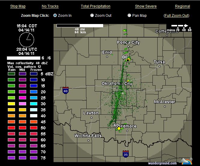
Storms have begun to form East of OKC These should increase in intensity rapidly
and are tracking towards Tulsa.
***Particularly Dangerous Situation (PDS) Tornado Watch Issued***From the National Weather Service in Tulsa 
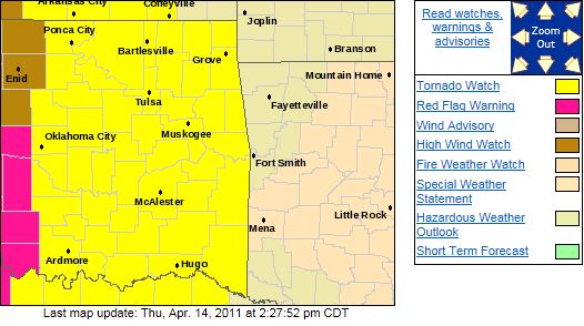
As more data comes the possibility of
extremely large hail, very damaging winds, and large, long tracked, tornadoes across eastern Oklahoma is increasing.
A Particularly Dangerous Situation (PDS) Tornado Watch
has been issued for all of eastern Oklahoma Effective until 10:00PM
...THIS IS A PARTICULARLY DANGEROUS
SITUATION...
DESTRUCTIVE TORNADOES...LARGE HAIL TO 4 INCHES IN
DIAMETER...
THUNDERSTORM WIND GUSTS TO 80 MPH...AND DANGEROUS LIGHTNING ARE
POSSIBLE IN
THESE AREAS.
REMEMBER...A TORNADO WATCH MEANS CONDITIONS ARE FAVORABLE FOR
TORNADOES AND SEVERE THUNDERSTORMS IN AND CLOSE TO THE WATCH
AREA. PERSONS IN THESE AREAS
SHOULD BE ON THE LOOKOUT FOR
THREATENING WEATHER CONDITIONS AND LISTEN FOR LATER STATEMENTS
AND POSSIBLE WARNINGS.
If
you have any outdoor activities planned, please pay extremely close attention to the local media.
If you
will be attending an outdoor event this evening, please bring a battery powered radio and tune to AM740/FM102.3 KRMG for the
latest updates, watches, and warnings.
I will likely not
be issuing any more updates on this dangerous situation as I prefer everyone stay tuned to the local media for the most up
to date information.
Moderate Risk of Severe Weather in Tulsa, Greater Risk in SE OK.A potentially significant break of severe weather is still expected this evening.
Supercells with hail to the size
of baseballs, wind gusts to 80MPH, and possibly tornado's (including the threat for large tornado's) are expected
to approach the Tulsa area by 7:00pm this evening or possibly earlier. Some models are beginning to indicate the most significant
severe weather threat will be in SE Oklahoma but that severe weather is still expected across all of eastern Oklahoma.
There are many baseball games scheduled this evening for kids of all ages.
Please pay close attention to the local media for any watches or warnings that will be issued for your area and do not hesitate
to end a game early or call a game off if warning is issued for your area or for an area within 40 miles of you as lightning
strikes can occur away from the primary storm and families will need ample time to seek shelter.
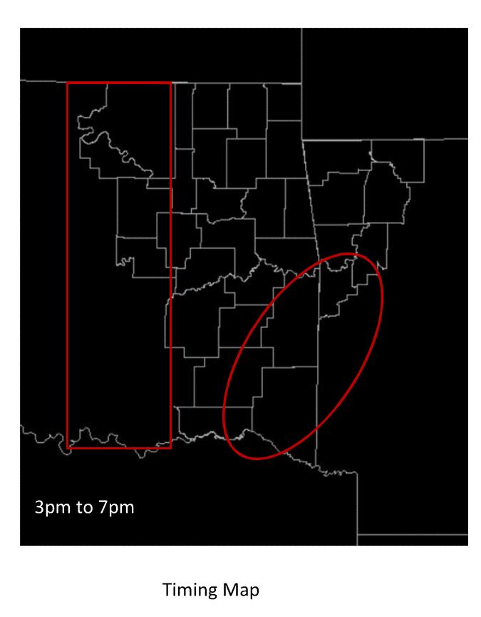
Here
is a Tulsa NWS graphic indicating the times storms can be expected. The red line closest and to the left of Tulsa indicates
the closest the storms are expected to be to Tulsa at 7:00pm.
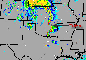
Here is the latest simulated radar graphic for 6:00pm this evening indicating storms could be just south and northwest
of Tulsa.
Updates to follow...
Tulsa NWS Release: REVIEW OF SEVERE WEATHER SAFETY RULESPUBLIC INFORMATION STATEMENT
NATIONAL WEATHER SERVICE TULSA OK
809 AM CDT THU APR 14 2011
...REVIEW OF SEVERE WEATHER SAFETY RULES...
AN OUTBREAK OF SEVERE
THUNDERSTORMS...INCLUDING THE POTENTIAL FOR
TORNADOES...IS EXPECTED ACROSS PORTIONS OF EASTERN OKLAHOMA AND
NORTHWEST
ARKANSAS LATER TODAY. RESIDENTS ACROSS THE REGION SHOULD
MONITOR THIS SITUATION VERY CLOSELY. WATCHES AND WARNINGS WILL
LIKELY BE ISSUED LATER TODAY. HERE ARE SOME SAFETY RULES TO KEEP IN
MIND WHEN SEVERE WEATHER IS EXPECTED OR IS
OCCURRING.
BEFORE SEVERE WEATHER STRIKES...ENSURE THAT YOU AND YOUR FAMILY
ARE FULLY PREPARED. IN A HOME OR
BUILDING HAVE A PRE-DESIGNATED
SHELTER... SUCH AS A BASEMENT OR AN INTERIOR ROOM OR HALLWAY.
HAVE ON HAND A DISASTER
SUPPLY KIT...INCLUDING A NOAA WEATHER
RADIO...FLASHLIGHT...RADIO AND A GOOD SUPPLY OF BATTERIES.
IF A SEVERE
THUNDERSTORM OR TORNADO WARNING IS ISSUED...SEEK SHELTER
INDOORS IMMEDIATELY. A SEVERE THUNDERSTORM IS DEFINED AS PRODUCING
PENNY SIZE OR GREATER HAIL AND WIND GUSTS OF 58 MPH OR MORE. IN
EXTREME CASES...SEVERE THUNDERSTORMS CAN PRODUCE WINDS
TO NEAR 150
MPH AND HAIL LARGER THAN GRAPEFRUITS WHICH CAN CAUSE EXTENSIVE
PROPERTY DAMAGE.
TORNADOES
OFTEN FORM VERY RAPIDLY FROM SEVERE THUNDERSTORMS. IF
YOU ARE IN A TORNADO WATCH...AND A SEVERE THUNDERSTORM WARNING
IS
ISSUED FOR YOUR AREA...MONITOR LOCAL CONDITIONS CLOSELY AND BE
READY TO TAKE QUICK ACTION TO SAVE YOUR LIFE.
REMEMBER THAT LIGHTNING IS A THUNDERSTORMS MOST UNDERRATED KILLER.
POSTPONE
OUTDOOR ACTIVITIES IF THUNDERSTORMS ARE IMMINENT. THIS
IS THE BEST WAY TO AVOID BEING CAUGHT IN A DANGEROUS SITUATION.
AUTOMOBILES OFFER GOOD PROTECTION FROM LIGHTNING...ALTHOUGH MOVING
INDOORS IS BEST. EVEN INSIDE...LIGHTING CAN KILL
BY COMING THROUGH
THE PHONE LINES...PLUMBING AND ELECTRIC LINES. THEREFORE DO NOT
USE COMPUTERS...TELEPHONES OR
OTHER HAND HELD APPLIANCES DURING A
STORM.
STAY TUNED TO NOAA WEATHER RADIO...COMMERCIAL RADIO OR TELEVISION
FOR THE LATEST ON THIS DEVELOPING SEVERE WEATHER EVENT. ADDITIONAL
WEATHER INFORMATION...INCLUDING RELATED GRAPHICS
CAN BE FOUND AT
WEATHER.GOV/TULSA.
Thu, April 14, 2011 | link
There is a Moderate Risk of Severe Storms Late This Afternoon and Especially This EveningThere is a moderate risk of severe weather for essentially all of eastern Oklahoma. Storms are expected to begin firing just
west of I-35 around 5:30 and will begin tracking towards eastern Oklahoma. These storms will start out as individual supercells
with the threat of hail to the size of baseballs, strong, damaging winds, and tornado's. As the storms track
east past Tulsa this evening after 8:00, they will likely form into a solid line of severe storms
with large hail and damaging winds being the primary threat with a slight possibility of an embedded tornado. Here is the SPC's risk graphic for today  Here is an image of what radar is expected to look like at 9:00 pm this evening.  Updates to follow...
Wednesday, April 13, 2011
Severe Storms Expected Thursday An outbreak of severe weather is expected Thursday evening after 6:00 in the Tulsa area.
Large hail, damaging winds,
and tornadoes are expected.
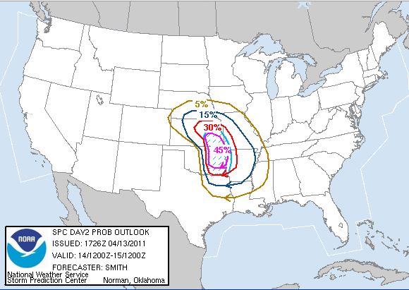
The risk area hasn't changed much since this morning but here is the latest SPC
Severe Weather probabilities map:
Updates to follow...
MODERATE Risk of Severe Weather in NE Oklahoma on ThursdayThings are setting up for a severe weather outbreak across NE Oklahoma Thursday evening. Large hail, damaging winds, and tornados
are all possible. Supercells are expected to form along the dryline west of I-35 late Thursday afternoon and track
east and northeast into eastern Oklahoma Thursday night. Here is the Storm Prediction Center's Moderate
Risk Area: 
FIRE DANGER STATEMENTFIRE DANGER STATEMENT NATIONAL WEATHER SERVICE TULSA OK 411 AM CDT WED APR 13 2011 ...VERY HIGH FIRE
DANGER... THE NATIONAL WEATHER SERVICE IN TULSA HAS ISSUED A FIRE WEATHER ALERT WHICH IS IN EFFECT UNTIL 900
PM CDT FOR THE FOLLOWING COUNTIES... IN OKLAHOMA... OSAGE...WASHINGTON...NOWATA...CRAIG...OTTAWA...PAWNEE...TULSA... ROGERS...MAYES...DELAWARE...CREEK...OKFUSKEE...OKMULGEE...WAGONER... CHEROKEE...MUSKOGEE AND MCINTOSH. 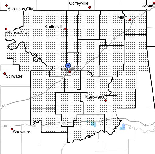 AFTERNOON TEMPERATURES IN THE UPPER 70S TO LOWER 80S COMBINED WITH SOUTH WINDS INCREASING TO 10 TO 20 MILES
AN HOUR WILL RESULT IN A VERY HIGH FIRE DANGER TODAY. HUMIDITY LEVELS WILL FALL INTO THE 20 TO 30 PERCENT RANGE
THIS AFTERNOON. ANY FIRES THAT DO IGNITE WILL SPREAD RAPIDLY TODAY. BURN BANS ARE IN EFFECT FOR OSAGE...PAWNEE...CREEK...TULSA... OKFUSKEE...OKMULGEE...CRAIG AND DELAWARE COUNTIES IN NORTHEAST OKLAHOMA. A FIRE WEATHER ALERT IS ISSUED
WHEN DANGEROUS FIRE WEATHER CONDITIONS ARE EXPECTED BUT ARE BELOW RED FLAG CRITERIA. A FIRE WEATHER ALERT MAY ALSO
BE ISSUED TO RELAY STATE OR COUNTY FIRE INFORMATION...SUCH AS BURNING BANS.
Tuesday, April 12, 2011
Severe Weather Threat on ThursdayThere is a risk of severe weather Thursday afternoon and evening with large hail, damaging winds, and tornadoes all possible. Here is the SPC Day 3 Outlook Graphic: 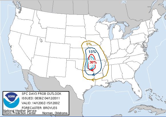 Stayed turned for further updates.
Monday, April 11, 2011
Very High Fire Danger for Eastern OklahomaFIRE DANGER STATEMENT NATIONAL WEATHER SERVICE TULSA OK 932 AM CDT MON APR 11 2011 ...VERY HIGH
FIRE DANGER... THE NATIONAL WEATHER SERVICE IN TULSA HAS ISSUED A FIRE WEATHER ALERT WHICH IS IN EFFECT UNTIL
700 PM CDT FOR THE FOLLOWING COUNTIES... IN OKLAHOMA... OSAGE...WASHINGTON...NOWATA...CRAIG...OTTAWA...PAWNEE...TULSA... ROGERS...MAYES...DELAWARE...CREEK...OKFUSKEE...OKMULGEE AND WAGONER. 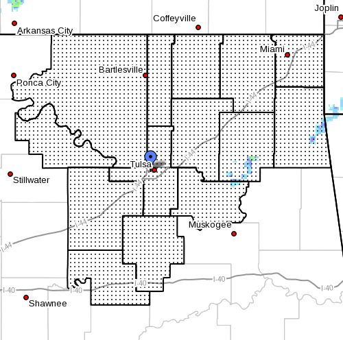 NORTHWESTERLY WINDS OF 15 TO 25 MPH WITH GUSTS AROUND 30 MPH WILL CONTINUE THROUGH THE AFTERNOON.
THESE WINDS COMBINED WITH VERY DRY CONDITIONS WILL PROMOTE AGGRESSIVE FIRE SPREAD. WINDS WILL DIMINISH TOWARD
SUNSET. A FIRE WEATHER ALERT IS ISSUED WHEN DANGEROUS FIRE WEATHER CONDITIONS ARE EXPECTED BUT ARE BELOW RED
FLAG CRITERIA. A FIRE WEATHER ALERT MAY ALSO BE ISSUED TO RELAY STATE OR COUNTY FIRE INFORMATION...SUCH AS BURNING BANS.
Sunday, April 10, 2011
Tornado Watch Issued for County's South and East of TulsaTHE NATIONAL WEATHER SERVICE HAS ISSUED TORNADO WATCH 124 IN EFFECT UNTIL 3 AM CDT MONDAY FOR THE FOLLOWING AREAS IN ARKANSAS THIS WATCH INCLUDES 7 COUNTIES IN NORTHWEST ARKANSAS BENTON
CARROLL CRAWFORD
MADISON WASHINGTON
IN WEST CENTRAL ARKANSAS FRANKLIN
SEBASTIAN IN OKLAHOMA THIS WATCH INCLUDES
17 COUNTIES IN EAST CENTRAL OKLAHOMA CHEROKEE
MUSKOGEE OKFUSKEE
SEQUOYAH IN NORTHEAST OKLAHOMA ADAIR DELAWARE
MAYES OKMULGEE
OTTAWA WAGONER
IN SOUTHEAST OKLAHOMA CHOCTAW
HASKELL LATIMER
LE FLORE MCINTOSH
PITTSBURG PUSHMATAHA
THIS INCLUDES THE CITIES OF...ANTLERS...BENTONVILLE... BERRYVILLE...CHARLESTON...CLAYTON...EUFAULA...EUREKA
SPRINGS... FAYETTEVILLE...FORT SMITH...HUGO...HUNTSVILLE...JAY...MCALESTER... MIAMI...MUSKOGEE...OKEMAH...OKMULGEE...OZARK...POTEAU...PRYOR... ROGERS...SALLISAW...SPRINGDALE...STIGLER...STILWELL...TAHLEQUAH... VAN BUREN...WAGONER AND WILBURTON. 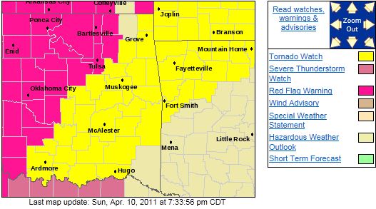
CRITICAL FIRE DANGER LIKELY IN PARTS OF NORTHEAST OKLAHOMAURGENT - FIRE WEATHER MESSAGE NATIONAL WEATHER SERVICE TULSA OK 328 PM CDT SUN APR 10 2011 ...CRITICAL
FIRE DANGER LIKELY IN PARTS OF NORTHEAST OKLAHOMA TODAY... .A DRYLINE CONTINUES TO PUSH ACROSS CENTRAL AND
EASTERN OKLAHOMA THIS AFTERNOON...WITH GUSTY SOUTHWEST WINDS AND LOW RELATIVE HUMIDITIES BEING OBSERVED BEHIND THE
BOUNDARY. THESE CONDITIONS WILL CONTINUE TO POTENTIALLY CREATE VERY DANGEROUS CONDITIONS FOR THE GROWTH AND SPREAD
OF WILDFIRES. ...RED FLAG WARNING REMAINS IN EFFECT UNTIL 10 PM CDT THIS EVENING... FOR THE FOLLOWING
COUNTIES... IN OKLAHOMA... OSAGE...WASHINGTON...NOWATA...PAWNEE...TULSA...ROGERS...CREEK... OKFUSKEE
AND OKMULGEE. 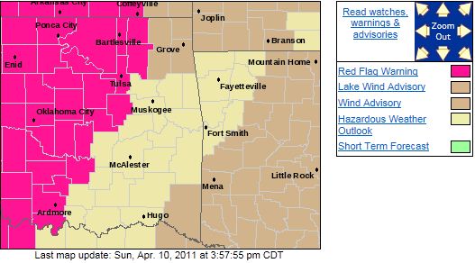 A DRYLINE WILL MOVE CONTINUE TO PUSH EAST ACROSS NORTHEAST OKLAHOMA THIS AFTERNOON AND EVENING. WEST TO SOUTHWEST WINDS...GUSTING TO AROUND 25 MILES AN HOUR WITH RELATIVE HUMIDITY VALUES OF NEAR OR JUST BELOW 25 PERCENT TO THE WEST
OF THE DRYLINE. HIGH SPREAD INDEX VALUES IN THE WARNING AREA INDICATES THE POTENTIAL FOR RAPID WILDFIRE GROWTH AND
SPREAD. OSAGE...PAWNEE...CREEK...OKFUSKEE...TULSA AND OKMULGEE COUNTIES ARE CURRENTLY IN A BURN BAN. OUTDOOR
BURNING OF ANY KIND IS PROHIBITED IN THESE AREAS. PRECAUTIONARY/PREPAREDNESS ACTIONS... A RED FLAG
WARNING MEANS THAT A DANGEROUS COMBINATION OF WEATHER CONDITIONS AND DRY VEGETATION IS EXPECTED WITHIN 24 HOURS... FAVORING RAPID GROWTH AND SPREAD OF ANY WILDFIRES. THE PRIMARY WEATHER FACTORS INCLUDE STRONGER WINDS...LOWER HUMIDITIES...AND WARMER TEMPERATURES.
Saturday, April 9, 2011
...CRITICAL FIRE DANGER POSSIBLE SUNDAY...URGENT - FIRE WEATHER MESSAGE NATIONAL WEATHER SERVICE TULSA OK 932 PM CDT SAT APR 9 2011 ...CRITICAL
FIRE DANGER POSSIBLE SUNDAY... .A DRYLINE AND PACIFIC FRONT WILL MOVE EAST ACROSS CENTRAL INTO EASTERN OKLAHOMA.
BY AFTERNOON...SOUTHWEST WINDS WILL INCREASE AND RELATIVE HUMIDITIES WILL BECOME VERY LOW...POTENTIALLY CREATING
VERY DANGEROUS CONDITIONS FOR THE GROWTH AND SPREAD OF WILDFIRES. ...FIRE WEATHER WATCH IN EFFECT FROM SUNDAY
MORNING THROUGH SUNDAY EVENING... THE NATIONAL WEATHER SERVICE IN TULSA HAS ISSUED A FIRE WEATHER WATCH...WHICH
IS IN EFFECT FROM SUNDAY MORNING THROUGH SUNDAY EVENING. FOR THE FOLLOWING COUNTIES... IN OKLAHOMA... WASHINGTON...NOWATA...TULSA...ROGERS
AND OKMULGEE. 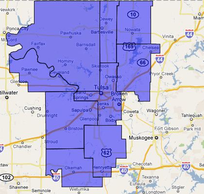 BASED ON THE LATEST MODEL DATA...A DRYLINE AND PACIFIC COLD FRONT ARE EXPECTED TO MOVE EAST TO AN OKMULGEE
TO CLAREMORE TO NOWATA LINE BY AFTERNOON. SOUTHWEST WINDS WILL INCREASE...GUSTING TO AROUND 30 MILES AN HOUR WITH
RELATIVE HUMIDITY VALUES OF NEAR OR JUST BELOW 20 PERCENT TO THE WEST OF THE FRONT AND DRYLINE. SPREAD INDEX VALUES
WILL BE NEAR 60 IN THE WATCH AREA WHICH INDICATES THE POTENTIAL FOR RAPID WILDFIRE GROWTH AND SPREAD. TULSA
AND OKMULGEE COUNTIES ARE CURRENTLY IN A BURN BAN. OUTDOOR BURNING OF ANY KIND IS PROHIBITED IN THESE AREAS. PRECAUTIONARY/PREPAREDNESS ACTIONS... A FIRE WEATHER WATCH IS ISSUED WHEN THE POTENTIAL FOR RED FLAG FIRE
WEATHER CONDITIONS ARE EXPECTED WITHIN THE NEXT 12 TO 96 HOURS. PLEASE MONITOR LATER FORECASTS FOR UPDATES.
Severe Thunderstorm Warning for Northern Tulsa CountyAll storms should remain NORTH of Tulsa metro. BULLETIN - EAS ACTIVATION REQUESTED SEVERE THUNDERSTORM WARNING NATIONAL WEATHER SERVICE TULSA OK 106 AM CDT SAT APR 9 2011 THE NATIONAL WEATHER SERVICE IN TULSA HAS ISSUED
A * SEVERE THUNDERSTORM WARNING FOR... EASTERN OSAGE COUNTY IN NORTHEAST OKLAHOMA NORTHERN
TULSA COUNTY IN NORTHEAST OKLAHOMA WASHINGTON COUNTY IN NORTHEAST OKLAHOMA * UNTIL 145 AM CDT 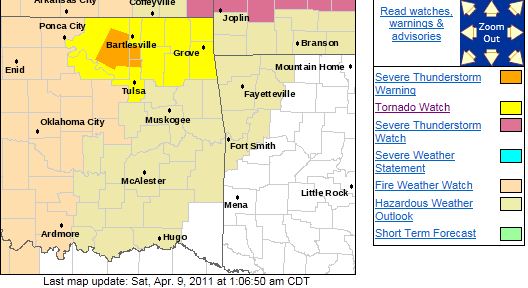 * AT 104 AM CDT...A SEVERE THUNDERSTORM WAS LOCATED 3 MILES SOUTH OF BARNSDALL...MOVING EAST AT 35
MPH. STORM HAZARDS INCLUDE... DAMAGING GOLF BALL SIZE HAIL... WIND GUSTS TO 60 MPH... * SOME LOCATIONS IN OR NEAR THE PATH OF THIS STORM INCLUDE...AVANT... SKIATOOK...OCHELATA...RAMONA...VERA
AND COLLINSVILLE. PRECAUTIONARY/PREPAREDNESS ACTIONS... PEOPLE OUTSIDE SHOULD MOVE TO A SAFE SHELTER...PREFERABLY
INSIDE A STRONG BUILDING. STAY AWAY FROM WINDOWS UNTIL THE STORM HAS PASSED.
Tornado Watch Issued THE NATIONAL WEATHER SERVICE HAS EXTENDED TORNADO WATCH 108 TO INCLUDE THE FOLLOWING AREAS UNTIL 3 AM CDT EARLY THIS
MORNING IN OKLAHOMA THIS WATCH INCLUDES 5 COUNTIES IN NORTHEAST OKLAHOMA DELAWARE
MAYES OTTAWA ROGERS
TULSA THIS INCLUDES THE CITIES OF...CLAREMORE...JAY...MIAMI... PRYOR AND TULSA. Large Hail, Damaging
Winds, and Tornado's are possible in the watch area. Please stay tuned to local media for possible warnings. 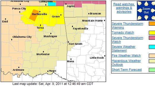
Friday, April 8, 2011
There is a Slight Risk Of Severe Weather for Areas North of I-44While the chance is slight, there is a possibility of a few severe storms this evening with higher chances in southern Kansas.
Large hail, damaging winds, and isolated tornado are possible. Here is the SPC graphic of the risk area. 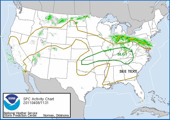
Wednesday, April 6, 2011
RED FLAG WARNING; WIND ADVISORY; BURN BAN - All in Effect URGENT - FIRE WEATHER MESSAGE
NATIONAL WEATHER SERVICE TULSA OK
904 AM CDT WED APR 6 2011
...DANGEROUS FIRE WEATHER CONDITIONS AGAIN TODAY... .STRONG AND
GUSTY SOUTH WINDS WILL CONTINUE TODAY ACROSS MOST OF
EASTERN OKLAHOMA AND NORTHWEST ARKANSAS WITH A DRY AIRMASS
REMAINING
OVER THE AREA. THE COMBINATION OF STRONG WINDS AND VERY
LOW HUMIDITY WILL ONCE AGAIN LEAD TO DANGEROUS FIRE WEATHER
CONDITIONS FROM LATE MORNING THROUGH MUCH OF THE AFTERNOON.
...RED FLAG WARNING IN EFFECT UNTIL 7 PM CDT THIS
EVENING...
THE NATIONAL WEATHER SERVICE IN TULSA HAS ISSUED A RED FLAG
WARNING...WHICH IS IN EFFECT UNTIL 7 PM
CDT THIS EVENING. FOR THE
FOLLOWING COUNTIES... IN OKLAHOMA...
OSAGE...WASHINGTON...NOWATA...CRAIG...OTTAWA...PAWNEE...TULSA...
ROGERS...MAYES...DELAWARE...CREEK...OKFUSKEE...OKMULGEE AND
WAGONER.

RELATIVE HUMIDITY LEVELS WILL FALL BELOW 25 PERCENT BY MID
MORNING. IN ADDITION...SOUTH WINDS OF 15 TO 25
MPH AND GUSTS NEAR
40 MPH WILL BE COMMON THROUGH AT LEAST MID AFTERNOON. THESE
WEATHER CONDITIONS WILL CAUSE ANY
FIRES TO SPREAD RAPIDLY AND BE
DIFFICULT TO CONTROL.
HUMIDITY LEVELS SHOULD RISE SIGNIFICANTLY THIS
EVENING...AND
COMBINED WITH A DECREASE IN WIND SPEED...WILL HELP REDUCE THE
FIRE THREAT.
PRECAUTIONARY/PREPAREDNESS
ACTIONS... A RED FLAG WARNING MEANS THAT A DANGEROUS COMBINATION OF WEATHER
CONDITIONS AND DRY VEGETATION IS EXPECTED
WITHIN 24 HOURS...
FAVORING RAPID GROWTH AND SPREAD OF ANY WILDFIRES. THE PRIMARY
WEATHER FACTORS INCLUDE STRONGER
WINDS...LOWER HUMIDITIES...AND
WARMER TEMPERATURES.
ADDITIONAL FIRE INFORMATION...INCLUDING CURRENT
COUNTY BURN
BANS...CAN BE ACCESSED FROM THE OKLAHOMA DEPARTMENT OF
AGRICULTURE AT: WWW.OK.GOV/~OKAG/ AND FROM THE ARKANSAS FORESTRY
COMMISSION AT: WWW.FORESTRY.STATE.AR.US. URGENT - WEATHER MESSAGE
NATIONAL WEATHER SERVICE TULSA OK
906 AM CDT WED APR 6 2011
...WIND ADVISORY IN EFFECT UNTIL 7 PM CDT THIS EVENING...
THE NATIONAL
WEATHER SERVICE IN TULSA HAS ISSUED A WIND ADVISORY...
WHICH IS IN EFFECT UNTIL 7 PM CDT THIS EVENING... FOR THE
FOLLOWING COUNTIES... * IN OKLAHOMA...CHEROKEE...ADAIR...CREEK...OKFUSKEE...OKMULGEE...
WAGONER...TULSA...ROGERS...MAYES...DELAWARE...PAWNEE...OTTAWA...
WASHINGTON...OSAGE...CRAIG...NOWATA...PITTSBURG...SEQUOYAH...
MCINTOSH...MUSKOGEE...LE FLORE...LATIMER
AND HASKELL. IN ARKANSAS...WASHINGTON...MADISON...CRAWFORD...BENTON...
SEBASTIAN...CARROLL
AND FRANKLIN.

HAZARDOUS WEATHER...
* STRONG AND GUSTY SOUTHERLY WINDS WILL CONTINUE ACROSS MUCH OF
EASTERN OKLAHOMA AND NORTHWEST ARKANSAS THIS MORNING AND INTO
THE AFTERNOON. WIND SPEEDS WILL DECREASE LATE
THIS AFTERNOON
AND EVENING FROM NORTH TO SOUTH AS A COLD FRONT SAGS INTO
NORTHEAST OKLAHOMA. IMPACTS...
* WIND GUST VALUES NEAR 40 MPH CAN BE EXPECTED FOR THE REST OF
THE MORNING AND MUCH OF THE AFTERNOON. *
WINDS THIS STRONG CAN MAKE DRIVING DIFFICULT...ESPECIALLY FOR
HIGH PROFILE VEHICLES. DEFINITION...
* A WIND ADVISORY MEANS THAT WIND GUSTS OF 40 MPH ARE EXPECTED. PRECAUTIONARY/PREPAREDNESS ACTIONS...
*
MOTORISTS SHOULD EXERCISE CAUTION WHILE DRIVING. BE ALERT TO
SUDDEN GUSTS OF WIND WHICH MAY CAUSE YOU TO
LOSE CONTROL OF YOUR
VEHICLE. EXTRA ATTENTION SHOULD BE GIVEN TO CROSS WINDS AND ON
BRIDGES AND OVERPASSES. * STAY TUNED TO NOAA WEATHER RADIO...COMMERCIAL RADIO OR TELEVISION
FOR THE LATEST INFORMATION CONCERNING THIS WEATHER EVENT.
ADDITIONAL WEATHER INFORMATION CAN ALSO BE FOUND
AT:
WEATHER.GOV/TULSA.
Very High Fire Danger Today - Burn Ban in EffectFIRE DANGER STATEMENT NATIONAL WEATHER SERVICE TULSA OK WED APR 6 2011 ...VERY HIGH FIRE DANGER
THROUGH THIS AFTERNOON... THE NATIONAL WEATHER SERVICE IN TULSA HAS ISSUED A FIRE WEATHER ALERT WHICH IS IN
EFFECT UNTIL 900 PM CDT FOR THE FOLLOWING COUNTIES... IN OKLAHOMA... OSAGE...WASHINGTON...NOWATA...CRAIG...OTTAWA...PAWNEE...TULSA... ROGERS...MAYES...DELAWARE...CREEK...OKFUSKEE...OKMULGEE AND WAGONER. 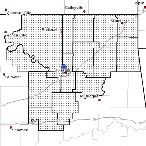 RELATIVE HUMIDITY LEVELS RECOVERED ONLY INTO THE 25 TO 35 PERCENT RANGE OVER MUCH OF NORTHEAST OKLAHOMA OVERNIGHT...AND
WILL FALL TO AROUND 20 PERCENT THIS AFTERNOON. SOUTH WINDS OF 15 TO 25 MPH WILL CONTINUE THROUGH THE MORNING...BUT
SPEEDS WILL DIMINISH BY THIS AFTERNOON AS A FRONTAL BOUNDARY APPROACHES FROM THE NORTH. BECAUSE OF THE DECREASE
IN WINDS...RED FLAG CONDITIONS ARE NOT EXPECTED TO BE MET OVER NORTHEAST OKLAHOMA. HOWEVER THE FIRE DANGER WILL REMAIN
VERY HIGH THROUGH THE EVENING...UNTIL HUMIDITY LEVELS RECOVER MORE SUBSTANTIALLY TONIGHT. BURN BANS ARE IN
EFFECT FOR PAWNEE...CREEK...TULSA AND OKFUSKEE COUNTIES IN EASTERN OKLAHOMA. A FIRE WEATHER ALERT IS ISSUED
WHEN DANGEROUS FIRE WEATHER CONDITIONS ARE EXPECTED BUT ARE BELOW RED FLAG CRITERIA. A FIRE WEATHER ALERT MAY ALSO BE ISSUED TO RELAY STATE OR COUNTY FIRE INFORMATION...SUCH AS BURNING BANS.
Tuesday, April 5, 2011
Red Flag Fire Warning and Burn Ban in Effect...RED FLAG WARNING IN EFFECT FROM NOON TODAY TO 9 PM CDT THIS EVENING... THE NATIONAL WEATHER SERVICE IN
TULSA HAS ISSUED A RED FLAG WARNING...WHICH IS IN EFFECT FROM NOON TODAY TO 9 PM CDT THIS EVENING. THE FIRE WEATHER
WATCH IS NO LONGER IN EFFECT. FOR THE FOLLOWING COUNTIES... IN OKLAHOMA... OSAGE...WASHINGTON...NOWATA...PAWNEE...TULSA...ROGERS...CREEK... OKFUSKEE...OKMULGEE...WAGONER...MUSKOGEE...MCINTOSH AND PITTSBURG. 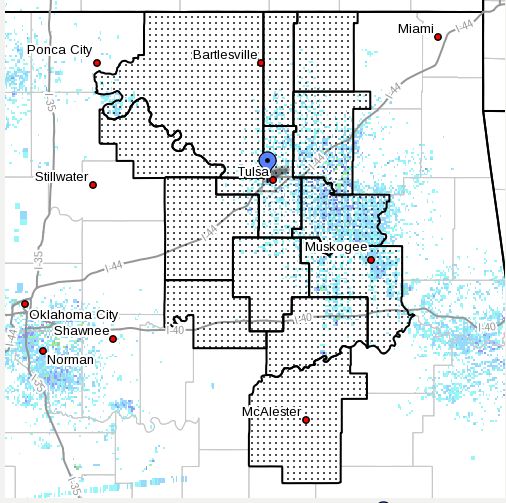 SOUTH WINDS FROM 15 TO 25 MPH WITH HIGHER GUSTS ARE EXPECTED THIS AFTERNOON OVER EASTERN OKLAHOMA. IN ADDITION...MINIMUM RELATIVE HUMIDITIES ARE FORECAST TO DROP TO LESS THAN 20 PERCENT. THIS WILL LEAD TO CRITICAL FIRE WEATHER CONDITIONS
WHICH FAVOR RAPID FIRE GROWTH. WIND SPEEDS WILL REMAIN IN THE 10 TO 20 MPH RANGE OVERNIGHT WITH HUMIDITY LEVELS
SLOW TO RECOVER. PRECAUTIONARY/PREPAREDNESS ACTIONS... A RED FLAG WARNING MEANS THAT A DANGEROUS COMBINATION
OF WEATHER CONDITIONS AND DRY VEGETATION IS EXPECTED WITHIN 24 HOURS...FAVORING RAPID GROWTH AND SPREAD OF ANY WILDFIRES.
THE PRIMARY WEATHER FACTORS INCLUDE STRONGER WINDS...LOWER HUMIDITIES...AND WARMER TEMPERATURES. DISPOSE
OF CIGARETTES PROPERLY AND AVOID ACTIVITIES THAT COULD START FIRES.
Monday, April 4, 2011
Freeze Warning Issued for Northern OklahomaURGENT - WEATHER MESSAGE
NATIONAL WEATHER SERVICE TULSA OK
359 PM CDT MON APR 4 2011
ARZ001-002-010-011-OKZ054>058-061>063-069-051000-
/O.EXP.KTSA.WI.Y.0002.000000T0000Z-110404T2100Z/
/O.NEW.KTSA.FZ.W.0003.110405T0600Z-110405T1400Z/
BENTON-CARROLL-WASHINGTON
AR-MADISON-OSAGE-WASHINGTON OK-NOWATA-
CRAIG-OTTAWA-ROGERS-MAYES-DELAWARE-ADAIR-
359 PM CDT MON APR 4 2011
...FREEZE WARNING IN EFFECT FROM 1 AM TO 9 AM CDT TUESDAY...
...WIND ADVISORY WILL EXPIRE AT 4 PM CDT THIS AFTERNOON...
THE NATIONAL WEATHER SERVICE IN TULSA HAS ISSUED A FREEZE
WARNING...WHICH IS IN EFFECT FROM 1 AM TO 9 AM CDT
TUESDAY...
FOR THE FOLLOWING COUNTIES...
* IN OKLAHOMA...ADAIR...ROGERS...MAYES...DELAWARE...OTTAWA...
WASHINGTON...OSAGE...CRAIG AND NOWATA.
IN ARKANSAS...WASHINGTON...MADISON...BENTON
AND CARROLL.
HAZARDOUS WEATHER...
* SURFACE HIGH PRESSURE WILL BUILD INTO THE REGION TONIGHT...WITH
CLEAR SKIES AND LIGHT WINDS. A DRIER AIR MASS WILL ALSO BE IN
PLACE...AND THIS SHOULD ALLOW TEMPERATURES
TO FALL BELOW
FREEZING BY TUESDAY MORNING.
IMPACTS...
* THESE CONDITIONS WILL KILL OR DAMAGE
PLANTS AND OTHER TENDER
VEGETATION THAT ARE LEFT OUTDOORS OR UNPROTECTED.
DEFINITION...
*
A FREEZE WARNING MEANS FREEZING TEMPERATURES WILL OCCUR.
PRECAUTIONARY/PREPAREDNESS ACTIONS...
* PRECAUTIONS
SHOULD BE TAKEN TO PROTECT SMALL PLANTS AND TENDER
VEGETATION.
* ADDITIONAL WEATHER INFORMATION
CAN ALSO BE FOUND AT:
WEATHER.GOV/TULSA.
Mon, April 4, 2011 | link
Wind Advisory Remains in Effect Until 4:00PMURGENT - WEATHER MESSAGE
NATIONAL WEATHER SERVICE TULSA OK
357 AM CDT MON APR 4 2011
...WIND ADVISORY
REMAINS IN EFFECT UNTIL 4 PM CDT THIS AFTERNOON...
A WIND ADVISORY IS IN EFFECT...
FOR THE FOLLOWING
COUNTIES...
* IN OKLAHOMA...CHEROKEE...ADAIR...CREEK...OKFUSKEE...OKMULGEE...
WAGONER...TULSA...ROGERS...MAYES...DELAWARE...PAWNEE...OTTAWA...
PUSHMATAHA...CHOCTAW...WASHINGTON...OSAGE...CRAIG...NOWATA...
PITTSBURG...SEQUOYAH...MCINTOSH...MUSKOGEE...LE
FLORE...LATIMER
AND HASKELL.
IN ARKANSAS...WASHINGTON...MADISON...CRAWFORD...BENTON...
SEBASTIAN...CARROLL AND FRANKLIN.
HAZARDOUS WEATHER...
* A STRONG COLD FRONT WILL PUSH SOUTHEAST
OF THE AREA BY
SUNRISE. BEHIND THE FRONT GUSTY NORTH WINDS WILL CONTINUE.
IMPACTS...
* WIND GUSTS TO 40 MPH WILL BE POSSIBLE THIS MORNING INTO THE
AFTERNOON HOURS.
* WINDS THIS
STRONG CAN MAKE DRIVING DIFFICULT...ESPECIALLY FOR
HIGH PROFILE VEHICLES.
PRECAUTIONARY/PREPAREDNESS
ACTIONS...
* MOTORISTS SHOULD EXERCISE CAUTION WHILE DRIVING. BE ALERT TO
SUDDEN GUSTS OF WIND WHICH
MAY CAUSE YOU TO LOSE CONTROL OF YOUR
VEHICLE. EXTRA ATTENTION SHOULD BE GIVEN TO CROSS WINDS AND ON
BRIDGES AND OVERPASSES.
* STAY TUNED TO NOAA WEATHER RADIO...COMMERCIAL RADIO OR TELEVISION
FOR THE LATEST INFORMATION CONCERNING THIS WEATHER EVENT.
ADDITIONAL WEATHER INFORMATION
CAN ALSO BE FOUND AT:
WEATHER.GOV/TULSA.
Mon, April 4, 2011 | link
Sunday, April 3, 2011
Severe Thunderstorm Watch PossibleThe storms are developing a little further
west than expected and the SPC appears to be preparing to issue a Severe Thunderstorm Watch for eastern Oklahoma. Here is the SPC discussion graphic of where the watch will be issued.
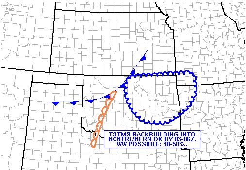
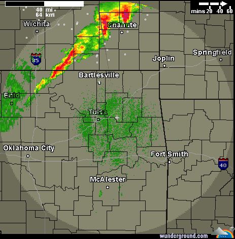
Here is the latest radar image:
Severe Threat has Lessened, Record High Tied at 88.It appears the more significant severe
weather threat will remain well north and east of the Tulsa area. Thunderstorms are still expected last this evening but most are expected to remain below severe
limits.
RECORD EVENT REPORT
NATIONAL WEATHER SERVICE TULSA OK
0445 PM CDT SUN APR 03 2011
...RECORD HIGH TEMPERATURE SET AT TULSA OKLAHOMA...
A RECORD HIGH TEMPERATURE OF 88 DEGREES WAS SET AT TULSA
OKLAHOMA
TODAY. THIS TIES THE PREVIOUS RECORD OF 88 SET IN 1965.
Slight Risk of Severe Weather TonightThere is a slight risk of severe weather tonight for most of eastern Oklahoma east of I-35. High winds, damaging hail, and
possibly a tornado could occur in the risk area. Should severe weather occur, it will likely be late this evening
into the overnight hours. Here is the SPC graphic of the risk area: 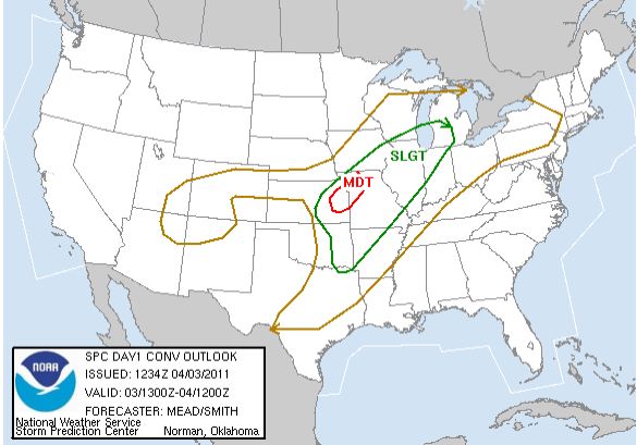 There is also a High Fire Danger for the area today as winds gust to 45MPH will allow any fire to quickly
get out of control.
Saturday, April 2, 2011
WIND ADVISORY IN EFFECT FROM 9 AM TO 7 PM CDT SUNDAY402 PM CDT SAT APR 2 2011
...WIND ADVISORY IN EFFECT FROM 9 AM TO 7 PM CDT SUNDAY...
THE NATIONAL WEATHER
SERVICE IN TULSA HAS ISSUED A WIND ADVISORY...
WHICH IS IN EFFECT FROM 9 AM TO 7 PM CDT SUNDAY...
FOR THE
FOLLOWING COUNTIES...
* IN OKLAHOMA...WASHINGTON...OSAGE...CRAIG...NOWATA...PAWNEE...
OTTAWA...TULSA...ROGERS...MAYES
AND DELAWARE.
HAZARDOUS WEATHER...
* LOW PRESSURE WILL STRENGTHEN TO THE NORTH AND NORTHWEST...AND
THIS WILL BRING VERY STRONG SOUTH WINDS TO NORTHEAST OKLAHOMA
ON SUNDAY. SUSTAINED WINDS FROM 25 TO 30 MPH
CAN BE EXPECTED
WITH HIGHER GUSTS.
IMPACTS...
* WIND GUSTS OF AROUND 40 MPH ARE POSSIBLE.
* WINDS THIS STRONG CAN MAKE DRIVING DIFFICULT...ESPECIALLY FOR
HIGH PROFILE VEHICLES.
DEFINITION...
* A WIND ADVISORY MEANS THAT WIND GUSTS OF 40 MPH ARE EXPECTED.
PRECAUTIONARY/PREPAREDNESS
ACTIONS...
* MOTORISTS SHOULD EXERCISE CAUTION WHILE DRIVING. BE ALERT TO
SUDDEN GUSTS OF WIND WHICH
MAY CAUSE YOU TO LOSE CONTROL OF YOUR
VEHICLE. EXTRA ATTENTION SHOULD BE GIVEN TO CROSS WINDS AND ON
BRIDGES AND OVERPASSES.
* STAY TUNED TO NOAA WEATHER RADIO...COMMERCIAL RADIO OR TELEVISION
FOR THE LATEST INFORMATION CONCERNING THIS WEATHER EVENT.
ADDITIONAL WEATHER INFORMATION CAN ALSO BE FOUND
AT:
WEATHER.GOV/TULSA.
Sat, April 2, 2011 | link
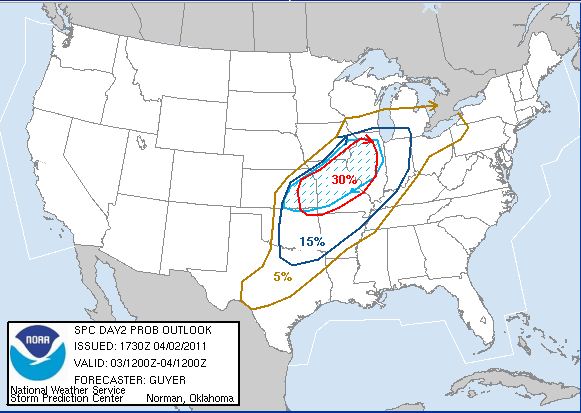
There is a Slight Risk of Severe Weather Sunday Afternoon and EveningStrong winds and large hail are the primary threats primarily north and northwest of Tulsa.
Here is an SPC graphic
depicting the risk area:
|